
Despite ample evidence that streetcar tracks injure and maybe even kill people biking, plans for a downtown streetcar line on 1st Ave and Stewart Street do not include any adjacent bike lanes or any other measure to make the tracks safer.
To put it bluntly, the $135 million Center City Connector Streetcar as currently planned would make downtown more dangerous for people on bikes than it is today. If constructed, people will be seriously injured or killed.
By providing no mitigation for the new biking dangers along its entire route, the plans also seem to disregard Seattle’s complete streets ordinance requiring major projects to consider the needs of all road users. In fact, the project would even remove an existing (if substandard) bike route on Stewart.
To make matters worse, no mitigation for bike dangers was even studied in the otherwise exhaustive draft environmental assessment released recently. It’s not as though bike lanes were studied and deemed impossible for this alignment. They weren’t even studied. An investigation into options for making tracks safer for bike tires — including skinnier flange gaps and options for filling gaps — would also be good to add to the study (UPDATE: This brand new study (PDF) out of the UK is a treasure trove on the topic).
Instead, planners determined that the streetcar “would not affect bicycle access along First Avenue” because there are bike lanes on 2nd. This is maddening logic, especially for a street with as many businesses and destinations as 1st Ave. You have to bike on 1st to get to destinations on 1st. That should be obvious. So saying this streetcar would not affect bicycle access along 1st Ave is simply not true. It doesn’t matter if 98 percent of a trip does not injure someone. It needs to be 100 percent.
SDOT consistently says that safety is the agency’s top priority, and the city’s Vision Zero policy calls for zero traffic deaths and serious injuries by 2030. Building a streetcar line that we know will cause injuries or death is in direct conflict with these policies.
Why build this streetcar?

Before diving into the weeds on this project, I should note that I really want to like this streetcar. Its ridership numbers are much stronger than the existing streetcar lines, and it makes sense to actually connect those fledgling lines to make them more useful. Streetcars are also kinda cool, and I’m generally in favor of reallocating space on downtown streets to improve transit capacity and times.
And there are a lot of smart people working on this project. They understand that it not only needs to be efficient, but it also needs to provide a retail-level transit service to get people around downtown’s neighborhoods as more homes and jobs are added.
I agree that the general 1st Ave/Stewart alignment was the best of the options studied initially. But only if it is safe.
And that’s the problem. None of these benefits are worth harming people’s lives.
1st Ave
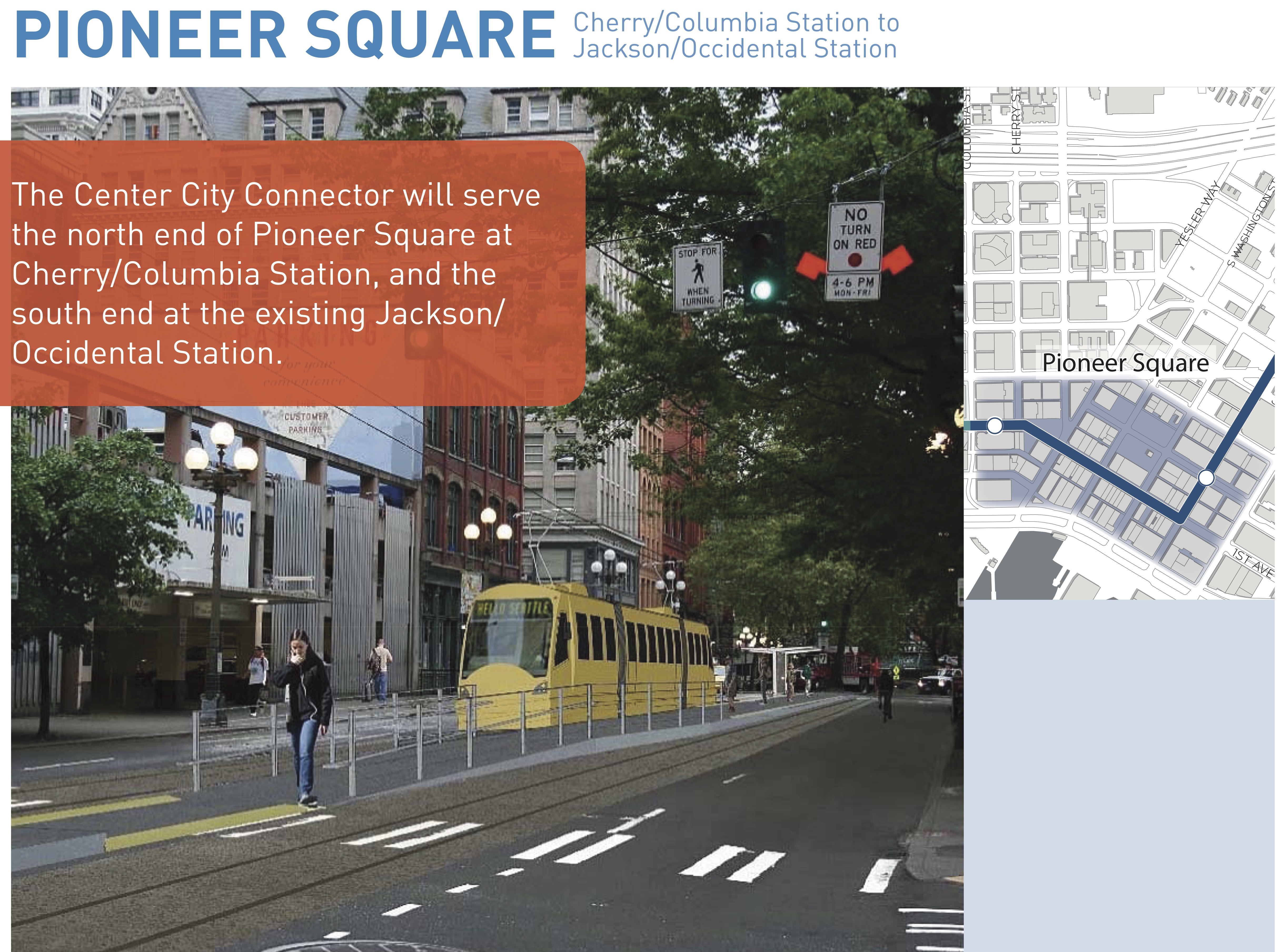
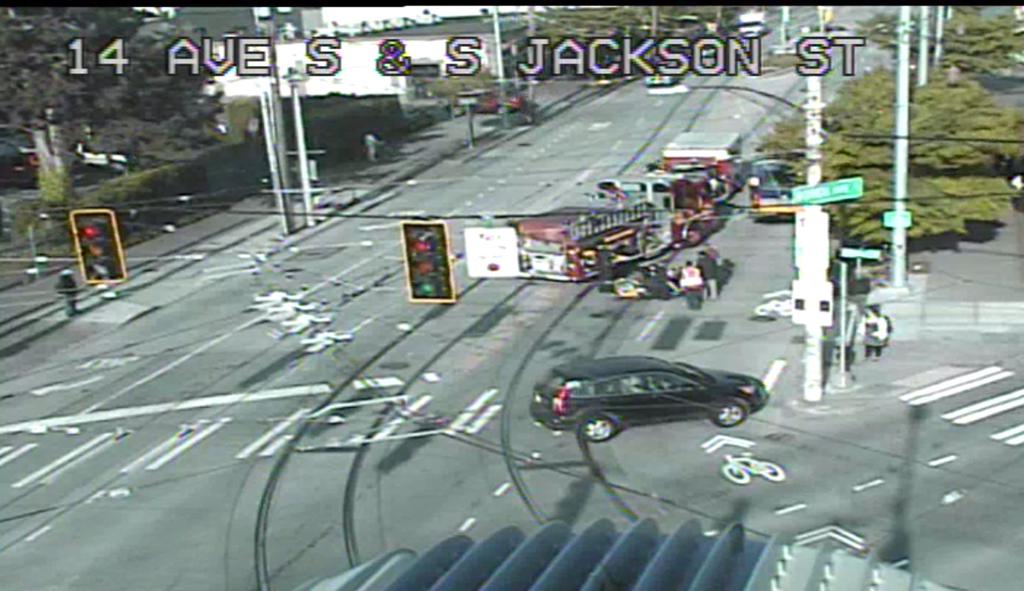
 To get a sneak peek at the future of 1st Ave, just go down to Jackson Street in Pioneer Square during rush hour. This is essentially the exact same design as is planned for 1st Ave, except that the center streetcar lanes will be transit-only.
You will see lots of people biking precariously over the tracks. Only luck (and sometimes skill) keeps their tires from getting caught in or slipping on the metal rails. But sometimes, people aren’t so lucky:
This crash resulted in a badly broken collar bone. It could have been far worse. The person biking, Seattle Neighborhood Greenways’ Bob Edmiston, is experienced and knew to cross the tracks at close to a 90 degree angle. He just made a slight mistake and straightened out too soon, catching his rear wheel in the track. That’s all it takes, especially when the tracks are wet (which is common in Seattle).
So one danger the tracks pose is for people turning on and off of the street like Bob was. Another common danger is caused when a vehicle or line of traffic is stopped or moving slowly in the right lane. People biking who attempt to pass are in danger of hitting the tracks.
One year ago, Daniel Ahrendt was passing a bus on Jackson Street near Rainier Ave when his tire got caught in tracks, sending him crashing under the wheels of that bus. In May, Desiree McCloud was passing a friend on Yesler when the tracks may have caused her to crash. She passed away from her injuries a week and a half later.
The plans for 1st Ave do not mitigate these known dangers. The city can’t repeat a dangerous design and expect different results.
Seattle Neighborhood Greenways is currently gathering signatures on a petition calling on the city to take swift action to fix dangers on Yesler Way and to create a policy for including protected bike lanes adjacent to all streetcar lines citywide. That certainly includes the Center City Connector.
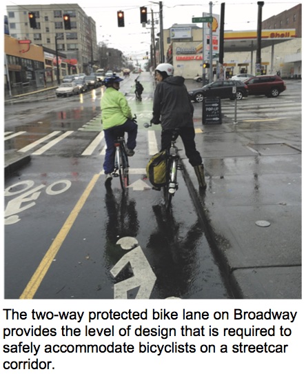
As we wrote during early planning for this project in 2013 (comments that were apparently missed or ignored), the only solution is to build protected bike lanes adjacent to the tracks like on Broadway. In fact, project planners acknowledge as much in an appendix (caption theirs):
 They are right.
Of course, this isn’t easy. One option would be to sacrifice the exclusive transit lanes and run the streetcars in mixed traffic instead. This is not good for transit times, and would likely reduce ridership. But it would preserve two-way traffic flow. Here’s what that could look like, as Seattle Bike Blog mocked-up using Streetmix:
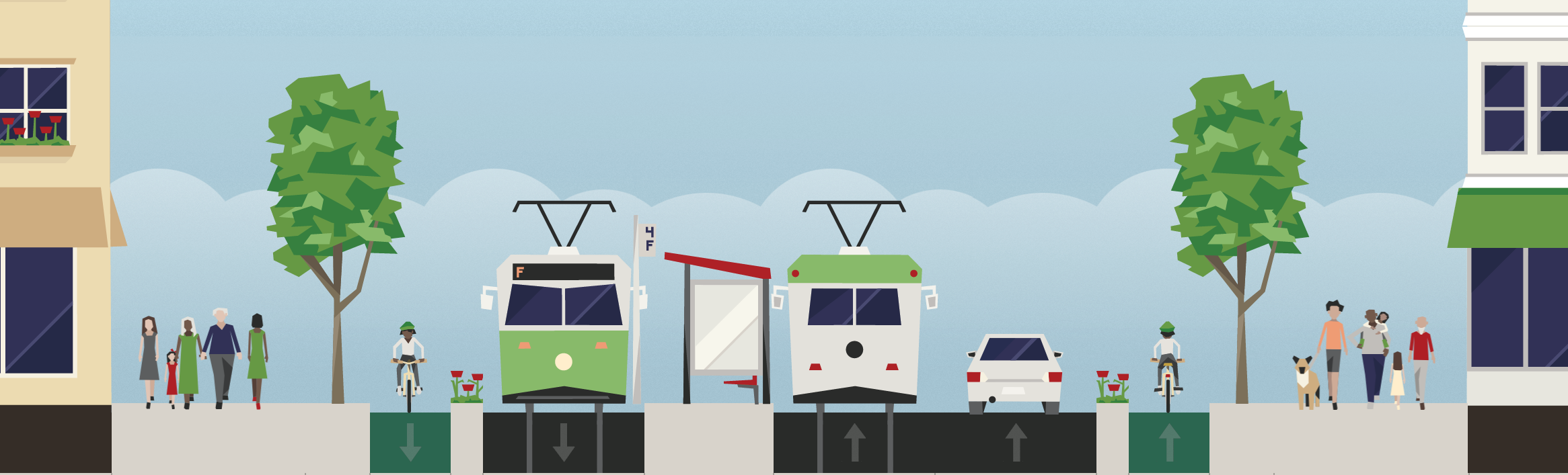
Our reasoning is that since 2nd Ave is southbound-only, 1st Ave is more important as a northbound corridor. And remember that the state is building a huge surface highway nearby on the waterfront, opening more options for people driving while degrading transit and walking.
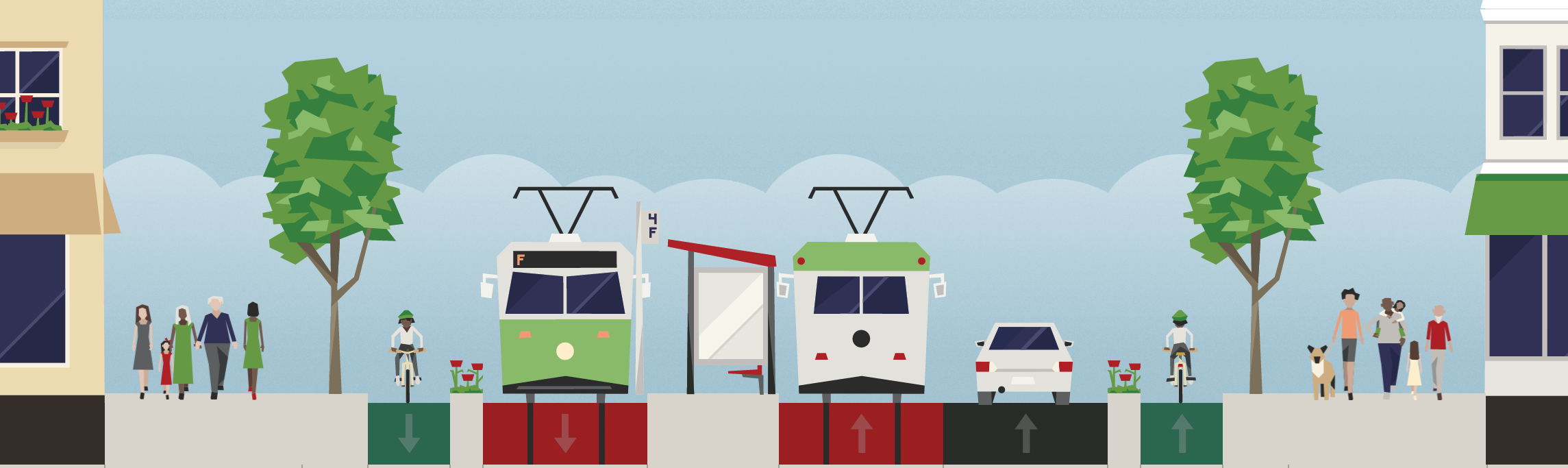
Another option is to go all out and keep the exclusive lanes and the bikeway. Route southbound general traffic over to 2nd Ave or the new waterfront highway. The city could then make 1st Ave northbound-only:
 Or if business access is prioritized, restrict through-traffic like on 3rd Ave so people can only drive one block at a time. That way people can drive to access loading zones or parking garages, but shouldn’t clog the streetcar lanes with traffic:
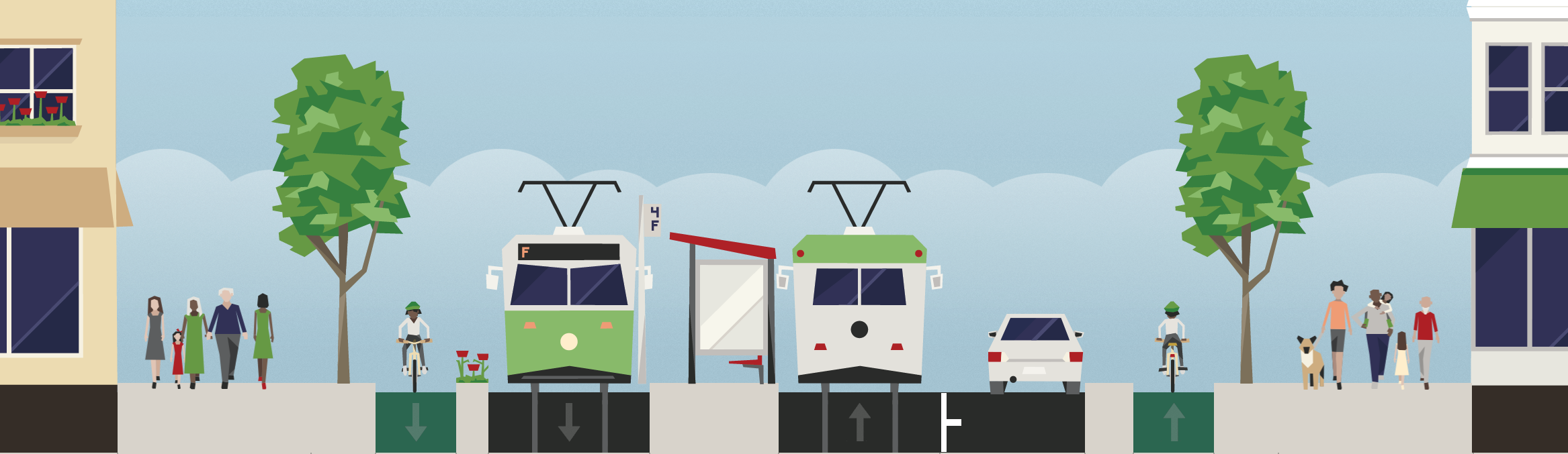
All these options would also dramatically improve the walking experience on 1st Ave since crossing distances would be much shorter and traffic levels much lower.
Stewart Street
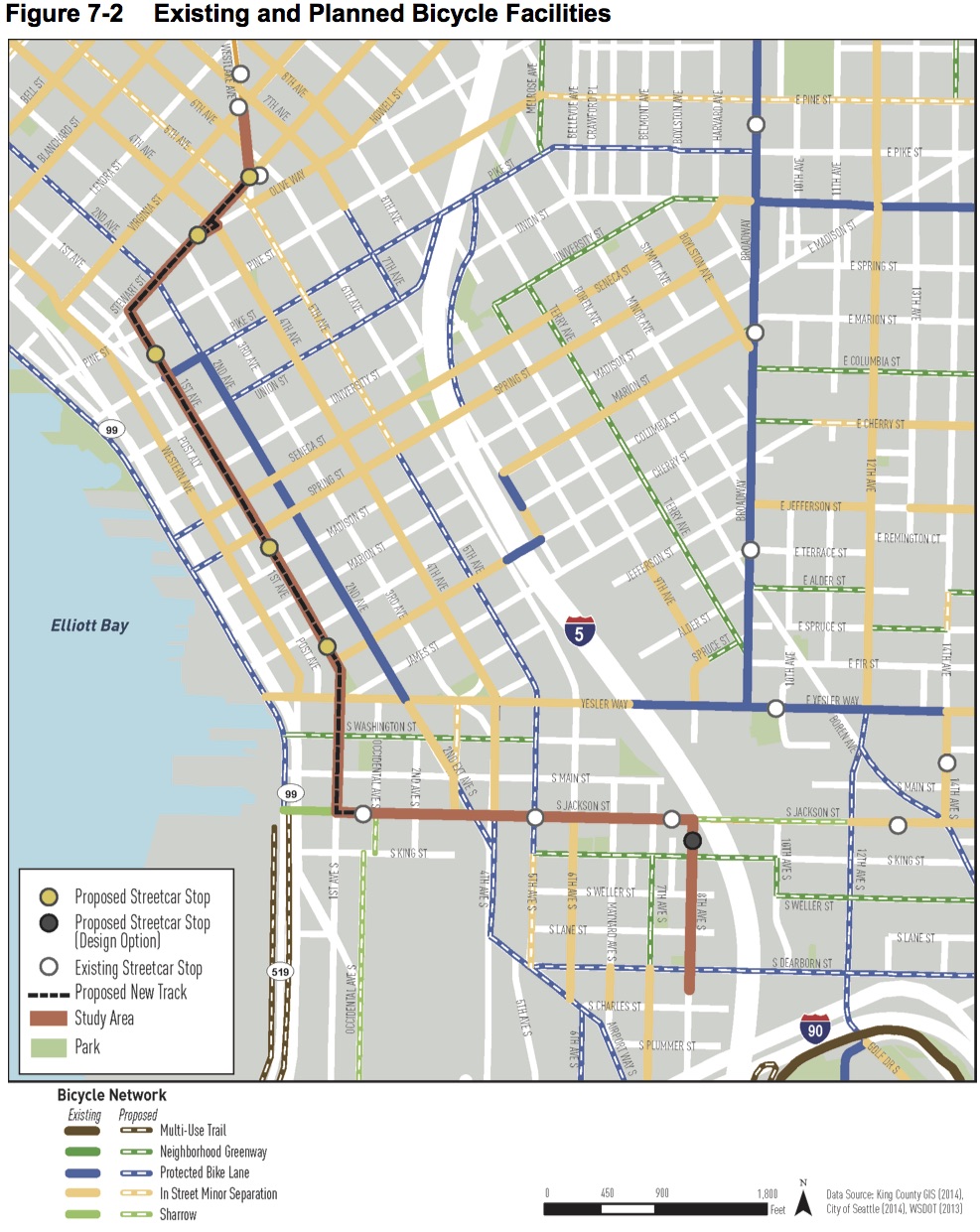
Stewart is even worse than 1st Ave because Stewart is a vital bike corridor. It’s a rare street diagonal to the grid that connects various bike routes into (and, with a two-way bikeway, out of) downtown.
Stewart is marked with sharrows today, but the Roosevelt-to-Downtown High Capacity Transit project recently showed plans to add two-way protected bike lanes on Stewart.
Planning teams have apparently not been coordinating because the streetcar plans actually remove the bike route on Stewart and replace it with … nothing!
“Shared lane markings would be removed on Stewart Street between Sixth and First Avenue,” the environmental study notes. “The elimination of these routes as designated bikeways would not have a major impact on bicyclist access because there is a comparable parallel route one block north of Stewart Street, on Virginia Street.”
Not only does Virginia Street have no bike lanes (and this project is not proposing to add them), but it is also one-way in the opposite direction. And unlike Stewart, Virginia does not connect to Eastlake Ave E, a major bike route. And to make matters worse, Virginia has a very dangerous crossing of — you guessed it — the existing streetcar tracks on Westlake Ave.
This project must install protected bike lanes on Stewart. It’s the only option that is safe. And a different SDOT project is already planning one, so this isn’t just some bike blog saying this.
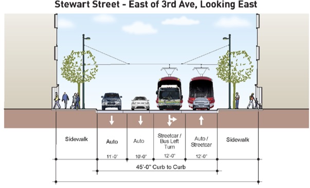
Here’s the Center City Streetcar design for Stewart:
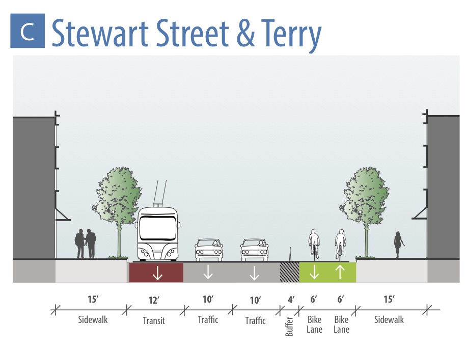
 And here’s the Roosevelt-to-Downtown project’s design for Stewart:
 There is plenty of space on Stewart for transit lanes and bike lanes. It just may require removing general purpose lanes or turn lanes. But removing the bike lanes is not an option because that is a recipe for serious injury or death.
Safety is the top priority. Period.
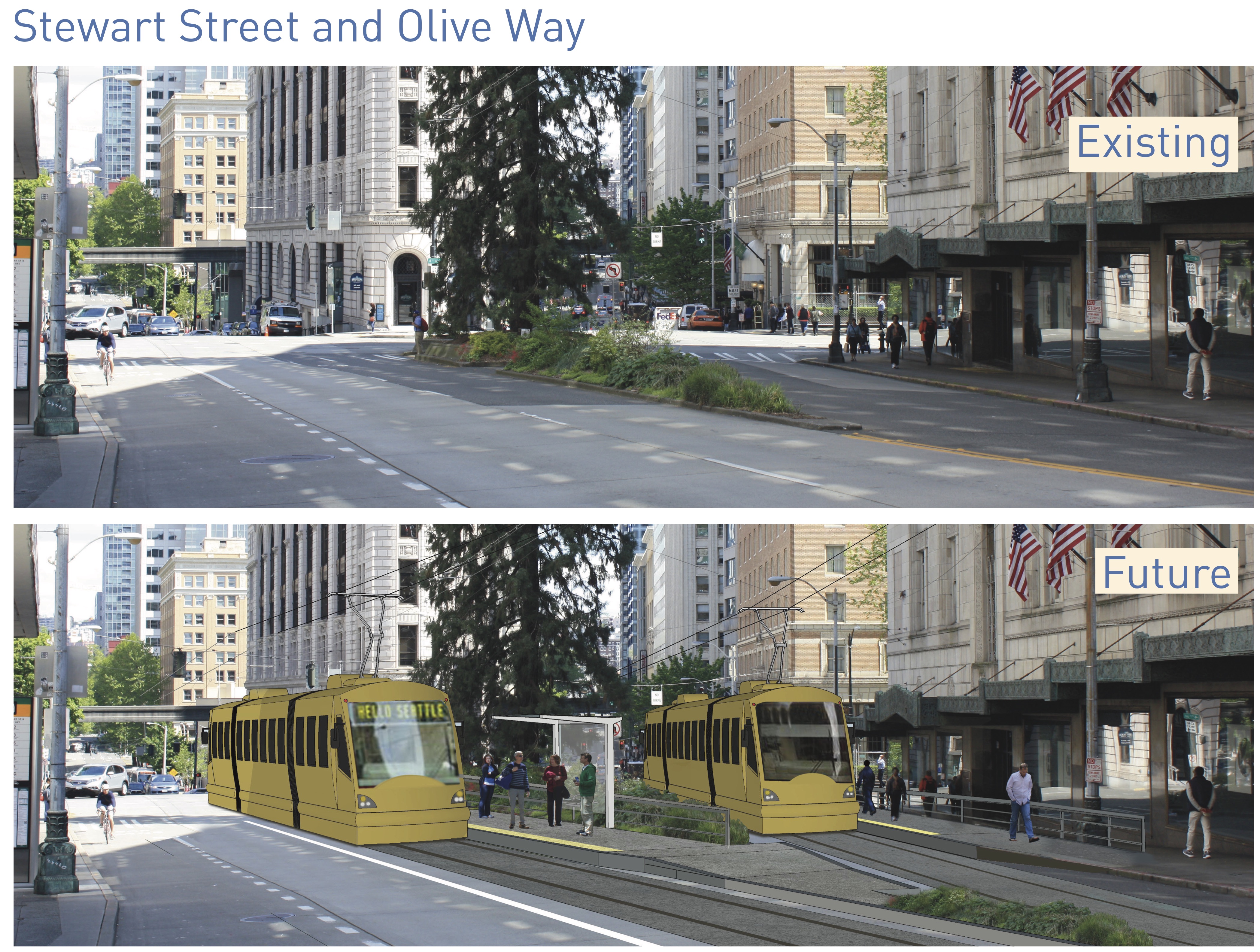
The streetcar team also needs to rethink the intersection with Olive (see photos at top) because their current design leaves no space for people who will inevitably bike that way.
Conclusion
It’s disappointing that bike safety was not included more significantly in this study and in the designs. These issues were raised early in the design process and were apparently disregarded. So now we’re in a place where big design changes are needed after all this environmental study has been completed.
Without a safe plan, this project is probably going to face direct and loud opposition from safe streets advocates. And with support for streetcars already fairly weak in this town, I don’t see how they can weather safe streets opposition as well. Who is left supporting it? The safe streets movement is organized and willing to show up and be loud if that’s what it takes.
On the flip side, if this project included big improvements to safety and walk/bike mobility, it could have the enthusiastic support of safe streets advocates instead. I would much rather support something representing a bold walk/bike/transit vision for downtown than oppose this streetcar.
This is just the draft environmental assessment. So the team has a lot of work ahead of them before releasing the final version.
Comments can be emailed to [email protected].


Comments
70 responses to “Downtown streetcar plans would make 1st Ave, Stewart more dangerous for biking”
Wasn’t the whole point of the Center City Connector to replace the waterfront streetcar? Aren’t there supposed to be transit-only lanes on the new Alaskan Way, where a streetcar could go, with a separate, protected cycletrack that would avoid this entire problem?
Nah, the CCC has never had much to do with the waterfront streetcar. There’s never been a plausible rail connection between Alaskan Way in the vicinity of Pike Place and the Westlake Center end of the SLU Streetcar (there’s hardly a plausible road connection — it would probably take a cable car to do it by rail). And the transit lanes planned for the waterfront are mostly designed to get buses from West Seattle into downtown, so they don’t extend very far north of the ferry terminal.
Here is my proposal for the Stewart area:
1. Make Pine two-way transit-only and route the streetcar from 1st to 5th there. This would also greatly improve transfers from buses to the tunnel as both eastbound bus stops and tunnel entrances will finally be on the same street.
2. Make Pike a regular two-way street and build a protected cycle track on it already!
3. Build a protected cycle track on Stewart connecting the Roosevelt project work with 1st.
With respect to Stewart, the existing SLU streetcar and the RapidRide C (and the #40 bus) already share a bus-only lane in one segment. Is that not possible with the new line?
It actually seems to work pretty well for the transit modes because the high frequency of the buses effectively “sweeps” the route of poorly parked cars and car drivers overhanging the lane, blocking the box and the like, which would otherwise block the streetcar.
No accommodation on the street?
No mitigation to create parallel facilities?
No thought given to how people who need to bike to destinations along the route will safely get there?
All work on planning the Center City Bike Network has been stopped?
It feels like SDOT is just admitting that safety isn’t a priority.
Now you guys are just losing your minds. One streetcar-load of commuters takes a dozen (or two) cars off the road. Keep lobbying for protected bike lanes—full bore (instead of tilting windmills) :/
Signed: Joan, a stalwart advocate of protected bike lanes—and huge fan of environmentally sustainable public transportation
Then join us in the call for the full-on walk/bike/transit vision for 1st Ave I suggested (or something similar).
Tom, we cannot afford to have another Broadway fiasco. I much rather bike to the new waterfront PBLs or the 2nd Ave PBLs in favor of maintaining exclusive streetcar ROW.
3 PBL in parallel would be nice, but not at the expense of transit ROW.
Joan, do you use Stewart/1st much at all via bicycle?
I sure do, those are my two main routes around the downtown core and to get to the waterfront (no, I will not use 2nd ave to this day – 1st is more direct with less cross traffic and well timed-lights and Stuart is really good right now).
But this eviscerates pretty much the remaining good bike routes into/out of/through the Seattle core for those on bicycles. I really think that SDOT doesn’t think about “safety” – they don’t think at ALL nor require any planners to require integration of cycling as a valid transit option.
Removing good routes for cyclists doesn’t automatically mean “poof” now we have good transit options. They should work together and SDOT is clearly not making sure it happens.
The probably more ideal connector is a couplet on 4th/5th Aves. It doesn’t make sense to have both curbside and median transit stops on 1st Ave. Trolleybuses on 1st Ave could run at more frequent intervals and ‘straight’ to Queen Anne instead of jogging over to 3rd Ave.
To improve the Lake Union Streetcar, from Westlake, a loop turning west on Lenora would turn south on 1st or 2nd Ave, then east on Pike, then north on 6th to Westlake.
The First Hill Streetcar line from Jackson could turn north on this ‘level’ stretch of 1st Ave, then west to Alaskan Way at Yesler according to the Sdot study. It’s possible to extend the Waterfront Streetcar route north on Elliott to 3rd Ave W, then some street north to Seattle Center terminus with possible extension further to Westlake.
This streetcar connector on 4th/5th Aves could be considered last on the wish list; after the Lenora/Pike Loop; after the Waterfront Streetcar line; after the trolleybus system on 1st is upgraded.
I tend to stay off of 1st Ave
Seattle being what it is, doesn’t mean the bicycle clique need have no regard for streetcar, transit, pedestrian and clean air advocates. I go to political rallys to propose what to do instead of what not to do. Above I’ve suggested alternative streetcar connector and expansion routes as alternatives. Protest streetcar on 1st Ave all you like; without an alternative, the powers-that-be don’t give a damn what bicyclers need to ride safely through town and neighborhood.
>> One streetcar-load of commuters takes a dozen (or two) cars off the road.
Right, except that such a thing never exists. Our streetcars are never full. Our buses, on the other hand, our routinely full.
Simply replace the streetcars with BRT buses (like they will be using on Madison). Problem solved. They have similar capacity, and the same off board payment and multi-door boarding as streetcars, without any of the disadvantages (they can go up hills and avoid obstacles).
Heh. Try our 1st Hill streetcar (if you want full). Or, try even the Amazonia streetcar during rush hour (if you want crammed)
I would prefer BRT or electric busses to streetcars too. I don’t understand the facination with streetcars especially those with shared ROW. Total waste of money.
SNG’s position about a citywide streetcar policy is a more nuanced and less absolute than the first draft of the petition. The main point of it, that you echo here, is that the city needs to be actively working on how to provide safe access and reduce conflicts. It’s concerning that it appears this has not happened with the center city connector.
If SDOT is going to pass off the 2nd Ave bike facility as an alternative to 1st Ave, it should commit to closing the adjacent traffic lane whenever the bike facility is closed. Of course, they should be doing that already, but here’s a yet another great reason for them to do that.
Maybe someone can help me… where is the Second Avenue entrance to the Pike Place Market? In all the years I’ve been going there, I’ve always used First Ave.
Pike Street
I must have missed the overpass, how does that bypass First Ave?
1st Ave goes 4-way stoplights for motor vehicles—allowing pedestrians and bicycles reign across the intersection
And how does a stop light levitate bicycles over streetcar tracks?
You’re just proving that the draft EIS is lying when it says rails on 1st Ave won’t affect bicycles.
How do bicycles get to the waterfront without crossing 1st Ave?
Um… the N-S tracks would be perpendicular to E-W egress? I grew up in rural Wisconsin and rural Michigan where train tracks abound. You learn tracks at an early age
We also learned potholes and ice
So, in other words, having tracks on First *would* affect bicycles.
I’m not saying it’s impossible to ride over tracks, I’m just saying the Draft EIS is patently false when it claims there are no bicycle impacts on First Avenue because First Avenue doesn’t support bicycles.
Even five minutes standing on a corner at rush hour will prove how false that claim is. First Avenue currently supports significant bicycle traffic, both along the avenue and across it. Tracks will affect both.
Even if the City decides to go ahead with the project as designed, it’s fundamentally dishonest to claim the bicycles simply aren’t there today.
The worst part is that Jackson and 1st, an intersection lots of people ride through because of the large number of destinations nearby and along most streets, will have streetcar tracks curving through it just like 14th/Jackson, making it pretty hard to ride through in most directions.
I dislike streetcars as much as the next person, but I’m going to play the European card on this one. At what point do we need to start expecting a little bit of responsibility on the cyclist’s part? In Europe, bikes and streetcars get along just fine. Most European cities have cyclists and streetcars mixing constantly, most of the time with little to no warning or signage. For an example, check out the Bremen city center:
https://www.google.com/maps/place/Bremen,+Germany/@53.0748945,8.8084429,116m/data=!3m1!1e3!4m5!3m4!1s0x47b128100ceee335:0xc2e8885cf937df51!8m2!3d53.0792962!4d8.8016937
That wye of streetcar tracks is actually wide open for pedestrians and cyclists, who mix interchangeably with active streetcars and on cobblestone to boot! Check out the 360 views around the area to see great examples. Here’s a good example:
https://www.google.com/maps/place/Bremen,+Germany/@53.0755355,8.8078584,3a,75y,158.93h,74.35t/data=!3m8!1e1!3m6!1s-dzYsfC56Nfg%2FVYKM0cQuJSI%2FAAAAAAAAA1Y%2FDitEJy3K9woRjeHnY5udgYpNiZmsnqrCgCLIB!2e4!3e11!6s%2F%2Flh4.googleusercontent.com%2F-dzYsfC56Nfg%2FVYKM0cQuJSI%2FAAAAAAAAA1Y%2FDitEJy3K9woRjeHnY5udgYpNiZmsnqrCgCLIB%2Fw318-h100-n-k-no%2F!7i12288!8i3864!4m5!3m4!1s0x47b128100ceee335:0xc2e8885cf937df51!8m2!3d53.0792962!4d8.8016937!6m1!1e1
Now back to Seattle. Why do our cyclists have so much trouble with (in my opinion) very well signed and striped streetcar track crossings?
Hear hear! I choose to cycle along these tracks on Westlake and understand that I need to be careful.
Are you sure your comparison works? In the first photo, it’s hard to tell how the street is used. However, it looks like there might be bikeways on the edges of the street area with right-angle crossings of the tracks at the intersections.
In the second photo, there’s so much open space and no traffic that it is a big stretch to compare to Jackson street.
In the Prague, the city is laced with streetcar tracks. They have a very low bicycle ridership. I don’t know how much that has to do with the hazards of riding and the hills (very hilly there) or the fact that they have excellent transit.
The street is pretty much a free for all. Here’s another photo of the area that shows the situation:
https://www.google.com/maps/place/Bremen,+Germany/@53.0755787,8.8081169,3a,60.8y,119.82h,92.69t/data=!3m8!1e1!3m6!1s-bC1IpI25624%2FV17jODtrSCI%2FAAAAAAAAAdM%2FPqqmaabki84gSpgxKp1AN-q7WEmOE2pAgCLIB!2e4!3e11!6s%2F%2Flh3.googleusercontent.com%2F-bC1IpI25624%2FV17jODtrSCI%2FAAAAAAAAAdM%2FPqqmaabki84gSpgxKp1AN-q7WEmOE2pAgCLIB%2Fw203-h101-n-k-no%2F!7i8704!8i4352!4m5!3m4!1s0x47b128100ceee335:0xc2e8885cf937df51!8m2!3d53.0792962!4d8.8016937!6m1!1e1
I’m not saying we need to revert to medieval era city centers, but it seems like the signs and road paint we currently spec in our City are enough. Sure there are a few accidents, but to eliminate those few accidents, we would very quickly reach an asymptote for spending vs. accident reduction. I would much rather spend that money on reducing accidents due to LACK of infrastructure.
I also cycled in Amsterdam and Melbourne ( which has the largest streetcar network), and did not see cyclist there all in a huff about streetcars.
It’s a myth that Europeans are more skilled or knowledgeable to mix with street cars. More protected bike lanes and slower speeds overall may help, but Tom posted a study yesterday on Twitter that had found widespread issues across the world: https://twitter.com/seabikeblog/status/746120192594317312
When it comes to urban bicycling, there are two differences between European cities and Seattle. Europeans ride upright where it’s easier to see what’s ahead, and they ride at slower speeds. They don’t even try to keep up with auto traffic.
Based on random crap I’ve read on the Internet, it sort of sounds like:
1. Euros crash on streetcar tracks, too — we might hear about it more if streetcars were novel there, or if we were regular readers of Europe Bike Blog
2. Euros don’t have to ride in arterial car traffic as much, which means there’s less stuff to pay attention to (the tracks are relatively more prominent) and crashes are less severe (I crashed on a rain gutter in Occidental Park once and was back up and riding in about 5 seconds, no report needed)
3. For a variety of reasons (including riding in arterial traffic less often) Euros probably ride slower on average than Seattle people, making crashes easier to avoid and less severe
4. Urban arterial streets in America have so many signs that drivers can’t really process the ones they’re not already expecting (I didn’t make that up, there are studies about it), so a novel sign indicating streetcar tracks may go completely unnoticed, especially by new cyclists
5. Maybe urban cyclists in Europe are more experienced on average, or have wider tires on average
I don’t think Europe is this magical place where cyclists just know what to do. If you grab a bunch of cyclists from all over the world and tell them to ride downtown Seattle from 16th/Jackson, or to ride to the International District from the 2nd Ave Extension, a lot of people will have a lot of problems.
Also, signs for cyclists are posted between 8-10ft off the ground, whereas a cyclist’s eye level is at 4-5ft. Here is a sign for the Westlake tracks that I completely missed because it was outside of my field of view (compare the guy walking next to it for height) and because it’s posted right at the intersection where I was trying to pay attention to cars to my left that might be turning across my path, not cranking my head back and to the right to read signs:
https://www.google.com/maps/@47.6175938,-122.3387524,3a,26.7y,69.6h,78.42t/data=!3m6!1e1!3m4!1s0fjPA7KXQJ5Vq6Vgyq1Zlw!2e0!7i13312!8i6656!6m1!1e1
This is a good point that we don’t talk about often enough. High signage is fine for drivers reclining in their bucket seats, but for cyclists bent over their handlebars, we’re much better off looking at waist-level signs or warnings painted on the street itself.
European city bikes also tend to have wider tires than American road bikes — with our lower density and longer distances, more American cyclists care more about weight and speed, even for urban riding.
When my commute began to include rail gaps, I switched to riding 1.5″ tires — not as light or quite as fast as my road bike, but a heck of a lot more stable when making diagonal rail crossings. They don’t drop into the flange gap of Seattle’s streetcar rail profile until they’re within less than 30 degrees of the rail direction. Still need to watch out for slipperiness and attempted crack-steering, but at least they don’t drop in and get stuck.
Sign height is full of compromises —
If a sign hangs over the roadway, it has to be high enough to allow tall vehicles to pass.
If it hangs over the sidewalk, it needs to be high enough that pedestrians don’t hit their heads.
Since Seattle doesn’t have much of a snow problem, pavement markings really would be a better warning system for rails.
Exactly. I’ve ridden through Bremen city centre. At first, it seemed terrifying, but I learned it
Maybe we should make Seattle’s bike lanes out of that spongy tarmac they use in kids’ play parks (in case we fall down)
You realize the Bremen city center is closed to automobiles (outside of construction access and deliveries), right?
Not having to worry about being pinched by cars in lanes when making turning movements around tracks makes it a much more comfortable experience, and really isn’t analogous to how bikes interact with streetcar tracks in Seattle.
I don’t understand streetcars. They’re much more expensive than buses. They get caught in the same traffic or worse since they get completely stuck by one double-parked car. And the tracks make the roads much more dangerous for cyclists. What am I missing?
Federal funding.
I’m a cyclist and a bike safety advocate, but I strongly disagree with this logic. Broadway showed us that when you try to design a single street for all modes, you end up with a mess that doesn’t serve anybody well. The streetcar is stuck in traffic so badly that it is slower than walking, the bike lanes are poorly used because it’s hillier than 12th, connects with nothing, and turning onto them still involves a somewhat sketchy crossing of the streetcar tracks. And of course, car capacity is down. But the main thing is that in an expensive transit project we ended up with crippled, barely useful transit, because we tried to fit all modes into one street.
We should expect the same for the CCC. Mixed traffic was studied for the CCC, and it ruined travel times and decimated ridership. The CCC studies included mixed traffic, and it ruined travel times and decimated ridership. The option with exclusive transit lanes and PBLs, with only one car lane, is a political non-starter, and frankly, kind of absurd in light of car vs bike demand and a PBL just one block over.
The logic used to ask for PBL’s on first when they’re already on 2nd and coming to the waterfront, is just way too extreme for me. Following “there are businesses there, so must have PBLs” and “98% of trip safe is not enough, must be 100% (and only PBLs and neighborhood streets are considered safe)” implies a PBL on every street. Which, if we had 40% mode share would be awesome, but we don’t. Not even the right order of magnitude.
Until we’re even approaching that kind of mode share, we should advocate for a complete network of high-quality bike lanes, so that you can safely get from any neighborhood to any other, on a reasonably direct route, like you can in a car. We should advocate for hike sharing, for driver awareness on mixed roads. But fighting against effective public transit in order to put PBLs one block from existing ones, is absurd.
(Note – I’ve gone down on tracks before, and I’m a huge supporter of a downtown vine network. But we shouldn’t start asking for lanes on first until we’ve gotten the lanes on 2nd to connect to Westlake, Eastlake, Interbay/Ballard, West Seattle, and the Rainier Valley. Those connections are fundamental to a usable bike network, to the ability to get around freely. 1st ave is not.)
I kind of agree with you, EHS. First Ave is probably too narrow to accommodate all usages.
Where I disagree is that, somehow, 1st still needs to accommodate cyclists who are doing something within the block. One way to do that is with wider sidewalks. Another way would be to have a wider traffic lane so that a cyclist can be passed. A third way might be to have a one-way bike lane – downhill – with uphill travelers taking the sidewalk.
This is still a modest compromise to us – cyclists. But it would not be a significant compromise to the rest of the users, which would bode well for the transit component.
Right, if there’s one mode to force off it’s through-traffic. First Ave is a primary destination street all the way from Pioneer Square to Belltown. It would be pretty rad if we could make it thick with people instead of thick with cars. And without lots of through-car lanes taking up lots of space we could probably find room to make bike/scooter/wheelchair/etc. crossings of the curving tracks at 1st/Jackson work.
Similarly, Jackson is a primary destination street all the way from Pioneer Square to Little Saigon, but its traffic-carrying functions are harder to replace than 1st Ave’s.
I agree with EHS. I don’t mind walking my bike on the sidewalk for a couple of blocks when I am near my destination. Bike riders still have a lot of battles to fight to get our bike network in this city and this is not a priority to me. Our lobbying resources should focus on the big problems like the missing link and Rainier Valley. But, I do think the tracks should be painted or in a brick texture (like in Bremen). We should focus on visibility…
Thank you for introducing some reason to this post.
Broadway also taught us that streetcars are stupid for this area. If this was a bus route, there would be plans to move it, to 12th. But that would be really expensive, since it is a streetcar. So many of the problems that Tom mentioned are due to the laying of track, not the competition for right of way.
I agree with your overall point, though. It makes sense to have bike lanes and transit lanes on different streets. But at some point the bikes will cross the transit lanes, and in this city, that often means crossing at an angle. If it is a bus lane, it is no big deal. If it is a streetcar lane, it is extremely dangerous.
The notion that every street serve every mode with special lanes is very 10 years ago. 2nd is ONE BLOCK away.
Between this nonsense and the pronto cheerleading, I feel like this blog had lost its way.
I ride along Broadway weekly. Yesler weekly, including the intersection where that woman recently, tragically, died. 2nd and Jackson weekly. I ride in all weather, in commute times and not. I ride with 1 or 2 children on the back of a family bike. I ride my own bike.
I have to say that I always take a little extra care near tracks and I have NEVER had a problem. The video demonstrates someone losing focus and doing something expedient but not wise.
Streetcar tracks don’t even come close to cracking my top safety concerns biking in Seattle. I would rather we had multi-modal infrastructure that got my BIGGEST BY A COUNTRY MILE safety problem off the road and into that other mode – Drivers. Inattentive or openly hostile drivers are my biggest problem and it’s not even close. Poorly maintained pavement is a bigger issue for me than Streetcar tracks. Randomly closed lanes and sidewalks are a bigger safety problem.
No, I don’t think there are tracks that are safe for cyclists. So I’m extra careful around them. Better signage and routing would help A LOT. But I’d rather spend attention, time, political influence, tax dollars, etc. solving all those other problems I mentioned that solving the streetcar tracks problem.
The issues are at least a little related.
The first time I rode through 2nd Ext/Jackson post-streetcar there were still sharrows in the left lane of 2nd, nothing to indicate I was about to merge into a lane with tracks in it. If there had been an inattentive driver next to me encroaching into my lane or constraining my path (as happens all the time in multi-lane turning scenarios) I would have had to pay attention to the car, and might not have noticed the tracks at all! It was wet that day, a particularly dangerous day to cross tracks at a shallow angle, or while turning. And I think anyone would agree that the middle of a four-lane arterial would have been a particularly dangerous place to crash.
Now I know exactly where those tracks are. I know that I need to move a lane right (or else hop onto the sidewalk and go through in crosswalks in certain traffic conditions); on wet days I might avoid the intersection entirely. But the first time it’s a doozy, and to encounter that for the first time while in the middle of a turn is very difficult.
Or what about 14th/Jackson, westbound? Following the sharrows to cross the tracks invites inattentive or aggressive drivers to pass you in the intersection in a way that leaves you no place to return to your lane. Without the tracks I could hold my lane position; with trustworthy drivers I could follow the sharrows. As it is neither is a good option.
Streets are engineered to be safe for inattentive drivers, even drunk and sleeping drivers (wide lanes, rumble strips, raised pavement markings, reflectorized markings so people feel comfortable outdriving their headlights, etc.)
Equity for cyclists is a pipe dream, but is it unreasonable to ask that a street be engineered so that a first-time user at least has adequate notice to avoid a well-documented, potentially lethal, stationary, artificial hazard?
The SLUT street car is slower than walking from Westlake to the water. And it’s not about traffic, it’s just that having no priority over the timing of the lights plus stops its slow. You need a dedicated ROW to beat walking in most core cities.
I’m mostly mad that the waterfront trolley has been ripped out and sold off. The thing did carry tourists by the car load from those cruise ships to the core of the city.
That said, it would be nice if the two current street car lines we had were actually one longer line, but running it down 1st ave is terrible for bicycles and cars, there just isn’t room.
The simple way to improve the “Lake Union” Streetcar is a short Loop from Westlake via Lenora, turn south on 1st or 2nd Ave, turn east on Pike, turn north on 6th to Westlake. A 2-track route on a single street like Stewart to a 1st Ave terminus (where operator position and direction are reversed) is even simpler but wouldn’t serve as many patrons.
The Broadway Streetcar line from Jackson could turn north on 1st Ave, then west at Yesler to Alaskan Way according to the Sdot study. Both these short Loop and line alternatives would be safer than the streetcar line on 1st Ave as proposed.
What’s with Seattle’s stupid obsession with expensive, infrastructure-heavy, inefficient streetcars?
Haven’t they learned their lesson with the SLUT? It’s just a few year’s old and already they’re proposing to spend $10M to re-route the tracks at Valley & Fairview to accommodate enhanced bus service through that intersection.
Streetcars are the Single Worst Transit Option available: laying rail is time-consuming and expensive, once established the route has zero flexibility, the streetcars get stuck in the same traffic as less-expensive but more flexible buses, and the rails endanger cyclists – effectively reducing the viability of one mode of transportation while adding virtually nothing to our transportation options.
The SLUT and the First Hill Streetcar are the two least-efficient modes of transportation in the entire city.
Streetcars were an innovative transportation option – more than a century ago. Today they’re an expensive, inefficient, unsafe gimmick.
I agree. Time to do something about it (see below).
Yes. Yes. Yes.
^^^^^ UPVOTE
You are being too kind, Tom. I understand the desire to balance the needs of transit with bikes. I also agree — SDOT has some very smart people.
But streetcars — our streetcars — our stupid. Transit advocates think they are stupid: http://seattletransitblog.com/2014/07/29/streetcars-a-momentary-lapse-of-reason/ SDOT is stuck trying to use a poor tool (for this area) and they can only do so much.
As I said before, now is the time to consider ripping them up, and replacing them with BRT buses. These buses have every advantage of the streetcars, without any of the disadvantages. A few things to keep in mind:
1) Our streetcars don’t have enormous capacity. They can’t hold significantly more people than our buses because they aren’t bigger. Capacity is largely based on seat configuration (and the buses can be configured to have fewer seats and more people standing).
2) Seattle is in the process of purchasing a fleet of special buses for projects like Madison BRT. The buses have level boarding and multiple doors on both sides (just like streetcars).
Thus we will have a fleet of buses with every advantage of streetcars. Yet they won’t have the disadvantages:
3) Streetcar routes are not flexible. As part of the Roosevelt HCT project, the plan is to move a streetcar stop a couple blocks, from the right side of the road to the left. This is necessary to give the bus the right of way. It will cost seven million dollars. Seven million dollars to move one stop! That is insanely expensive, but the nature of streetcars. The First Hill streetcar route is a mess. Everyone knows it is a failure. But moving it (e. g. avoiding the silly button hook or using 12th instead of Broadway) would be extremely expensive, since moving track is extremely expensive.
4) Streetcars can’t go up hills. This makes them a horrible choice for Seattle. The First Hill streetcar can’t go up Yesler because it is too steep.
5) Streetcars can’t avoid obstacles. This means that an accident, a parked or stalled car can bring a streetcar to a complete stop. Construction is also a problem. It is common in this booming city to have one lane blocked off, and a flagger move traffic (or in the case of a two lane road, just have the lanes converge). But a streetcar can’t do that. So either the streetcar is shut down for a while, or special work has to be done to accommodate it (which screws up regular traffic worse or adds to the expense).
6) They are costly to maintain. Managing a second set of vehicles is expensive. Worse yet, prime real estate is used to store them. Buses are stored in cheap locations, because they can travel on any road. But the streetcars use expensive barns in the heart of the city.
7) They kill and injure people. That might seem like hyperbole, but Ms. McCloud would be alive if a bus was running on that road, not a streetcar.
Most of the problems you mention in this post would not be an issue if we were discussing bus lanes versus bike lanes. There would still be a conflict for prime real estate (as there is on Eastlake, with the Roosevelt HCT project) but everyone accepts that. Trade-offs will be made. But it is practically impossible to have substantial transit improvements while simultaneously dealing with the weaknesses of streetcars.
I strongly encourage you to push for the removal of the streetcars. Most transit advocates will support such an effort. It is time to stop putting good money after bad. It is time to get rid of the streetcars and build a transit and bike system that works. A petition would be nice, but a non-binding resolution (similar to the ones with the viaduct) would be much better. I think you would have widespread support for such a measure.
Yes, it surprises me that any bike advocate can say that streetcars are kinda cool after seeing the results of building Seattle’s two streetcar lines.
What I think instead might be kinda cool is to paint the roadway to indicate the route of high frequency bus lines. Maybe even paint “tracks”, although a single colored stripe would probably be better, with the route number shown at intervals. This might yield the placemaking benefits of streetcars in a cheaper way without the severe hazard created by tracks. It would also assist bus riders and act as advertising to attract new bus riders.
When I stayed in downtown Oakland for a wedding, we planned on taking a cab to the event. But as we wandered around the previous day, we noticed a sign for a free Broadway shuttle that ran (you guessed it) up and down Broadway. This was pretty easy to understand, even for ignorant tourists (like us) too lazy to look things up on our phones. The signs made it obvious — it ran up and down Broadway, and it was free. It was clear which bus was which (it was clearly marked) and it all worked out great.
This idea that streetcars are easier to follow seems silly to me. It curves around all over the place. No matter where you decide to take it, the first question is “where does this thing go?”. This is for a long time resident. To think that this is somehow more intuitive or obvious for tourists is absurd. You can’t see the tracks around the next bend, and there is nothing obvious about the route (it heads south, no wait, then east, hold on .. it is turning around … now it is going north … “excuse me driver, I wanted to go to the baseball game, which according to my map is south, does this take me there?”).
The simple way to improve the “Lake Union” Streetcar is a short Loop from Westlake via Lenora, turn south on 1st or 2nd Ave, turn east on Pike, turn north on 6th to Westlake. A 2-track route on a single street like Stewart to a 1st Ave terminus (where operator position and direction are reversed) is even simpler but wouldn’t serve as many patrons. The Broadway Streetcar line from Jackson could turn north on 1st Ave, then west at Yesler to Alaskan Way and a terminus near Sclupture Park according to Sdot studies. Both these short loop and line alternatives would be safer and more productive than the streetcar line on 1st Ave as proposed. Transit on 1st Ave would be better with a modernized trolleybus system, low-floor multi-door frequent interval service with curbside stops.
That route has more turning track through more intersections than SDOT’s plan, so it’s probably worse for bikes.
Dimond, my concern is about the downhill stretch of 1st Ave with faster speeds producing worse accidents. The stretch between Jackson and Yesler, Pike and 6th are level thus giving bicyclists more time to carefully manuever. I doubt the streetcar will ever utilize the Left Lane as separate ROW, therefore, furtive traffic lane changes (in both directions) to pass stopped streetcars poses IMO the worse safety threat. I’m also concerned about transit patrons dodging traffic between sidewalk and streetcar median stations. The Loop idea is meant to be a low-cost way to reach Pike Place Market, create transit transfers on 2nd, 3rd & 4th and serve Convention Center patronage.
Until they kill dedicated ROW on 1st Ave (they haven’t yet) we have no furtive lane changes to worry about.
I do not understand this push for streetcars in Seattle. Electric/hybrid buses are cheaper, can carry almost as many passengers and the routes can be changed fairly cheaply if needed. Both streetcars and trolleys need overhead wires but trolleys don’t need tracks! I am a bicyclist and I used to work for Metro Transit/King County and have operated the old Waterfront Street Car, trolley buses both regular and articulated and, FWIW the Monorail, so I have some experience regarding the efficiency of these vehicles. Streetcars are great if they have a dedicated track but the streetcar tracks on the streets of Seattle are just accidents waiting to happen for bicycle, moped and motorcycle riders.
Trolleybuses are ideal for hillclimbing, but neither high-floor nor low-floor models are designed for that purpose. A modern fleet of low-floor, multi-door, hill-climb models would suit 1st Ave better than streetcar. Moreover, if they ran in a loop between Jackson and Mercer, (on both 1st and 3rd), fewer trolleybuses could run at necessarily frequent intervals that make its use convenient. The Lake Union Streetcar certainly needs to reach Pike Place Market (and Convention Center with the Loop idea suggested above). The Broadway Streetcar could reach the Waterfront as proposed in Sdot’s design. It’s the downhill stretch on 1st that seems least safe.
Does anyone have current bicycle traffic counts for First Ave handy?
Supposing the streetcar gets built as planned, and some significant fraction of that bicycle traffic moves to Second Ave, does Second have capacity for them?
According to CROW, a 2-way separated bike path 9.8 feet wide can only handle up to 150 bicycles per hour (both directions, peak commute load).
Over 150 bicycles per hour, you need at least 11.5 feet, preferably 13 feet.
If First Avenue traffic is diverted to Second, will Second need to be expanded for safety?
This is ridiculous. Not EVERY street is going to have protected bike lanes. Just ride down 2nd and switch over when you get to your destination. It’s only one street over.
Or ride in the street on 1st ave. It’s a center running streetcar, so you can still ride in the street like you can today…
Or… Just ride the streetcar itself. You can just bring your bike on board.
I’m not a big fan of the streetcars, but I don’t see this as a valid objection.
[…] the routing will have to deal with the fact that surface rail is a hazard to bike riders. In this article, the author points out the hazards that the proposed streetcar routing would create. This sort of […]