
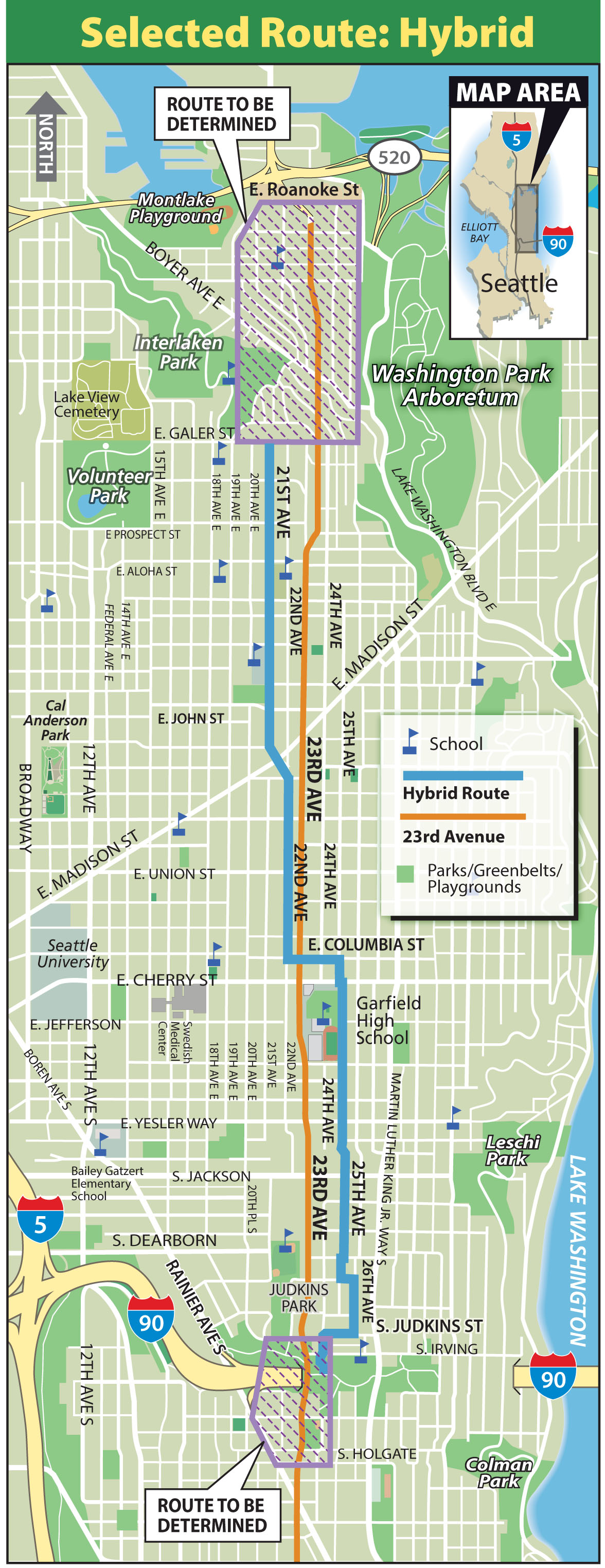
 The city has announced the route for its longest neighborhood greenway yet. The Central Area Neighborhood Greenway clocks in around three miles, connecting from the I-90 Trail to Interlaken Park and traveling through the heart of the Central District, the Colman neighborhood, Miller Park and the eastern edge of Capitol Hill.
The city will work on specific design for the greenway over the next couple months with plans to start construction in June. If all goes according to schedule, it should be finished by December. UPDATE: Only the Jackson to John segment will be constructed in 2014, with the rest of the project coming in later phases.
Planners refer to it as a “hybrid” route because they were originally looking for a route either on the west or east side of busy 23rd Ave, which will be repaved over the next couple years.
However, since the intention of the project is to serve 23rd Ave destinations, a route that crosses 23rd Ave at Columbia was determined to be best. South of Garfield High School, the route will be on the east side of 23rd. North of Garfield, it will be on the west side.
Once completed, it will be possible to bike all the way from Interlaken Park to Georgetown utilizing the Central Area and Beacon Hill neighborhood greenways, which are connected by the I-90 Trail. That’s pretty cool. Here’s the route:
And while hills are inevitable, not a single block along the route will be above a 10 percent grade (the point where many people might choose to dismount and walk).
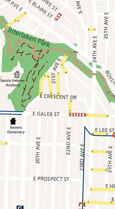
However, Connecting into Montlake using side streets and trails will likely prove difficult or impossible without utilizing segments that are more than 10 percent grade, as the Seattle Walking Map shows to the right.
This is one reason why the city should build protected bike lanes on 24th Ave E either all the way to the Montlake Bridge or at least far enough to connect to the Lake Washington Loop bike route.
For more on our case for protected bike lanes on 24th, see our previous post.
Stay tuned for more coverage of planned neighborhood greenways across the city.


Comments
24 responses to “City picks ‘hybrid’ route for Central Area Neighborhood Greenway”
Question. I’m sure there are good reasons, but why does the trail jog to the east roughly between E Cherry and I-90? Instead, could it stay on 22nd where it would skirt Judkins Park and, ultimately, join with the I-90 trail and finally with the rest of the trail a shown to the south of I-90. (You’ll have to zoom way in on the map to see these details.)
Unless there’s a good reason to deviate, a shorter straight line seems better, plus it connects better with the two parks I mention.
Here’s the evaluation explanation from SDOT: http://www.seattlebikeblog.com/wp-content/uploads/2014/03/2_BOARD_route_eval.pdf
Central Seattle Greenways did push for two full routes (one sticking to east, one to west), but that was shot down. Planners only have funding for one, they said. But, of course, that doesn’t mean they won’t some day go back and complete the west side connection to Judkins Park.
The jog is there because the grades separating 21st Ave and 23rd Ave south of Jefferson or so are pretty steep. A route on 21st is a good through-route, but it’s not a good connection to 23rd Ave destinations. South of Cherry, 25th is more accessible to more destinations (Promenade 23 shopping center, Garfield High School, Thurgood Marshall Elementary, etc).
The crossing at Columbia is also especially useful, since Columbia is a great candidate for an east-to-west neighborhood greenway route and this project will mesh nicely with that one.
But yes, this is why I have been arguing that a nearby neighborhood greenway is no substitute for making the commercial street itself safe for all users, as the complete streets ordinance intends. I do think the Central Area greenway will be cool, but it leaves half of the street unimproved. South of Cherry, the west side is neglected. North of Cherry, the east side is neglected. It’s hardly “complete.”
I ride from Madison to Judkins every day, and it’s better to ride up on 18th until you reach the girls school at E. Columbia, then swing over to 19th, and continue until you reach E. Fir, then swing over to 20th. Then ride 20th to Judkins.
Low traffic, only two traffic lights (because the lights take FOREVER to change) its easier to wait for traffic gaps.
It’s already marked with sharrows, you could stay up on 19th if their were street side crossing buttons, like they have in Portland. But there’s no reason to swing over to 25th if you are coming out of the city.
Depends where you’re going.
The route you describe is essentially Central Seattle Greenways’ favorite route idea (dubbed the “Ridge Route” since it stays on top of the hill from Judkins to Volunteer Park to avoid lots of ups and downs). If you’re headed to the heart of Capitol Hill or Volunteer Park, that’s definitely the way to go.
But that’s different than the Central Area Greenway, which aims to serve residents and destinations near 23rd.
The good news is that the city is planning to work on that route (separate from the 23rd Ave project). Outreach on the Ridge Route should begin sometime this year. Stay tuned or join the Central Seattle Greenways Google Group to stay updated (top right of sidebar): http://centralseattlegreenways.com/
I used to be headed from S. Lake Union, to the I-90 trail now I’m coming out of the retail core of downtown and all other routes suck worse.
Staying up on top of that ridge is the best especially if you are heading all the way past Volunteer Park and on to Interlocken. As you say there are no good routes to the East of it. I think of it as the I-5 for bicycles heading N/S.
Ok, so last night on the way home I rode the bit from Columbia down to 25th from 19th. Then South on 25th with the jog over to 24th and Judkins.
Terrible…..
If you wanted to go to Garfield HS, ok, yeah it goes right by, but with all those cars parked at an angle waiting to pull out, kids texting etc, it’s an accident waiting to happen.
Plus going South, it’s not level, it’s up hill those two blocks of the HS. No reason for that at all, if you stay up on 19th, it’s flat.
Is there any real reason to be one block closer to 23rd? Not in my mind.
It’s too bad the city picked this route. I will never use it, nor recommend it.
Again, Gary, it depends where you’re going. That uphill by Garfield is needed because 23rd goes uphill there. If the route is going to stay relatively level with 23rd, it needs to go uphill with it.
An dangerous spots along the route can be fixed in the redesign. In fact, that’s the point of making it a neighborhood greenway. Any “accidents waiting to happen” can be made safer. Choosing a route doesn’t mean it’s perfect now, it means it could be good.
There are a lot of destinations along 25th served by this route. It’s not just about getting from Capitol Hill to the I-90 Trail. That said, this has been a frustration of mine during this process. The 23rd Ave repaving project was supposed to be a complete streets project, but building a nearby neighborhood greenway is simply not a substitute for safe access on 23rd itself. Every route option fails in some way, either as a convenient and flat through-route or as a route with easy access to 23rd Ave destinations. This hybrid is the best average of those goals, but it doesn’t fully achieve them. Only a true complete street could do that.
This project should be a lesson to the city that a nearby neighborhood greenway cannot be used as an excuse not to accommodate people on bikes on commercial street remakes. Neighborhood greenways are great on their own, but they are not substitutes for safe bike lanes on nearby streets that need them.
“There are a lot of destinations along 25th served by this route.”
Like what? I just drove via google maps 23rd from Cherry to Judkins and saw absolutely nothing I would want to go to via a bicycle. Yes there are appartments on 23rd.
But what you are asking for is to either take the road from 4 lanes to 3, and I could see that would work for me. But I don’t have traffic counts for 23rd, or widening the road another 20 ft to give two 10ft bicycle/cycletrack lanes. And frankly I’d rather the city spent the money elsewhere and left this road as “not cycleable.” Every street doesn’t have to be bicycle friendly for a city to work. Especially when we have more than excellent no traffic roads only one block away. A few lights that trigger for bicycles for crossing on 20th and it would be a perfect ride.
My complaint with this plan is that 25th is the wrong street to turn into a greenway. Looking at the maps yesterday made me think that, and now that I’ve ridden it, I know that 25th is the wrong place. It feels like it got “put over there anyway from “me” ”
But the good thing is that there is no one forcing us to use it. Just another waste of good money but heck, SDOT does that all the time. What else is new?
Looks great overall, but yeah the 21st/Galer terminus is quite the dead end, good for a ride to the UBridge via Interlaken but not much else. If the city isn’t willing to put bike facilities on 24th, perhaps we could have a second greenway split off at 25th/Columbia and run along 27th to MLK/Madison where it could join the Lake Washington Loop into Montlake?
Central Seattle Greenways also suggested this, but project folks said 27th was too far from 23rd Ave to fall into the project scope.
I wouldn’t be surprised if 27th rises to the top of the priority list within a couple years. The city is planning to make the Lake Washington Loop route from the Montlake Bridge to Madison Street into an actual neighborhood greenway next year (study and outreach is scheduled to begin this year). That will leave a fairly glaring gap between the Central Area Greenway and the Lake Washington Loop, and 27th is the obvious connection between Madison Valley and Columbia Street, IMO.
That’s great to hear, I would love to see some calming applied to that route as well. There is a lot of aggressive going-home-hour driving on that (Montlake-Madison) backroadish neighborhood route.
I should amend my previous statement: It won’t rise to the top without a little push from neighbors and street users like yourself!
I agree, too many people drive too fast on 27th and the steep residential streets that cross it (many of which have awful blind spots). This is where neighborhood greenway enhancements can do a ton of good for everybody’s safety.
The other route I’ve taken “just for fun” is to come out of the I-90 tunnel on the West Portal and head North on 29th, then jog back to the East on 31st until going North you hit Cherry, then jog West to 30th and continue North until you reach E. Republican then cross Madison and pick up the Arborium by-pass cycle trail to Montlake Cut.
Again it’s another N/S “freeway” for bicycles ie just sign it for those who want a low traffic alternative to Lake Washington Blvd and the hills are less as you don’t have to re-climb the ridge where LK Wash blvd meets Lakeview Park. (the hairpin turns slow down the cars but you are totally in the blind spot for on coming traffic.)
(What really sucks is that you can’t just stay down along the lake through Madison and cut South in the Arboritum at E. McGlivra… I’d feel bad about trashing a park, but it’s more about that Broadmoore has cut off the access.)
[…] with a goal for the first phase of greenway work to be complete before the end of the year. UPDATE: Seattle Bike Blog has more details and helps clarify that the phase one construction will focus on the stretch between Jackson and […]
Not sure whether this is reading too deeply into simple re-use of existing maps, but it seems unfortunate to me that a route linking to the I-90 Trail uses a map that shows I-90 itself instead of the I-90 Trail connecting to 12th Ave S, and doesn’t show the I-90 Trail east to the bridge.
The south end of the greenway will have some very important connections that this map really doesn’t show very well. Probably just reusing a base map designed around cars, but I hope they’ll have something better to sell the route once it’s built!
Just use maps.google.com and turn on “bicycle routes” and you’ll get a better map for what you are looking for.
Sure, but if I were a public agency spending a lot of money to encourage cycling, don’t you think I should include bike connections on my own maps, rather than print maps of the Interstate and tell cyclists to go try Google?
Greenway groups from Central Seattle and Montlake will explore the crazy hills of northeast Capitol Hill during a family-friendly event we’re calling Silly Hilly. Is there really a family-friendly route for biking or walking from Montlake up to Miller, or is 24th the ONLY choice? Mark your calendars for Saturday, April 26, 2-4 pm. Details coming soon.
Thanks Merlin! The Silly Hilly Sounds like a hoot.
That is part of my bike commute from the CD to UW. I find that 19th Ave E to Interlaken back to 19th Ave E (the steep hill leading to the Greek Orthodox Church) is the best bet by bike. The only bummer is that steep hill. It is only like a block though, so could be walked.
For peds it seems like the park is really nice to walk through during the day.
At the bottom of the hill near the church it would be great to put a Greenway all the way through to Lynn (currently an alley goes almost there, then ends in an awkward quasi-path, forcing a choice to off road up the quasi-path or cut through the Greek Orthodox parking lot, both are sub-optimal).
From Lynn it would be simple enough to shunt over to 18th Ave E which leads directly to the Montlake Playpark. The trail here already ducks under 520 and serves as a heavy commuter route feeding to the Montlake Bridge.
That’s my 2 cents for the lowest-hanging fruit to connect UW to the 23rd Hybrid Greenway while minimizing steep grades. I think there may be some better routes but that they involve more extensive construction and repurposing of land
I would like to make it to the April event, but past history indicates my schooling will likely get in the way.
Thanks again for all your advocacy Merlin!
Montlake to E. Miller??? Seriously? There is a trail in the Montlake park that goes from the bridge to 18th, then cut back on E. McGraw (there should be a path through that cars can’t drive on.)
Or are you wondering how to get up to the top of Capital Hill?
Miller is the Park at 19th Ave E. and E. Thomas St., near the top of cap hill and the currently discussed “Hybrid” Greenway.
If you turn on the terain map for google you can see that the least grade is Madison. Of course it has the worst traffic. However if you ride the Arboritum bypass over to Madison, cross Madison and ride Southwest on what appears to be E. Republican to 27th, then ride West on E. Thomas to 19th. you’ll have the least grade possible. With the other alternative to do as Anders suggested and head over to Interlocken.
I like this route a lot. It connects to two of my former alma maters, Meany Middle School and Garfield High School. Meany is closing, but it will be replaced by Nova, an alternative school (where one of my kids went). All of this is really good. High school kids need a way to get around without taking a bus. It is also nice because these two high schools have worked together in the past (if you are a Nova student you can participate in sports programs offered at Garfield).