
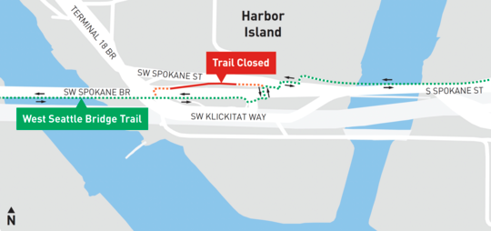
SDOT has closed a section of trail near the east end of the Spokane Street Bridge, effectively closing the trail loop under the bridge and forcing all trail users to use the crosswalks and sidewalks at the intersection of SW Spokane St and 11th Ave SW. The trail will be closed until sometime in April while crews install a new communications line for the swing bridge control system.
One of the crosswalks marked in SDOT’s map was the site of the collision that killed Robb Mason last July. Though the route marked on the map is the most direct route and is commonly used, the trail loop under the bridge is also popular because it allows people to skip using the crosswalks entirely. The construction notice downplays the importance of this trail loop:
“While this work occurs, we will temporarily close a trail spur that branches off the main West Seattle Bridge Trailway. The impact to people who bike, walk, or roll in the area will be minimal. Our project closure site will not affect the main trail over the Spokane St Bridge, or the primary bike route between West Seattle and Downtown used by most people on bikes. Instead, we will be closing a section of the trail that provides an optional loop around the foundation of the Spokane St Bridge used by some bikers.”
— Advertisement —
I found this determination somewhat surprising since I always use the loop, and I thought it was the main route. While the trail loop has extra distance, you don’t need to wait for the walk signal or worry about car and truck traffic. Those crosswalks have always felt sketchy and in need of more safety enhancements. For example, people driving eastbound across the bridge can take very fast right turns due to the wide turning radius.

Perhaps the city could do something to tighten up that turn to encourage slower turns across the crosswalk. The Spokane Street crosswalk is also placed an awkward distance from the intersection due to the rail line there, and it crosses two lanes in the eastbound direction for seemingly no reason. There is only one lane eastbound across the bridge, and the street goes back to one lane shortly east of the crosswalk. It’s almost at though that second eastbound lane exists only to make the crosswalk more dangerous. Seattle’s Vision Zero data shows that the vast majority of people killed while walking or biking happen on streets with more than one lane in the same direction. SDOT could tighten that crosswalk up so it crosses only one lane in each direction, which would dramatically reduce the time users spend exposed to traffic and remove the ability for people driving to use the second lane to make a dangerous pass. This change could also help create some space to tighten up the turns and create a less awkward and squished area for trail users.
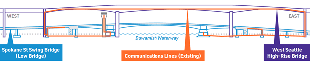
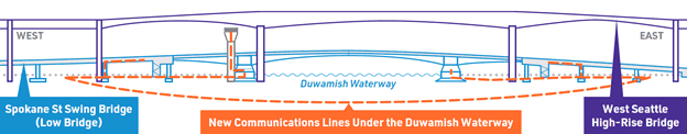
The construction work will move communication lines from the upper bridge to a new underwater route. The work is a “proactive” effort to “decouple the low bridge from the high bridge,” according to SDOT. Not exactly a vote of confidence in the high bridge, which underwent emergency repairs after serious cracking was discovered in early 2020. The Spokane Street swing bridge has its own troubled history due to an unreliable opening mechanism.


Comments
7 responses to “Alert 1/25–April: Section of trail near east end of Spokane Street Bridge closed + Ideas for making the crosswalks safer”
This is super irritating that they are being so cavalier about the closing. This is the major/preferred route and in my experience only a select few brave souls dart across traffic or with even fewer using crosswalks. They are begging for a biker/vehicle collision with this idea.
More people should use the southern sidewalk route that begins at Marginal – that route dodges the entire north section and need to cross at the crosswalks.
I wonder how much it would cost to build a bike pedestrian bridge from one side to the other?
lol I’m one of the dummies that uses the green line route :). In my defense I might cross 5-6 times a year and don’t ride with groups often, so just didn’t realize the other route was there. I’ve always hated those crosswalks, the super-tight 90*+ turn makes both of them difficult to see traffic until you’re right on the crosswalk, and because you’re parallel to the road I expect basically all drivers to engage in ye olde “didn’t see them!” for any cyclists approaching, so I treat it as if the crosswalk doesn’t exist. and yes, even in my few crossings I’ve definitely watched trucks blow through that crosswalk where I’d have been if I trusted it.
I could go a little extra distance to skip some of that? heck yeah, count me in.
so, I don’t know how common it is, but even if they’re right that a lot of people take that route, maybe that’s only because the other option is obfuscated and signage directs people the more dangerous way.
The loop route doesn’t skip the crosswalks across the exit lanes where you have to negotiate with vehicle traffic one lane at a time, it only skips the signal-controlled crosswalks at Spokane/11th. I’m glad enough to skip those, at any rate. I’ve never seen much traffic around there or even any more dangerous driving than anywhere else but it kinda gives me bad vibes. Maybe it’s seeing the wide-open lanes and hearing the freeway noise nearby…
Personally, I don’t find the crosswalk route so bad. The light normally changes very quickly when requested. So I’ve always found it reasonably safe to cross.
If I had kids or inexperienced riders with me, I might prefer the loop route. Don’t know.
The loop route should be SDOT’s preferred route! It works great except it needs better signage, and lighting at night at the underpass. Someone asked for a bike bridge. We already have a working bike underpass! The crosswalks are dangerous. Too many drivers blow the lights. Two bike riders have been killed crossing there in the last few years. I use the crosswalks at night when the underpass is a bit spooky, but never cross at the crosswalk without making sure that drivers have come to a complete stop.
The things that need improvement are the wiggles at the Port’s Terminal 18 driveway and the crossing of the westbound lane that peels of off Spokane Street just before the trail crossing to become SW Spokane Place.
In 2020 when the high bridge closed, West Seattle Bike Connections gave SDOT a number of ideas for safety improvements to slow down vehicles and make it safer to cross there.
One is to add speed humps or raised trail crossing on SW Spokane Place. Another is to move the 11th Ave SW / SW Spokane Place traffic signal eastward to the trail crossing. That signal at a rarely-used street and rail crossing is almost always green and is visible to drivers approaching the trail crossing at speed. It makes it appear to a driver that they have the green to go without need to look for people crossing.
We also submitted a Your Voice Your Choice application for these in 2020. Two deaths and several injuries seems like it should be enough to make the case for action by the City. More people will be riding this route once the East Marginal Way S Project is completed.