
The intersection of Rainier Ave and MLK Way is big, dangerous and works poorly for everyone. Running next to a high school, a light rail station and a growing number of other destinations, the city and neighborhood have been studying solutions for at least 15 years.
Well, the city’s latest plan will be different, according to presenters at a recent open house. Not only does the city have a bold new idea for a long-term redesign, they have also identified short-term and mid-term improvements that could finally add some high-demand crosswalks and shorten signal cycles for everyone.
The project — which has the extremely non-descriptive name “Accessible Mount Baker” — does not have funding for any large changes yet, but it could have a good shot at funding if voters approve the Move Seattle levy in November.
First, let’s rewind.
How did this intersection get so terrible?
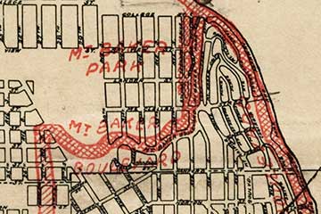
A historic Olmsted boulevard connection between Cheasty and Mt. Baker Boulevards was severed during the 20th Century as traffic engineers from the city and state widened Rainier Ave and MLK (then “Empire Way”) to carry more and more cars. Spots where people could walk or bike across the street were scrubbed to better facilitate traffic flow. But it could have been worse. Empire Way was even slated to become an elevated freeway until neighbors fought and stopped the R.H. Thomson Expressway.
The park-like boulevard that defined the area was cut off from Cheasty Boulevard and lost most of its luster, at least in this part of the neighborhood. To “maintain” that walking connection, a long elevated walkway with steep approaches was constructed. The steep spiral ramps to access the walkway are too steep for easy biking or for people with mobility issues, and many others (like many Franklin High School students) choose to run across the street rather than climb the walkway.
And the intersection they have to cross is terrifying. It’s huge and on an obtuse angle that allows turning cars to pick up a fair amount of speed. Here’s what it looks like today, via Google Street View:
Having two streets of this size intersecting in the middle of the neighborhood doesn’t even work well for people driving. To facilitate all the turns, there are three signal cycles rather than just two. This adds time to everyone’s trips.
Worse, it’s very dangerous. There were more than 250 collisions reported in just this couple-block area between 2010 and 2013. That’s a crash every four days. Many of these collisions involve people on foot.
 But it doesn’t need to be this way. The city’s latest plans would attempt to make the intersection safer, reduce delay at the traffic signal and make it easier to walk across the street without the elevated walkway.
And eventually, the plan could even restore Mt. Baker Boulevard to its former glory as a walkable, bikeable neighborhood centerpiece.
Small changes that can happen now
But first, here’s a look at what the city could do as soon as this year 0r next:
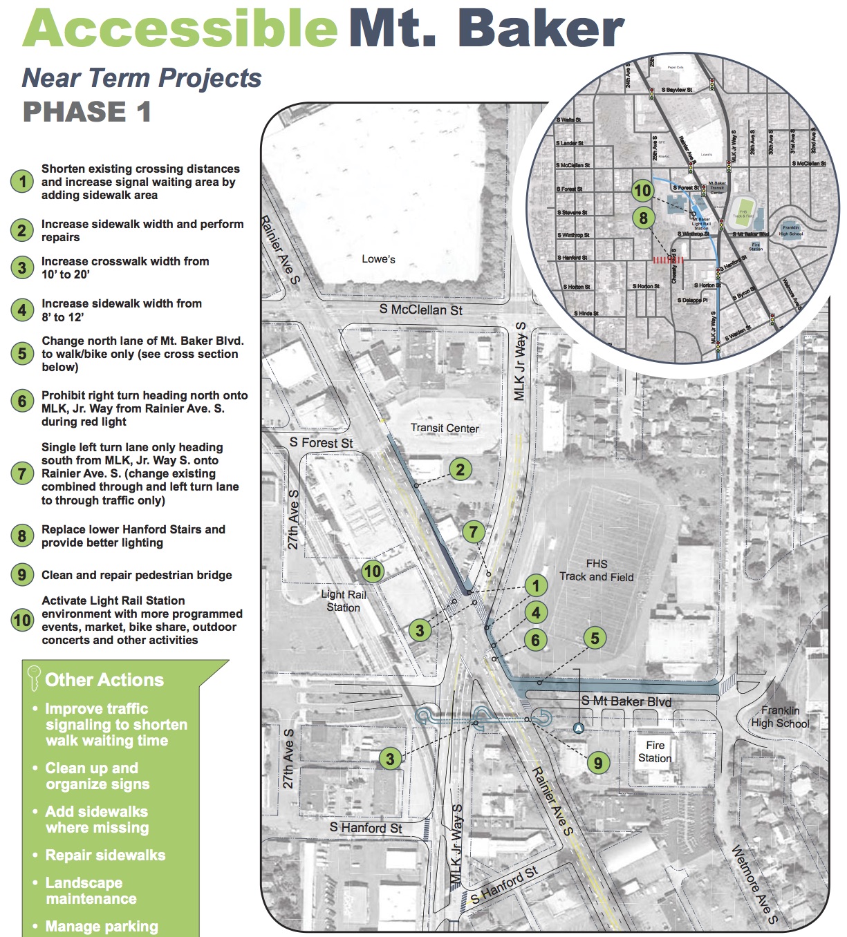
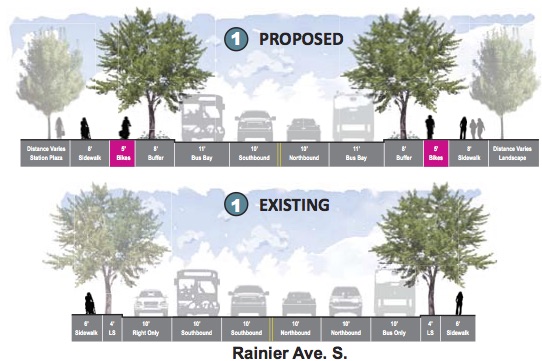
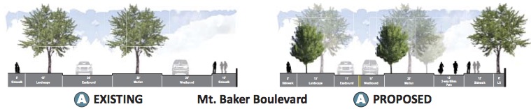 It may not look like much on the map, but it’s the start of the new vision. Today, Mt Baker Boulevard has two ridiculously wide lanes separated by a planted median. The lanes are so wide that the city could put both directions of general purpose travel on the south side of the median, then use the north side of the median to create a new protected bikeway and expand the walking space.
The city can also repurpose an unused bus lane on Rainier to widen the sidewalks and increase the space at corners for the crowds of people waiting to cross the street.
But with more funding, they can do all that and more:
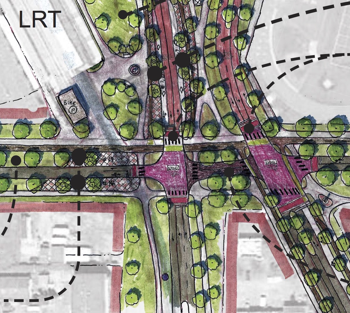
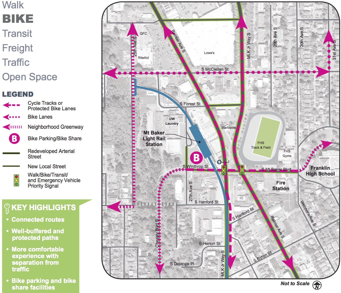
 The most exciting part of the “near term” project list is a new, badly-needed crosswalk from the Franklin High School field across Rainier Ave (marked #3 in the map). While the elevated walkway would remain, this crosswalk should allow people to safely make this crossing at-grade.
This is the essence of the newer, smarter SDOT approach: Rather than create unrealistic pedestrian pathways, then get angry at (or even punch) people who don’t follow the intended path, the city should observe how people actually want to use the space and make it safer for them to do so. Traffic engineers, especially in the era this walkway was created, had a history of trying to fight people’s natural desire lines through a public space. That style of engineering can have devastating consequences, as all the people injured crossing this street know all too well.
The city would also extend the south triangle of the intersection to make all the crosswalk distances shorter. These changes are thanks to eliminating all left turns from MLK, which would also allow the city to cut an entire signal cycle, reducing wait times for everyone. People turning left from MLK to Rainier would have to do so at a different intersection or would reroute to take MLK rather than Rainier if possible for their trip.
This phase of the project is also an opportunity to add a bike lane on Rainier Ave between Mt Baker Boulevard and MLK, which the Bike Master Plan identifies for protected bike lanes some day.
The big, long-term vision
 But to truly restore the neighborhood center, create comfortable walking and biking connections and ease traffic headaches, the city hopes to dramatically redesign the intersection by, well, getting rid of it entirely. Southbound Rainier Ave would turn into southbound MLK, and vice versa.
The changes would allow the city to reconnect Mt Baker Boulevard for people walking, biking and taking transit (private cars would not be able to make the connection, but Metro’s high-performing Route 7 bus would, as would emergency vehicles and people biking and walking). This means lots of new public space for the area, which will see a lot of higher-density redevelopment in coming years and decades.
By reconnecting Mt Baker Boulevard, the city would also be reconnecting the Olmsted-designed route from Beacon Hill to Lake Washington, a beautiful vision for the area.
These changes would not only revolutionize the Mt Baker neighborhood, but they would forever shift traffic patterns in Rainier Valley.
MLK north of this intersection is fairly low-traffic. Rainier Ave south of this intersection carries lots of regional traffic and goes through the heart of Rainier Valley, passing through many neighborhood business districts. By routing most regional and freight traffic to MLK south of Mt Baker, Rainier Ave could be more focused on safely serving local traffic and people going to area businesses. MLK, meanwhile, was rebuilt when light rail was installed to handle more traffic than it carries today.
Planners think these changes would be especially good for freight movement, which does not really work well on Rainier Ave today.
Bike lanes on MLK and Rainier
 These changes would also free up space to add bike lanes to both MLK and Rainier Ave. This is a huge, bold vision for a bikeable Rainier Valley and the Mt Baker neighborhood. Most of the traffic congestion in the area has less to do with road width and more to do with this poorly-performing intersection. By removing the choke point, the city could also more easily add bike lanes to both these vital corridors. Simply put, this would change everything for bike access in south Seattle.
It’s not hard to see how this project could connect into bike lanes created as part of the current Rainier Ave Road Safety Corridor Project that starts just south of Mt Baker.
You can see planners’ presentation slides in this Powerpoint or check out all the display boards in this PDF.


Comments
30 responses to “Mt Baker intersection redesign could revolutionize transportation in South Seattle”
Wow. Its really amazing how activating one intersection like this could really connect whole neighborhoods and create new community space in South Seattle.
Big kuddos to the designers who thought this through and the bosses that supported them!
i expect this is another disingenious article about fixin something is is already funded to be ‘fixed’ or doensn teed fixing. if the students arent going to cross the road properly no new paint job will fix that. granted, i coulndt see any bike lanes on ranier and mlk but it looks like from the residential POI 25th or 30th could provide back’do access via bike to many mlk and ranier shops and businesses. the restore urban values comment seems stupid. there is light rail, crosswalks, and over pass walkways….looks plenty urban to me, and lots of trees to boot. if anything making it more car safe would be cheap i suppose.
i guess the biggest pedestrain car conflicts come at mornign rush. 3pm schools out rush and evening commute rush…..put in several speed humps for cars as you approach the intersection to tame car speeds.
If you don’t think this intersection needs fixing, than you my friend are a special kind of stupid.
I came across the intersection once since moving here, living about five miles away. I remembered it enough to know it prior to seeing the google maps. It is one of the most broken intersections in any city I’ve seen, and they made a mess of every city in the 1950’s.
I have to drive my car through this intersection all the time. I live in the area, shop in the area. The long-term idea is AWESOME. I am very, very, very supportive. I’ll show up to the meetings and say so. About time we re-imagined this area as something other than a loud, dangerous, polluted, litter-strewn runway, which is what it currently is.
One more thing… this really is where transportation in SE Seattle goes all wrong. It stems from this intersection (MLK/Rainier) and associated intersections/attractions. The effect on traffic safety all the way down the Rainier Valley starts with how the light timing and lane design at this intersection preferentially puts the vast majority of traffic on Rainier rather than MLK.
Higher volumes lead to driver frustration, with rapid merges and turns causing accidents and deaths all the way down Rainier Ave S. Meanwhile, a brand new, modern signal, 4 lane street with a 5mph HIGHER speed limit gets the minority of traffic from the intersection. Going north, again, MLK is under used as a N-S route compared to Rainier, and Rainier is overcrowded, tense, and dangerous. Pedestrians and bikers would love to use the flattest, most-direct route, but don’t because it’s a dirty, loud, exhaust ridden, litter strewn wasteland with poor setbacks and worse sidewalks.
It all originates from how traffic is distributed from this intersection. People are dying on Rainier – way, way too often. It has to stop. We have to do something bold to circulate traffic better and create more space people actually want to be in.
The better this intersection is, the more likely people are to use this LINK station. As a pedestrian I felt like I was in car wasteland walking down there.
reconnecting mt baker, looks a bad idea. its a grassy little street thru quaint houses and right along side the schoo, heck, it looks to be part of the school grounds….would reconnecting it make more cars pass thru on it??
if cost is no object rename and tear it all down. what are some significantly cheaper options to improve the intersection??
You should take out the snide parenthetical about an SPD officer (not an SDOT employee) punching a student in 2010. He didn’t punch her for jaywalking, he punched her for physically interfering with an arrest. The inappropriateness of his use of force has already been decided, but your reference to the event is extremely misleading.
It’s not misleading. It started as an emphasis patrol to try to get students to stop crossing at the exact location where this project would add a crosswalk. Basically, to try to use police stops to get kids onto the pedestrian walkway (it didn’t work). That seems rather relevant.
Part of the SPD use of force report by the Feds noted the fact that many instances like the student-punching one started as low-level stops, like jaywalking, that escalated into use of force.
Policing people’s behavior in a poorly-designed walking environment is simply the wrong way to fix the problem. If the road just made sense for the way people naturally want to move through the area, this wouldn’t have ever been an issue.
And while I get that SPD and SDOT are not the same agency, they are both part of the city and the traffic system.
Wallingford/45th is a far from ideal scenario for a redesign, and to me a shabby standard of comparison. Peds don’t get hurt there because busses and cars don’t move. It also sux for biking.
I bike often for transportation and fitness–yes, year-round and regardless of the weather–but I’m not convinced that getting rid of an expedient, efficient network of driveable roads–as many of the road diets (NE 75th) do–is either necessary or good. Nothing wrong with parallel cycling and driving grids–not every improvement in bike infrastructure needs to be at the expense of getting around by car. So, I would more strongly support making MLK the ped-n-cycling paradise and Rainier a safer, but still efficient car-path. Yeah, I’m also fantasizing about a denser, more light-raily future too, but with service cutting out shortly after a child’s bed-time, and the risk factor of biking home after that being too high for most people outside of the heroic 18-25 y-o males demographic, cars are still a good, necessary option.
I think you’re overestimating how efficient these four-lane roads really are.
For example, see our recent report on NE 75th Street. It actually made the street more efficient. After the changes, more people drive there and the average time it takes to travel the length of the street actually went down barely (effectively unchanged, since the change was so small). Speeding is down, but the average speed through the corridor is up because there are fewer delays and stops.
http://www.seattlebikeblog.com/2015/03/19/after-ne-75th-st-safety-project-speeding-way-down-safety-way-up-traffic-delays-down/
I get that this is counter intuitive, but more lanes does not necessarily mean more efficient traffic in an urban environment. Plus, all those collisions jam up traffic pretty bad, too. Making the street safer and more predictable makes it more efficient.
Four-lane streets were intended for rural areas and divided highways, not cities where people need to make turns constantly and parallel park and walk across the street or bike to the store.
If 45th had four lanes instead today, it would be absolute carnage. But that taps into a social justice issue: Why does Rainier, which carries fewer cars per day than 45th south of Mt Baker, still have such a dangerous design today? Wallingford residents had their street changed in the 70s and have had decades with fewer deaths and injuries in their commercial district because of it. Why wasn’t the same done for a very similar road (traffic volumes, commercial activity, busy bus routes) in Rainier Valley? That’s where you should steer your outrage.
Don’t buy the line that cars are losing anything in these changes. Most of the safety benefits go to people driving. That might not seem like a big deal until it’s you or someone you love in one of those collisions.
Word. This ^^^. 75th is better as a 3 lane street than a sorta 4-lane street. Massively safer, slightly more efficient, simpler to navigate.
If I recall, MLK used to be SR 900, Rainier used to be SR 167, and Rainier north of this intersection was part of 900, not 167 (and I think before the floating bridge was built 900 was the former route of US 10). Everything old is new again? (And the fact WSDOMA was in charge of these roads should tell you all you need to know about why they’re so car-centric, not that the city was ever entirely innocent…)
walk up and over the street…seems easy. i expect the physics is taught at the school too. more force runs over less force.
sure it could use some tidying up but are there any alternate plans on the table for this location at less cost?? where they can they be found??
Spoken like someone who’s never done it, isn’t from the neighborhood, and is judging everything through pictures and google earth.
The bridges are terrible, too steep, time-consuming, and underused – for a reason. If those bridges were roads for cars, people would have been howling for a better solution since their construction.
I live in the neighborhood and I use this pedestrian bridge all of the time. The only reason the students don’t use it is out of pure laziness. It is not that steep and functions well. Why don’t we just put an escalator there so the kids don’t have to walk at all!!
I love the long term vision! It’s been a while since I’ve left a public meeting being legitimately wowed. Looking forward to hearing how the traffic modeling turns out.
Agreed. Awesome plan, really, really hope it comes to pass. Keep going to the meetings and filling out the surveys and saying you love it!
This is damn awesome and must be done. I live in the interstitial zone between mlk and rainier north of there and that is the choke point of death for that region. You would def need to expand the mount baker transit center there to allow for a major transfer for the 7, 8, 9, and 48 but it could be done.
Also I have heard word that the Lowes is selling out to become a mixed use high rise like some of those down towards the safeway. That could be a major anchor to justify this!
[…] Baker redesign: The intersection at Mount Baker Station in the Rainier Valley could see a huge, sweeping redesign; one that the neighborhood absolutely […]
[…] http://www.seattlebikeblog.com/2015/04/01/mt-baker-intersection-redesign-could-revolutionize-transpo… […]
This new thinking is welcome, really welcome.
[…] from the Bike Master Plan money and $2 million from the Peestrian Master Plan money to go to the Accessible Mount Baker project. Sponsored by […]
[…] from the Bike Master Plan money and $2 million from the Pedestrian Master Plan money to go to the Accessible Mount Baker project. Sponsored by […]
[…] station, the Northgate Pedestrian Bridge, Vision Zero, Bicycle Master Plan implementation, the long overdue retrofit of Mount Baker Station, and rechannelizations of hostile arterials such as Aurora, Rainier, and Lake City […]
Solid thinking this.
Forcing un-motorized traffic above or below the road theoretically makes traffic move – but people have never used the grade separated crossings. Look at the new bridge at UW around a game – people are crossing Montlake at grade. 45th in Wallingford is a low-speed backed up facility – but it works as such. It move a huge volume. Now if we could just eliminate the parking along it and introduce bike lanes I would be happy. The long-range plan for MLK/Raineer looks great, and the short-range steps look to be int he right direction.
[…] As we’ve reported previously, SDOT has a very promising and radical idea for fixing the problem, and you can weigh in on the biking and walking elements of the plan at an open house 6–8 p.m. Thursday at King’s Hall (behind Mount Baker light rail station). […]
[…] general plan hasn’t changed since our previous report, but the design concept has gotten more specific and complex traffic analyses have shown the […]
This is never gonna happen. Going on 20 years now. Just using tax payers money to do designs and have community meetings. These people need to be held accountable. This is ridiculous 20 years!