
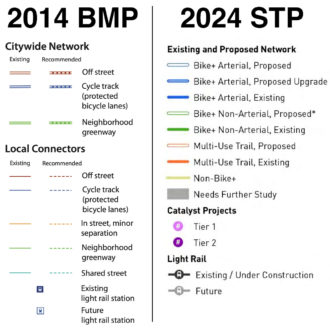
Mayor Bruce Harrell’s proposed Seattle Transportation Plan (“STP”) is now in the hands of the City Council, who can make some final changes before adopting it as official city policy. The STP will supersede the 2014 Bicycle Master Plan, so it’s important to take a close look at its vision for the next 10–20 years of bike improvements across the city. To do so, Seattle Bike Blog will post a series of six stories focusing on different areas of the city. You find other areas as well as other STP-related stories through the 2024 Seattle Transportation Plan tag.
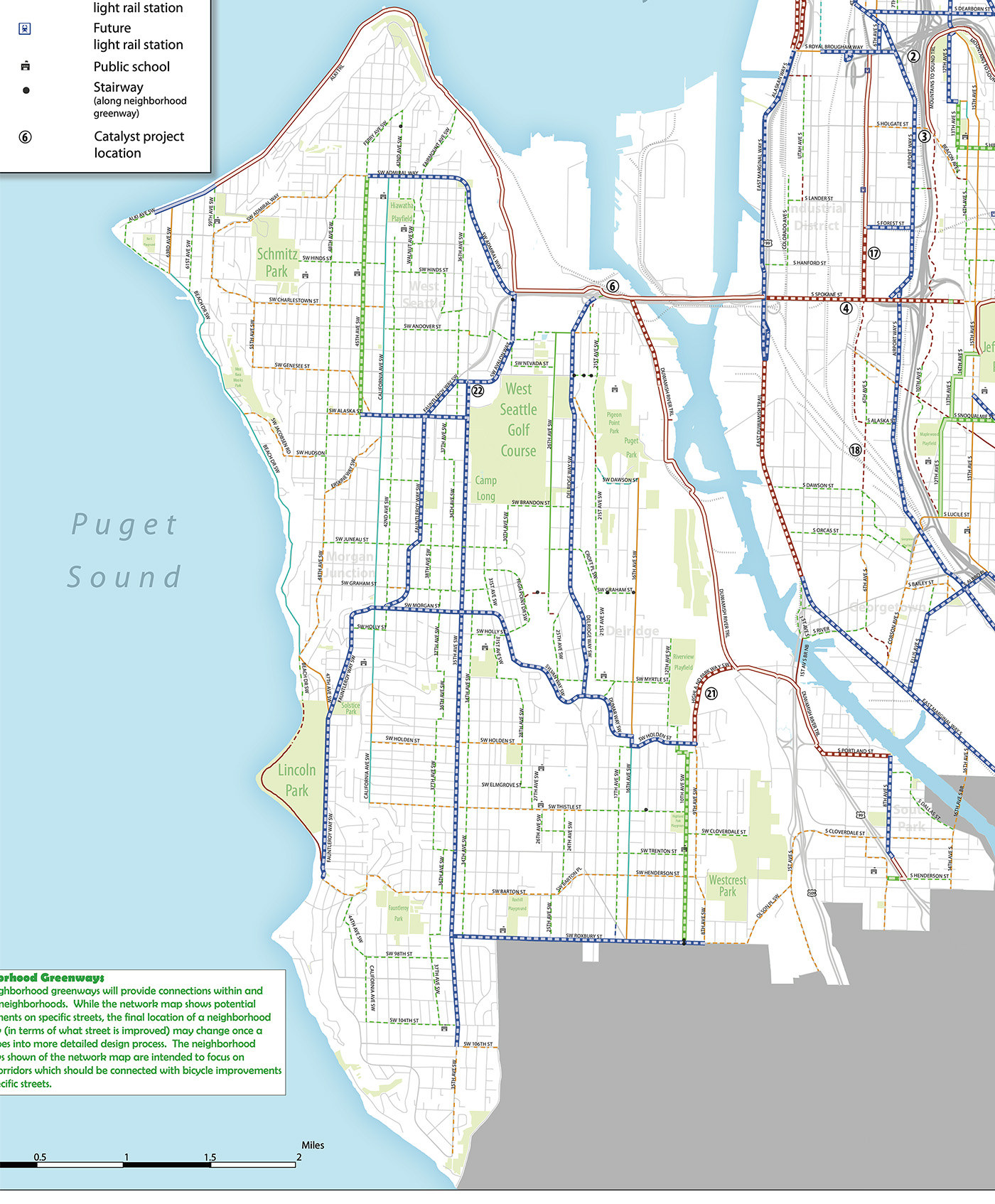
Few other neighborhoods in the city got a bigger upgrade from the 2014 Bicycle Master Plan to the proposed 2024 STP than West Seattle. This is in large part due to the neighborhood getting kind of a second-rate treatment in the 2014 plan. Where the 2014 plan left vital gaps with little or lackluster proposed infrastructure—such as paint-only bike lanes or sharrows on SW Admiral Way, Beach Drive SW and 16th Ave SW—the 2024 calls for protected bike lanes.
The community group West Seattle Bike Connections (“WSBC”) has been very active in trying to provide feedback on the bike elements of the STP, and a good number of their top priorities did make it into the document. But they have concerns about whether they are listed high enough on the priority list to actually happen.
“We were happy to see these projects that are our high priorities on the catalyst list,” wrote Don Brubeck of WSBC in an email:
- #5 SW Highland Park Way, connecting the Duwamish Trail to Highland Park
- #7 Sylvan Way multi-use path connecting Delridge to High Point and Morgan Junction
- #13 and #14 at the Alaska Junction and West Seattle Triangle for access to planned light rail stations and WS’ urban center.
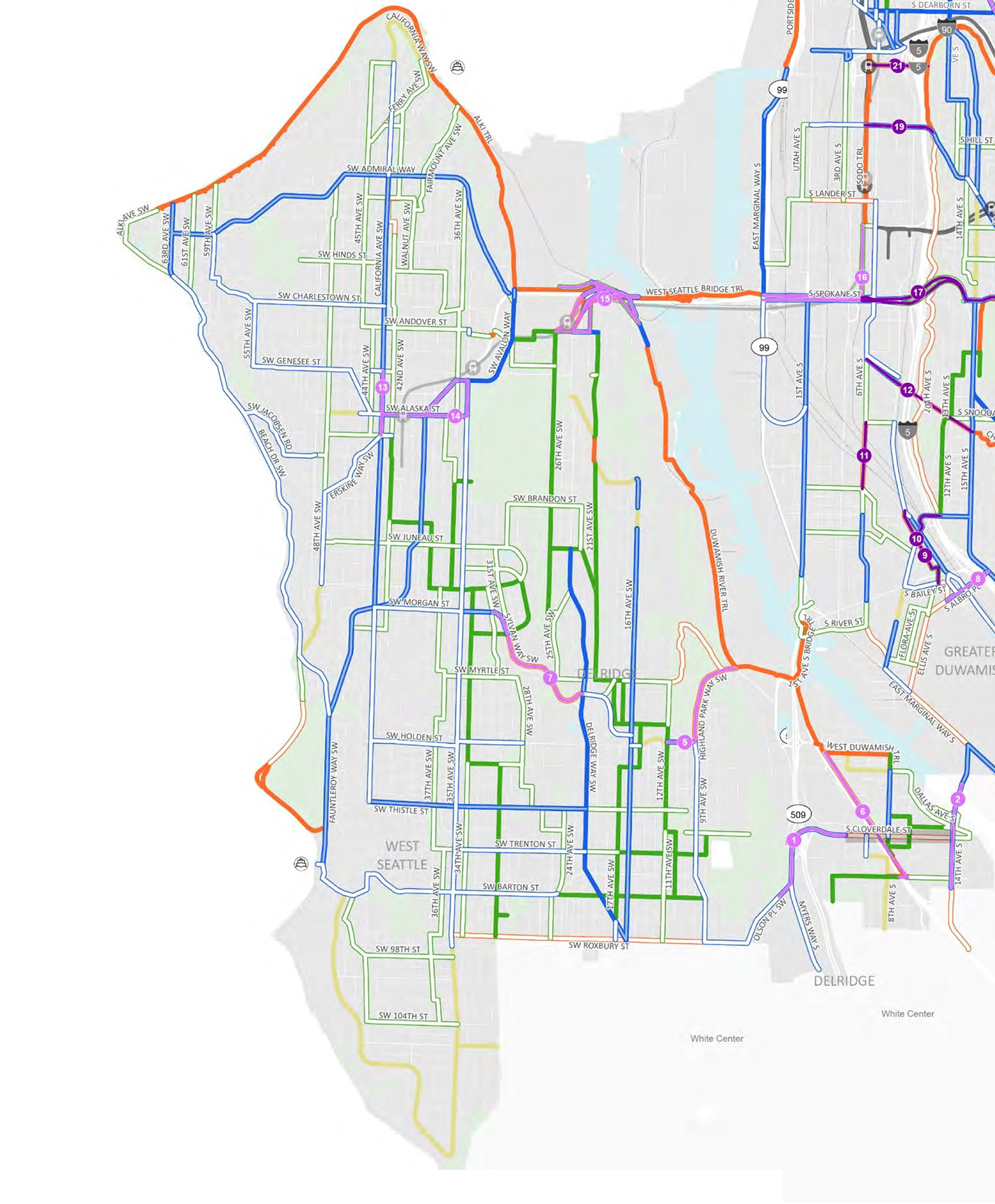
They also scoured the “large capital projects” list (Appendix A) to find more of the group’s “top and medium priority routes” listed:
- #41 Fauntleroy Way SW from SW Morgan to the Fauntleroy Ferry Terminal.
- #42 Fauntleroy Way SW Boulevard project from SW Edmunds to SW Avalon (already 100% designed, subject to light rail design)
- #49 Highland Park Way SW multi-use trail (same as catalyst #5?)
- #64 SW Orchard/ Dumar SW
- #76 Sylvan Way SW (same as catalyst #7, and together with 49 and 64 creating the South Park to Highland Park route)
- #69 SW Roxbury St multimodal project, a critical east-west serving the southern end of West Seattle and north edge of White Center.
- #11 16th Ave SW
- #19 SW Admirał Way.
However, they are concerned that of their community group’s top priorities, only Fauntleroy Way SW is currently listed as a top tier capital project in the STP. They also question how the plan determines project priority, noting some odd scores. “Projects for Admiral and Alki have higher equity scores than projects serving South Delridge and High Point,” said Brubeck. “A project that is an industrial drive on Harbor Island has one of the highest equity scores in the city…What criteria were applied? It all looks capricious and arbitrary.”
Seattle Bike Blog is working on a story about how the plan calculates priority, so stay tuned. This plan is huge, so it’s taking me a while to chew through it. But priority is the secret center of power within this plan because it likely determines what will actually get built with our limited funding and what will remain little more than a line on a map.
SoDo
Leaving most of SoDo out of the Bicycle Master Plan was a mistake. The 2014 plan pretty much only called for protected bike lanes on the perimeter streets: E Marginal Way and Airport Way S. Shortly after, however, Airport Way was quietly removed from the city’s project list, supposedly due to concerns from WSDOT that they wanted to use the road as a potential I-5 detour route. That is a terrible reason to maintain dangerous excess capacity on this roadway and to fail to make it safe for all road users, but it was the excuse that SDOT told the Seattle Bicycle Advisory Board about a decade ago (I don’t remember the exact details and couldn’t find it in my old notes). Regardless, by taking out one of the only significant bike improvements in all of SoDo, the 2014 plan essentially called for no changes in SoDo other than the E Marginal Way rebuild.
Unfortunately, SoDo has increasingly become the site of far too many traffic deaths, especially dangerous for people on foot and bike. We have to make SoDo’s streets safe for everyone, and we can do it while supporting industrial businesses.
The biggest addition in the 2024 plan is the inclusion of protected bike lanes on 1st Ave S between Georgetown and S Spokane Street, though these unfortunately come at cost of losing the proposed trail on E Marginal Way south of Diagonal Ave S or so. The plan also includes this confusing bike lane arc from E Marginal to 1st Ave S with no explanation of what it means. Is it indicating that they don’t know where the connection will be? Or maybe we’ll all get free helicopter rides. Either way, it’s extremely exciting to see bike lanes on this section of 1st because we already experienced them briefly in January 2023, and they were amazing.
However, it’s frustrating to see the proposed 1st Ave S lanes stop at Spokane rather than extend north to at least the Lander Street Bridge if not all the way to the stadiums and Pioneer Square. Even though on a map it looks like E Marginal Way and 1st Ave S are close, there are very few opportunities to cross between them. They may as well be on different islands. 1st Ave is also packed with desirable retail destinations in addition to workplaces, and people need to be able to get to them safely. Connecting to the Lander Street Bridge will also help folks use their bikes to connect to SoDo Station and the SoDo Trail. There is no connection from E Marginal Way to SoDo Station (I strongly doubt the proposed Colorado/Utah route could ever meet the standards of a “bike+ neighborhood greenway” and should not be considered an alternative to 1st Ave bike lanes). 1st Ave S is extremely wide with six or seven lanes, and it is a very scary place to ride a bike or cross the street. Extending the 1st Ave protected bike lanes would be a very worthwhile change to the STP.
The proposed STP also includes protected bike lanes on Holgate Street, which has been the site of a high number of fatal collisions involving people biking and walking. It desperately needs a serious safety intervention, so it is great to see that line included. Perhaps councilmembers could make sure it is a high priority project.
The SoDo Trail and S Spokane Street catalyst project (#16) also holds a ton of potential, though the plan should also call for a lower-budget on-street version of the Spokane segment that could be completed in the near-term to connect with the soon-to-be-constructed route on 6th Ave S. If the budget is there to make the catalyst project happen soon, then that’s great, but this connection is too important to place entirely inside a larger project that may not happen.
The proposed STP also includes some significant improvements in Georgetown and South Park, including protected bike lanes on 14th Ave S in South Park and a bike connection across SR 509, a freeway that is begging to be removed entirely. The plan also calls for protected bike lanes on Airport Way through Georgetown as well as some new intra-neighborhood connections.
Notice anything else that I missed here? Let us know in the comments below.


Comments
2 responses to “The 20-year bike plan for S/SW Seattle: West Seattle and SoDo”
One spot I always take an interest in is connections south from the 26th Ave Greenway… you should be able to connect from the Greenway to destinations west of Delridge and south of Orchard (schools, parks, Westwood Village) without doing anything too crazy (going way out-of-direction map-wise, going way out-of-direction elevation-wise, going way out-of-direction traffic-wise).
Having a one-way bike lane on Delridge means there’s an OK route southbound but not northbound. Real support for two-way bike movements along Delridge from Myrtle to Webster is the minimal solution that lets you do the rest on reasonable side streets and the plan shows they plan to improve Delridge from Myrtle… only to Orchard. Bizarre.
I’m looking forward to the designs for making California and 35th Ave SW “Bike arterials.”
Other small items of note
1) The east-west SW Brandon spur that crosses Delridge and connects up to 21st, its unclear how this is possible as due to the topography, 23rd to 21st is a 100ft slope. Google street view and satellite show this impassable by car.
2) There is a 1 block area on 16th Ave SW that is “non-bike+” but is a bike arterial both north and south of that. However, further north it again becomes non-bike to get to 21st. This is their dream scenerio and they cant even dream a better answer.