
Once amended and approved by the City Council, the Seattle Transportation Plan (“STP”) will supersede the 2014 Bicycle Master Plan (“BMP”). So how does it compare to its predecessor?
As we noted in our previous story, the 2014 bike plan was a very strong document, especially for its time. And its fingerprints are all over the bicycle section of the mayor’s proposed STP. Mayor Bruce Harrell submitted the plan to the City Council last week, and the new Transportation Committee had its first briefing about it this week.
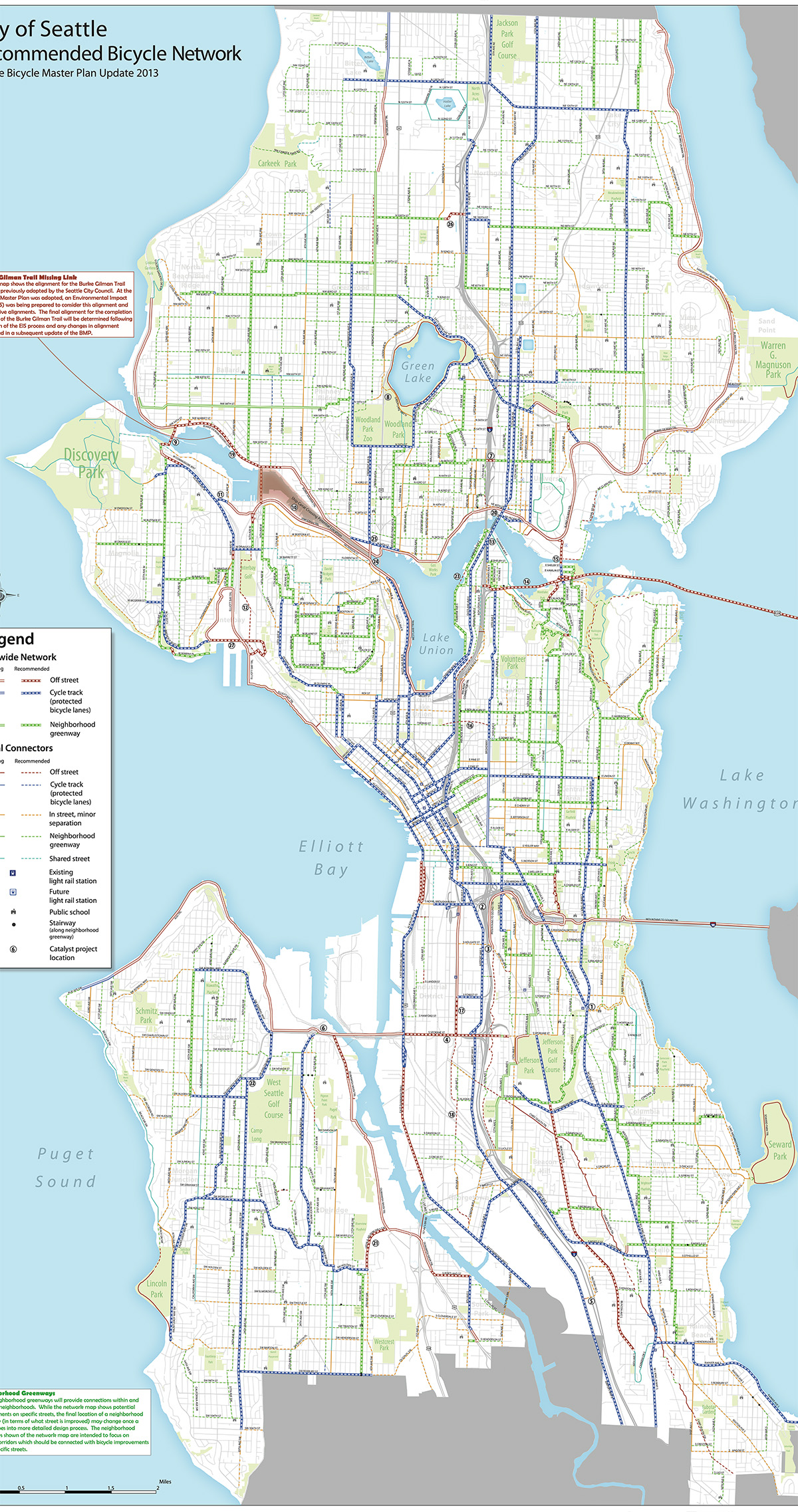
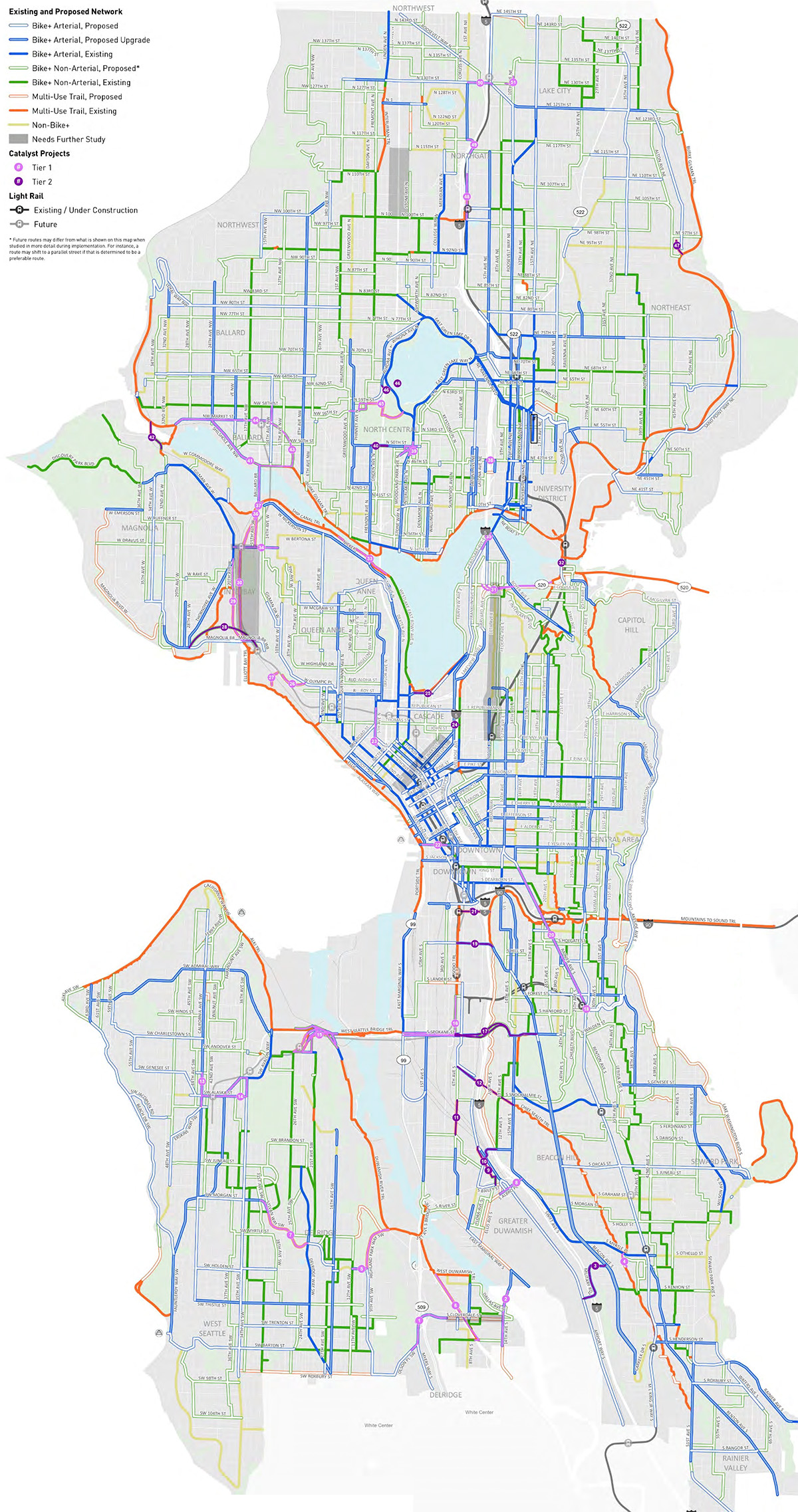
To help you see for yourself how the planned bicycle networks compare, I lined the maps from the two plans on top of each other to create the handy tool above. Move the slider left and right to see the changes. And let us know what you find in the comments below.
The most immediate high-level observation here is that a lot of the map changes are positive, though there are definitely some needed improvements and clarifications. Many streets that were slated for paint-only bike lanes (or uphill-only “climbing lanes”) in the 2014 plan have been upgraded to protected bike lanes in the proposed STP. This change reflects how SDOT has mostly been operating anyway since many of the streets slated for painted bike lanes in the old plan were actually too busy for that to be an appropriate treatment (15th Ave S on North Beacon Hill is a good example).
Some streets marked with a yellow line, however, now fall under a new category: Non-Bike+. “Bike+” is a new term in the STP that encompasses any bike facility designed to be safe and comfortable for people of all ages and abilities. So “Non-Bike+” streets are places where the plan acknowledges the need for a connection, but it is proposing a stub-standard facility such as paint-only bike lanes, a bike lane in only one direction or sharrows. The STP specifically states that it does not preclude these streets from getting Bike+ facilities if it is later deemed possible, but the plan estimates that the “right-of-way is so constrained that an AAA bike facility is not feasible.” We will discuss specific examples when we go neighborhood-by-neighborhood in future posts, but the most glaring and obvious one is Seward Park Ave S between Seward Park and Rainier Beach.
Both maps include numbered projects, which denote “catalyst” projects. These are projects of unknown cost and feasibility such as new freeway overpasses or major street remakes. They may also be projects that require coordination with other agencies or partners. The city does not expect to complete these all in 20 years as part of SDOT’s regular work, but they are listed in case the opportunity arises or as inspiration for an ambitious project idea that is not yet in progress. Of the 27 catalyst projects in the 2014 plan, only a couple have been completed or are in progress. We will discuss these projects in more detail in a future post.
And finally, while we can learn a lot by comparing the maps, it’s important to also compare the language in the plans around how to prioritize projects and how to handle conflicting street use interests. Stay tuned for more analysis or check the blog’s 2024 Seattle Transportation Plan tag to see all the posts published to date.


Comments
17 responses to “Mapped: Seattle’s 2014 Bicycle Master Plan vs the proposed 2024 Transportation Plan”
Really cool tool, Tom!
This is so cool
Nice job, Tom. What’s your expectation of the city council ? Last term, I think it would be a shoe-in. But I’m not sure anymore.
This is really useful! Is there a good map of the current infrastructure you like? It’d be interesting to expand this to compare the 2014 plan to current, and then current to 2024 plan…
The STP map is sort of a comparison of existing to proposed. Routes with existing infrastructure are solid lines, and routes with proposed infrastructure where none exists today are hollow outlines. Solid lines with hollow outlines are routes where infrastructure currently exists, but the plan proposes an upgrade.
Likewise, if you use the slider and focus on the dotted lines in the 2014 plan, any of them that turn solid in the 2024 map are places where bike routes have been built since 2014, which is pretty neat.
That’s helpful, thanks!
One other comment to STP planners that I forgot to mention in the post: The base map layer is not nearly as good as the one used in the 2014 plan. It’s difficult to see non-included streets and it does not note parks, which are very useful to see. For example, you can barely see Rainier Ave S, which is a rather important neighborhood feature. The mapping folks did a remarkable job in the 2014 plan by adding that information without making the maps difficult to read. They made it look easy, but it is not.
Amazed that N Greenwood is slated for Non-Bike+. There is already a dangerous bike lane in both directions and the route is very popular.
What’s the wacky pink quarter-circle that arcs across most of southern East Ballard to meet up with Market at 15th? It has the numbers 43 and 44 marked on it, but in the Seattle Transportation Plan pdf 43 and 44 are projects on the other side of town.
Check page B-48 in the part II document linked in our previous story: https://www.seattlebikeblog.com/2024/03/06/seattles-plan-for-the-next-decade-of-safe-streets-work/ Those are two catalyst projects. One is a connection along 14th Ave NW from the 58th st greenway to the Ballard light rail station, and the other is a connection on market st between downtown Ballard and the light rail station.
As for why it is curved like that, I don’t know.
Cool tool, Tom.
General comment: the 2014 plan followed intensive public workshops. None of that this time and it shows. There are some good changes to the map, but mysterious gaps, errors, and conflicts with the maps for other modes that this plan was supposed to deal with and has not.
West Seattle: We submitted these comments during the early and mid reviews. Zero response from SDOT. Revisions are needed:
These projects listed as Catalyst Tier 1 are worthy of highest priority:
#7 Sylvan Way SW/ SW Orchard and #5 Highland Park Way SW together with connecting Greenways and the Duwamish River Trail will create a much needed east-west AAA bike route across the southern part of West Seattle for a bikeable route from High Point to Highland Park to South Park.
#14 Fauntleroy Way SW Project and #13 at the Alaska Junction will serve West Seattle’s densest urban neighborhood and business district along with future light rail connections.
#15 Connections to Delridge light rail station, existing greenways, and bike routes to the Spokane Street Bridge, Alki Trail and Duwamish River Trail.
Change California Ave SW/ California Way SW from SW Atlantic St to Harbor Ave SW / Alki Trail from “Non-Bike+” to “Bike + Arterial, Proposed”.
Ferry Avenue SW from California Ave SW to Harbor Ave SW is too steep to be considered a bike route. This section of Ferry Ave SW should be deleted from the map.
Between SW Stevens and SW Admiral Way, move the bike route from 48th Ave SW to 47th Ave SW. 48th meets SW Admiral Way at an acute angle without a traffic signal and is a narrow arterial with poor sightlines. 47th is a non-arterial with less traffic and meets SW Admiral Way at an existing full traffic signal with bike detection.
SW Charleston St from 48th Ave SW to 45th Ave SW is too steep to be considered a bike route. This section of SW Charleston should be deleted from the map.
The existing multi-use trail on the 23rd Ave SW right-of-way from SW Charleston to SW Spokane Street (the “Nucor Trail”) should be added to the existing network map and the existing/proposed map. This is a valuable walking and biking connection from Delridge and the 26th Ave SW Greenway and SW Andover protected bike lanes to the Alki Trail and to bus stops on SW Spokane St.
Add SW Henderson between 30th Ave SW and 40th Ave SW as “Bike+ Non-Arterial, Proposed”. There is an existing traffic light at the intersection of Henderson and 35th Ave SW, making this a useful lower-stress alternative to adjacent SW Barton St.
Change 48th Ave SW from SW Graham to Beach Drive SW from “Non-Bike+” to “Bike+ Arterial, Proposed”.
SW Roxbury St from 35th SW to 8th SW is listed for a proposed Multi-Use Trail but is crossed by many driveways and intersections. It is in the 2014 BMP Citywide network designated for protected bike lanes. It connects major destinations and routes with fairly low grades for an east-west route at the south end of West Seattle. The south side of the street is in King County. The north side is in City of Seattle. There does not appear to be sufficient right-of-way for a multi-use path built to adopted standards. It will be a challenge to build on-street protected bike lanes on this major bus and car route, but they should be a high priority. This is potentially a catalyst project.
Change 35th Ave SW south of SW Roxbury from “Non-Bike+” to “Bike+ Arterial, Proposed”.
Freight Network maps: SW Sylvan/SW Orchard has a low volume of freight and goods movement. No truck route to Westwood Village urban village area is shown on the map. Why is SW Morgan/ SW Sylvan/ SW Orchard designated as Minor Truck Street instead of 35th Ave SW and SW Barton or SW Roxbury east of 35th SW to Delridge Way SW? Designating Morgan/Sylvan/Orchard as a Minor Truck Street creates an unnecessary conflict with its use for transit and a key east-west bicycle route at the middle of the West Seattle peninsula.
Thanks, Don. I’ll be sure to include these in my upcoming post focused on SW/SoDo.
A key reason for the STP is the right of way conflict inherent in the four modal plans. Last year, the SDOT analysis showed that the bike plan had the most ROW conflict with the other plans. So, a comparison between the two bike plans a decade apart is only part of the story. How does the STB address the ROW conflicts between the desire lines of the bike and transit plans? When SDOT has attempted to place bike and transit priorities on the same arterials, they have slowed transit (e.g., Pine and Pike in downtown, Broadway with the FHSC, NE 65th Street, 2nd Avenue, Roosevelt Way NE).
I’ll throw in with everyone praising the visualization, cool stuff!
I’ve always hated “catalyst projects”. As far as I can tell what that means is, “Here are some things we theoretically could do that would be transformative but we’re not gonna. We’re not gonna prioritize ’em, we’re not gonna plan ’em, we’re not gonna do outreach and promote public discussion on our vision beyond bike nerds that read planning maps. But wouldn’t they be cool?”
Remember NE 65th in the 2014 BMP? I went to that public meeting; at the time I used that part of 65th pretty regularly so I even spoke for a few seconds and got booed. NE 65th ain’t happening. At least there was a public discussion. “Catalyst projects” ain’t happening either, but instead of going out and getting booed, instead of being the demo in democracy or the public in republic, we look at a line on a map, cross-reference it to a row in a table (the media in mediated), and commiserate, as the social in parasociality, with the planners that made it.
I think the catalyst projects in the STP are defined a little differently than in the BMP. Really there are two kinds: 1) Dream projects that probably won’t happen, like you describe. 2) Projects that would involve a partner like WSDOT, which may actually happen if WSDOT follows through on its freeway ramp and crossing safety goals. I think Seattle can’t reasonably list a project under their own workload that WSDOT would in fact need to carry out. In other words, Seattle can’t say that the city is going to build a bike lane on WSDOT land because only WSDOT can do that. But Seattle can say that they want it to happen and signal that they intend to do their part if WSDOT does theirs. Does that make sense?
Part of what I hate is the notion that we’re waiting and wishing on WashDOT, who are, just like SDOT, an government agency in a democracy — we have a pretty good idea what they’re planning and when, and our priorities should matter to them.
We all know bike routes crossing I-5 are a problem throughout the city. It’s particularly bad on the south end, but some specific gaps to the north are pretty bad too. Every idea to improve the situation is a “catalyst”. That ranges from fantastical plans for new bridges to much more prosaic ideas for improving existing ones. The things we ought to be planning and prioritizing live along the things we look at and say, “Wouldn’t that be cool?”, with no distinction.
Even when that’s not fully SDOT’s fault it is a problem — WSDOT, no less than SDOT, should have an understanding that bike crossings (and, in most of the city, pedestrian crossings) of I-5 are really bad, and that this demands a response in its own right, not just, “Well, maybe we’ll improve things when we rebuild an overpass.” They don’t seem to have that understanding. That’s why I get so mad whenever Jay Inslee shows up at Leafline photo-ops as a hobby when his day job includes overseeing this agency. I don’t just hate catalyst projects because SDOT is doing something wrong, I hate “catalyst projects” because they point at how unresponsive and unaccountable the state and federal governments are.