
A project to build 1.5 miles of protected bike lanes from the José Rizal Bridge to Jefferson Park on Beacon Hill should begin construction this summer, SDOT announced. The department completed design for the project following years of public outreach and is preparing to advertise it to hire a contractor.
The project will finally add a protected bike facility through a neighborhood that has long relied on biking. Though it is hilly, as the name implies, Beacon Hill falls squarely into Seattle’s bike commute doughnut, the area just a bit too far from the downtown employment center for a quick and easy walk. North Beacon Hill homes are a 15–30 minute bike ride from center city jobs and destinations using the most direct routes, but those routes require mixing with busy car and bus traffic. So while North Beacon Hill has always had a good number of people who bike, connected and comfortable bike facilities will make biking more appealing and approachable for more people.
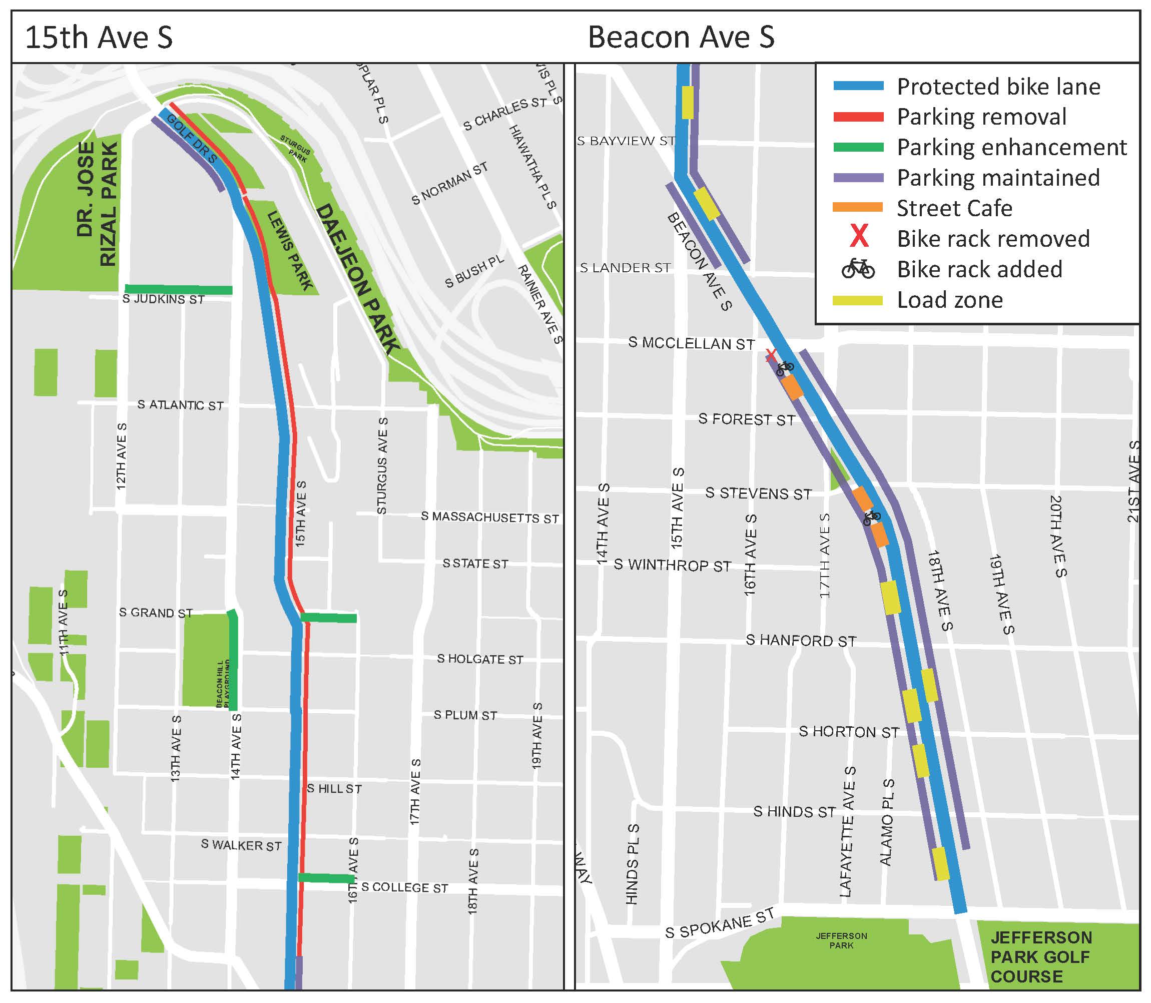
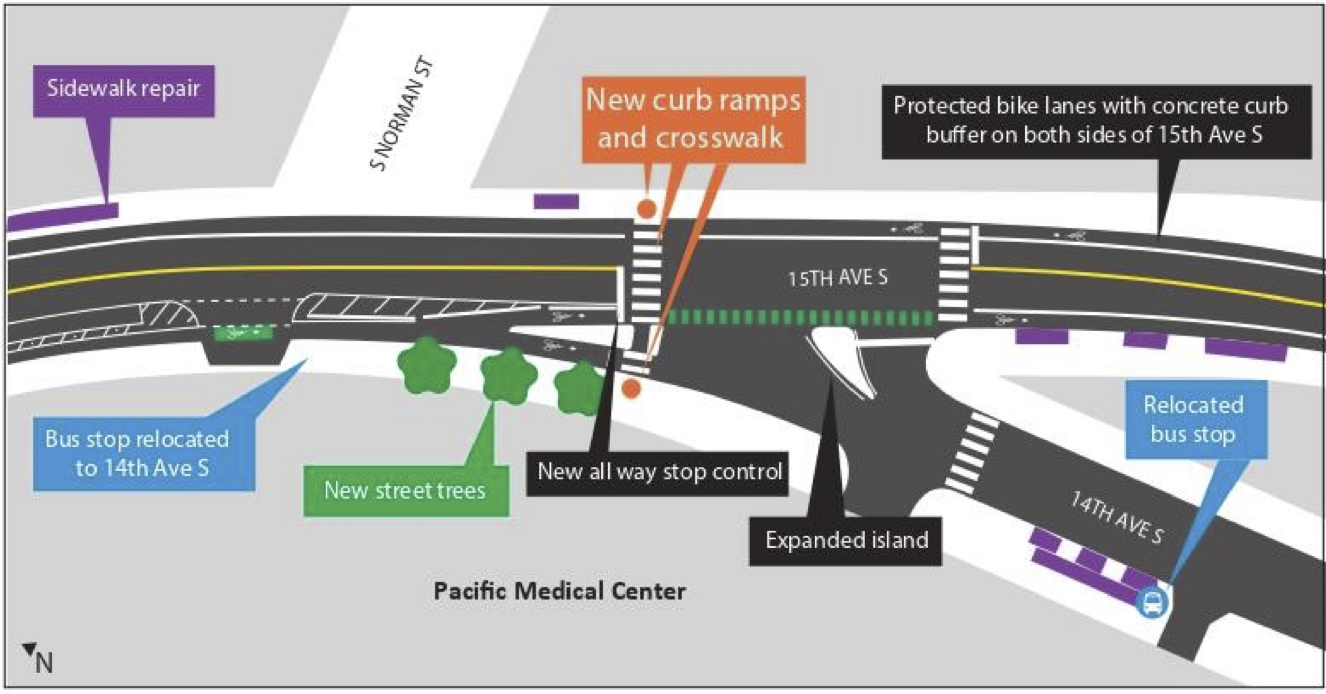
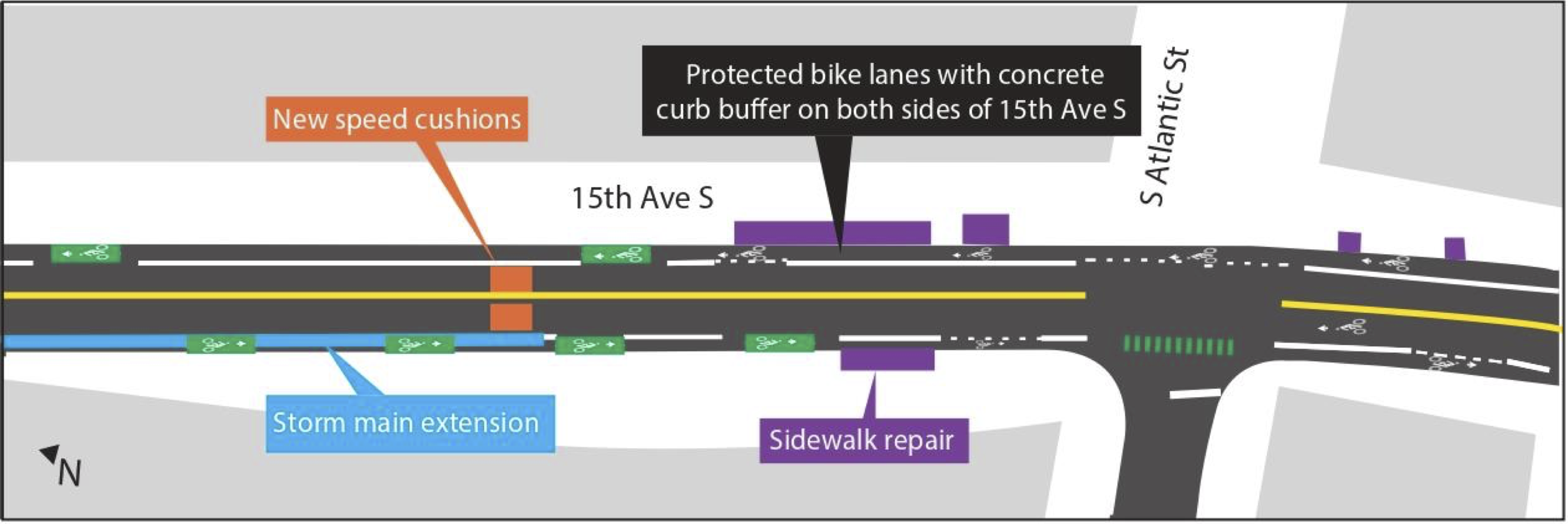
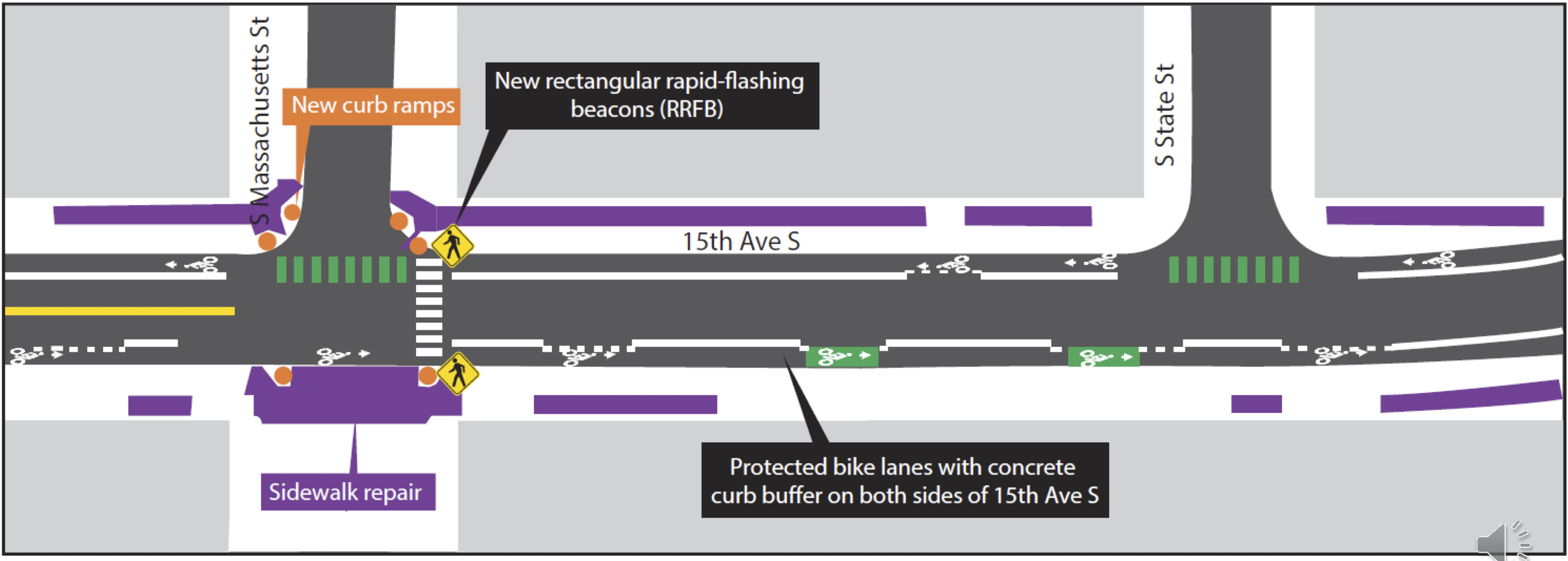
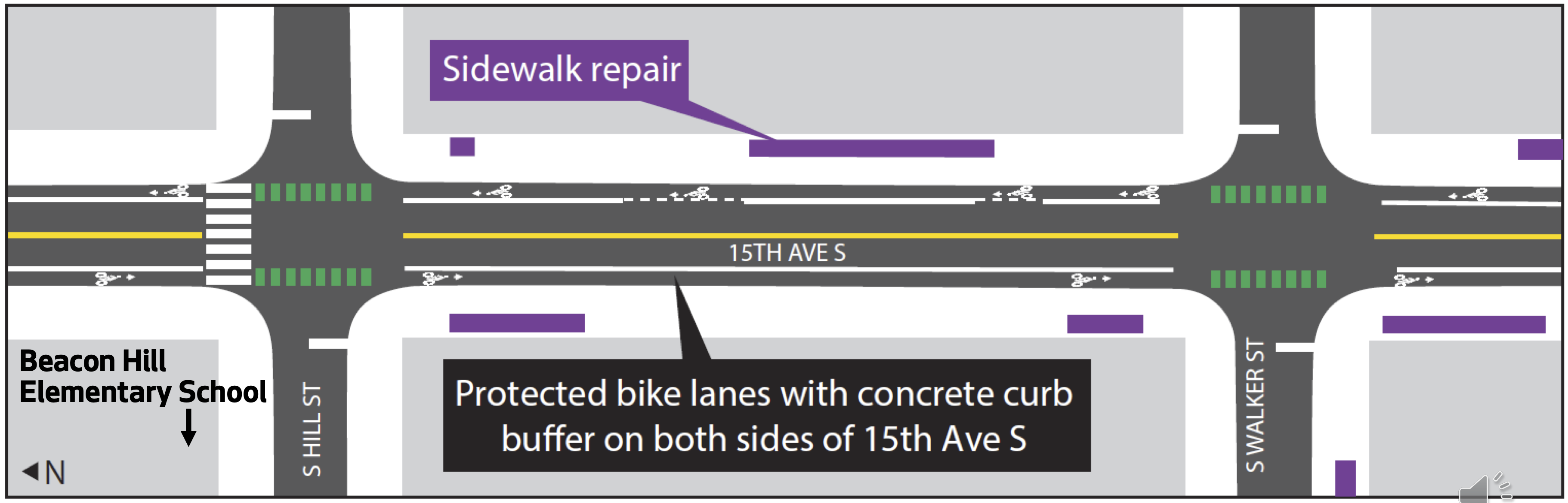
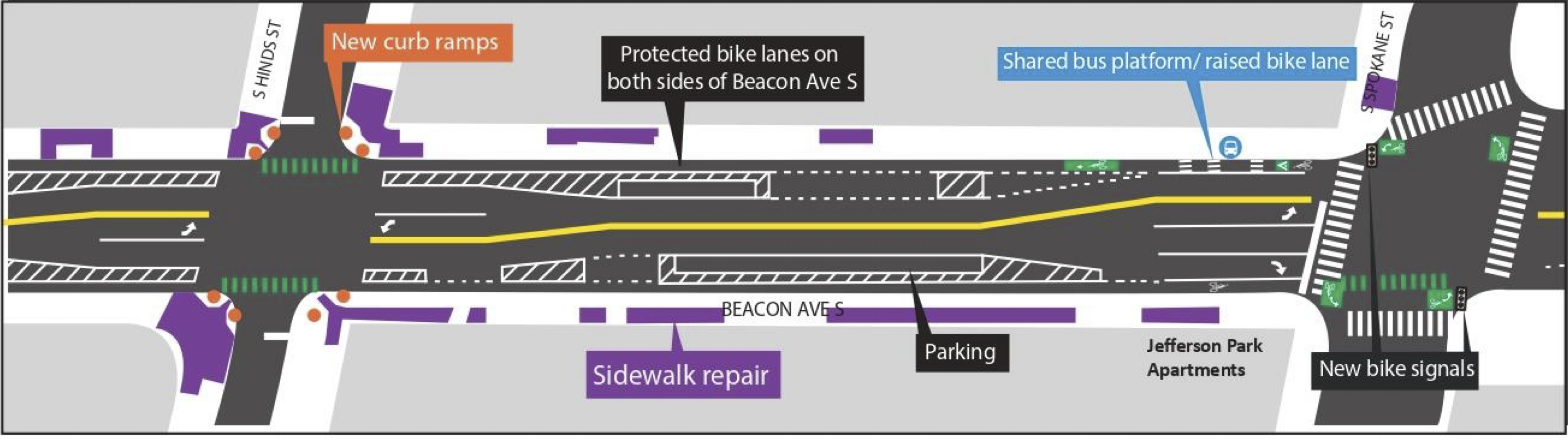
But even beyond biking, the planned design changes should bring significant safety improvements for everyone, including people crossing these 15th Ave S and Beacon Ave S on foot. The designs include 10-foot lanes for general traffic or 11-foot lanes for stretches where there are bus routes. Reducing lane widths calms traffic while also minimizing the time people using crosswalks are exposed to traffic. The design also includes curb bulbs and other crosswalk improvements.
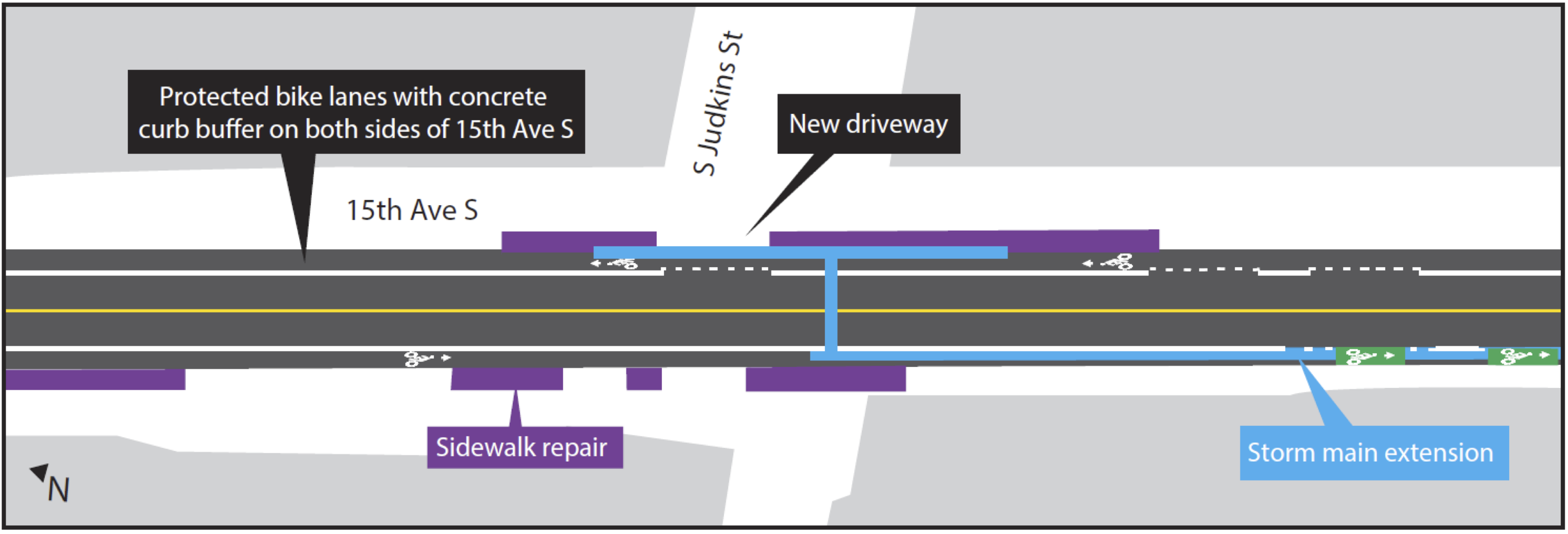
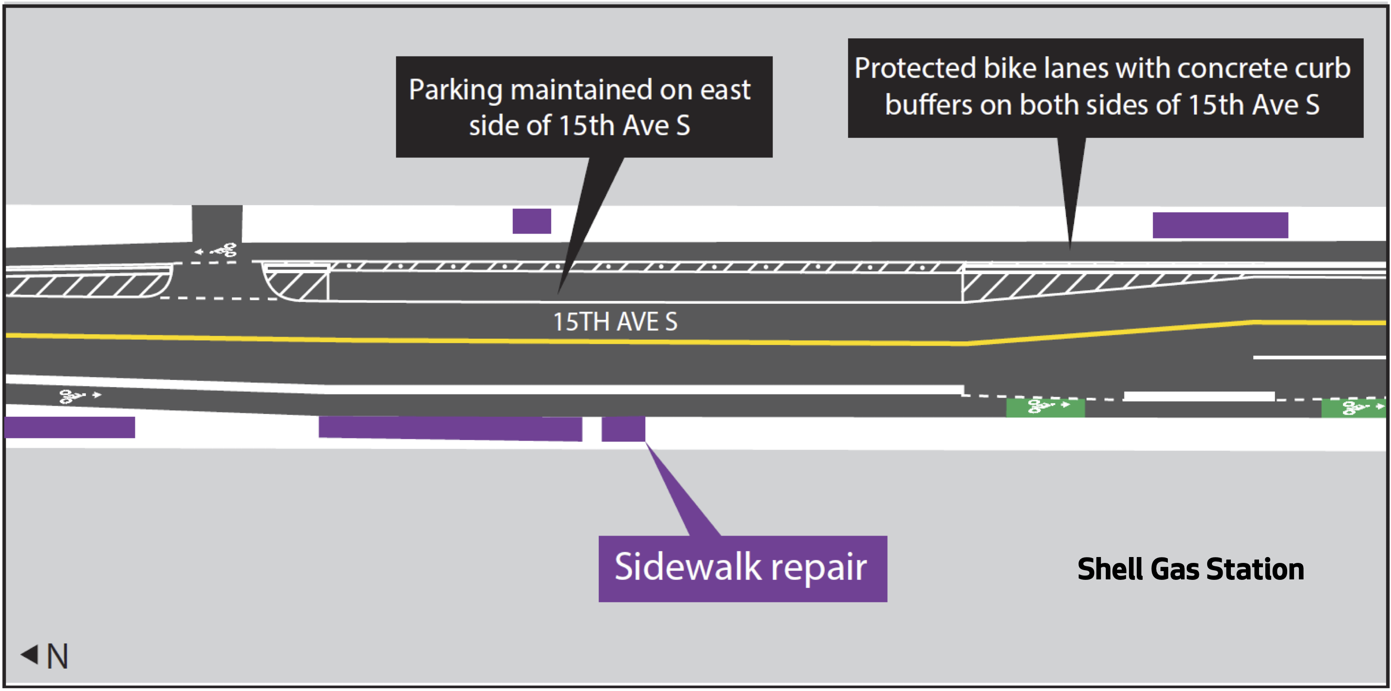
The 15th Ave S section will remove a lot of existing on-street parking, but staff scoured the area to find additional blocks that could be used for parking. They are also planning to remove a short and disconnected section of paint-only bike lane on 14th Ave S to turn that into on-street parking. We argued in a previous post that this is a worthwhile trade-off, though some readers pushed back and said they use it to access the school and the park and are concerned about safety during Beacon Hill Elementary School pick-up and drop-off. Hopefully this is something SDOT is paying close attention to.
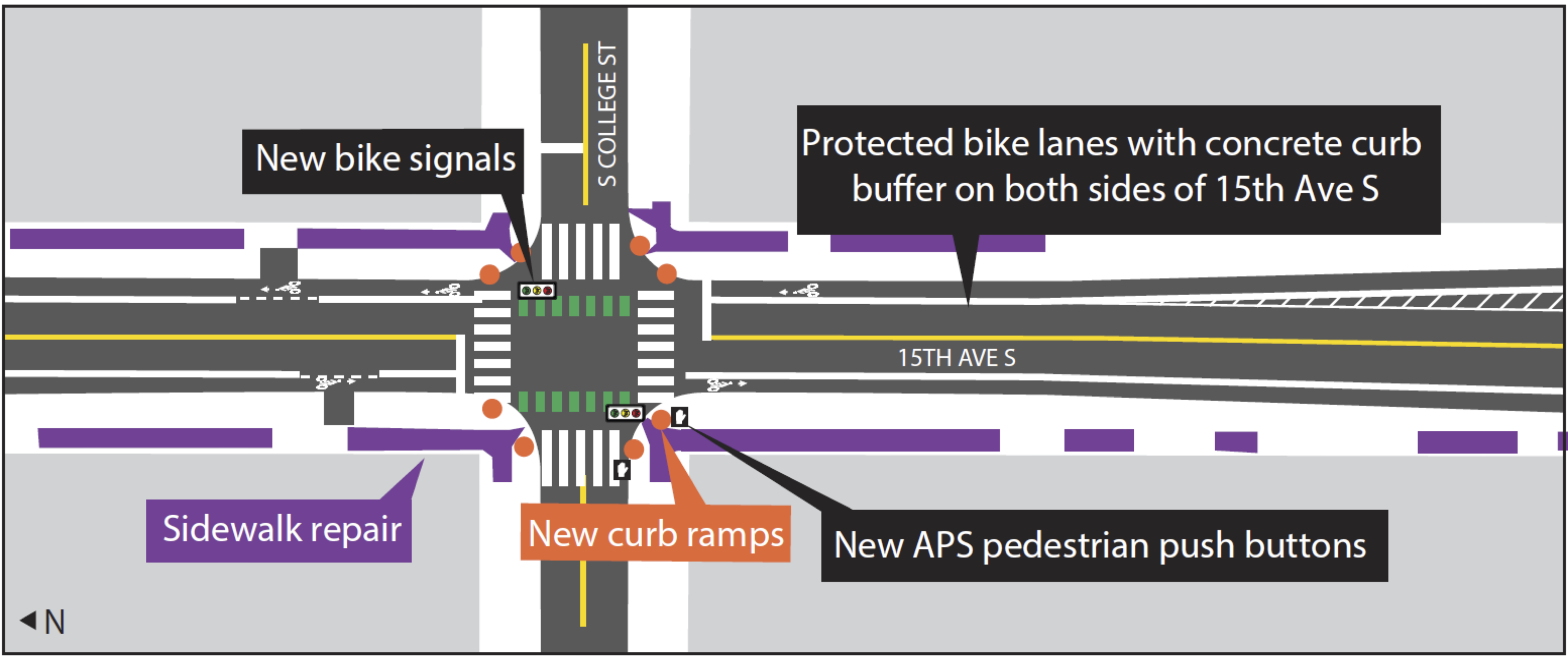
The most complicated part of the whole project is probably the intersection of 15th Ave S and Beacon Ave S. Not only is it at an angle, but it is also the busiest intersection. There is already a partial “scramble” walk phase in which all the crosswalks show “Walk” at the same time and no car movements are allowed, and this safety project will keep it. People biking will also be able to go straight or make any turning movements they need during this all-crosswalk phase, though they need to yield to people in crosswalks. People biking will also be able to go straight when the adjacent general traffic lights are green, though anyone trying to make a left turn after the all-crosswalk phase ends will need to use a left turn box as is common for many of the city’s bike lanes. The tricky part is communicating all this to people on bikes. The signal diagram in the plan appears to show the bike signal turning green whenever straight-traffic in the same direction is allowed as well as when the all-crosswalk phase is active. But how will someone biking know when it is too late in the all-crosswalk phase to start a left turn? Obviously, it would be bad for someone to start a long left turn at the same time that people in cars get their green lights. Also, does a green bike signal conflict with an all-crosswalk phase? A green bike signal tells people biking they have the right of way, so they would reasonably assume that any crosswalks in their path would be showing Don’t Walk. This is the first time Seattle has had to figure out how to add bike signals to this unique type of intersection. Does it require multiple sets of bike signals? Should the bike signal stay red during the all-crosswalk phase but be paired with a sign that says something like “🚲 May Use Ped Signal”? Or how about a flashing red or flashing yellow bike signal? Are those a thing? My kindergartner suggested rainbow lights that mean everyone should dance, which is at least worth considering. I asked SDOT staff during a recent press briefing how the signals will communicate when people biking can and cannot make left turns, and I will update when I hear back. Below is a technical plot from the 100% design showing the intersection and the signal phase diagram for anyone who wants to try to decipher it or come up with solutions:
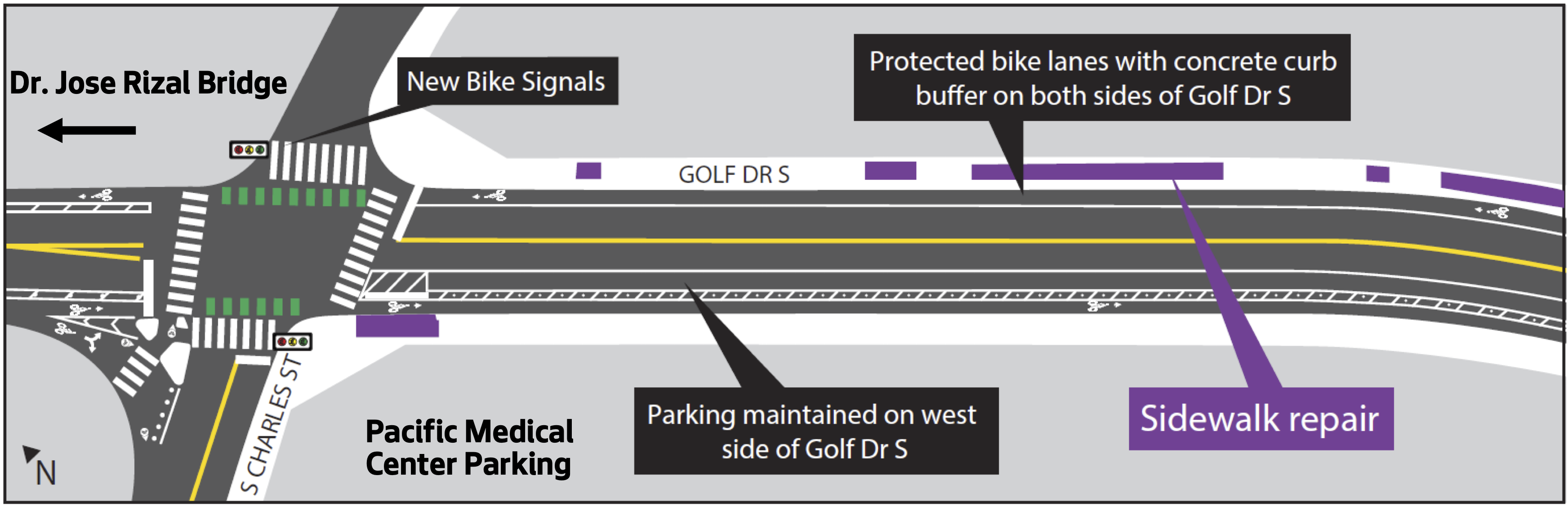
On the north end, the new bike lanes will connect directly with the José Rizal Bridge bike lanes installed in 2021 as well as the Mountains to Sound Trail. Which reminds me, it would be interesting to install a bike counter on the bridge before these new bike lanes open so we can gather some “before” data. Perhaps a nearby employer (someone in the Pacific Medical Center building perhaps?) would sponsor a counter with a display like on the Fremont and Spokane Street Bridges. The old slip lane island at S Charles Street could be a great spot to install a display. Or perhaps one could be hung on one of the trolley wire poles. We desperately need a good south end bike counter, and this bridge is probably the best southend bike route pinch point for getting a consistent measurement.
On the south end, the new bike lanes will end at S Spokane Street, which is a busier street that borders Jefferson Park. Future phases should extend the bike lanes south on Beacon Ave S, but they are not yet funded beyond very early planning. Adding these to the next transportation funding package and making sure they are earmarked for earlier in the funding timeline should be a priority because connectivity to South Beacon Hill and the S Columbian Way bike lanes will be a major gap in the bike network.
SDOT has made no major changes since the 90% design released a couple months ago. Below is an overview of the design concepts from a 90% design presentation (PDF). You can see the 100% design details in the less-user-friendly design plot (PDF):


Comments
15 responses to “SDOT completes design for North Beacon Hill bike lanes, construction should begin in summer”
Great writeup and great project. What is particularly notable is all of the sidewalk repairs noted on the plans…is that a result of Seattle’s new sidewalk repair ordinance? I’m used to these major corridor projects totally ignoring sidewalks, so it is a welcome sight.
https://council.seattle.gov/2023/12/12/seattle-city-council-passes-legislation-to-improve-sidewalks-across-the-city/
This much new good-quality bike lanes and more up-to-date street designs is nothing to sneeze at!
Whenever I go up to Beacon Hill I wonder what it was like there before I-5 and I-90 were built. The hill would always have been a bit of a barrier but… Seattle has a lot of steep hills without a freeway cordon around them that are more connected to their immediate surroundings!
Regarding the complication of bike movements during the pedestrian “scramble”…
– I wonder how obvious it is that the “scramble” is taking place when at any particular location you can’t see all the signals for every direction. It would be obvious for someone that’s familiar with the area. If I was unfamiliar with the intersection, wanted to make a left, and knew there was a turn box, I’d proceed to the turn box… then upon arriving, if I looked out and saw green, I’d go again in the new direction. That suggests keeping the bike signals green during the “scramble” makes sense… but I’m not the most important person to calibrate for (I’m unusually cautious and was making two-stage lefts on many Chicago streets before the first turn boxes were ever installed there). Something like green-with-flashing-yellow, or maybe yellow-and-green-both-flashing gets the vibe right? IDK. I feel pretty strongly that, if some riders would be seeing a green-bike just before the scramble, that they should get a caution and at least a brief red before the start of the scramble — we don’t want to have pedestrians start moving into the crosswalk while we’re sending bikes through at full-speed, that’s a recipe for crashes. Maybe some aggressive riders that know the scramble is coming would ignore the caution anyway…
– The scenario where you see a green bike signal and may not have the right-of-way is not quite unique to here. Along the 7th Ave PBL… I mean… I don’t know who’s supposed to have the right-of-way (IMO there’s a reasonable case either way), but it’s common for me to cross an intersection with a green-bike signal and have to wait for pedestrians that haven’t even looked up from their phones to realize they’re crossing a bike lane. Another place with similar pedestrian-bike conflict is the entrance to the Westlake Cycletrack from 9th Ave N. When you get the green-bike signal any pedestrians waiting to cross southbound will be standing directly in your way, waiting at a don’t-walk signal. Then the bike signal quickly turns red for the all-walk, though it’s perfectly safe for cyclists to go (and more polite for those pedestrians than going during our phase, since everyone’s moving and we can all easily go around each other without hopping the curb). It’s a little confusing… some riders that are apparently unfamiliar with the area don’t realize they can and should go during the all-walk, and some aggressive riders that are apparently familiar with the area aren’t cautious enough at the start of the all-walk… but it’s not anywhere close to the worst area for bike-ped conflicts I go through regularly.
This is great, I ride this stretch every day on my commute and it will be much safer after the improvements are installed. The most harrowing part of my commute, however, is through Jefferson Park just to the south of where this project ends. Drivers often use that stretch to get to or from the I-5 onramp, and often drive 40+ MPH in that 25 MPH zone. Hopefully SDOT tackles that next. Should be less complicated with the Seattle Parks property rather than the complicated stretch of Beacon and 15th Ave S.
Back in… maybe 2016 (?) when SDOT was doing Bike Master Plan planning they left the segment through Jefferson Park out of their (conceptual, non-committed) bike network in initial drafts… then put it back in in the final version. I remember commenting about what a hole this left in the network when I saw the initial draft, maybe enough other people made the same comment that they put it back in. The fact that they left it out initially suggests they might think it’s more complicated to do something near or on the parks property… the street itself is really narrow there so anything they do would have involve or affect the park in some way…
I’m so excited about this project! My girlfriend lived on Beacon Ave for years and I was constantly astounded at how hostile that street is to anyone outside of a car. Really looking forward to these improvements and can’t wait to ride down there once they open up!
I really like the idea of adding a bike counter on the bridge. Getting data is really important way to show how important protected safe lanes are now and in the future. I like it so much that I would be willing to put some money into a crowdsourced fund to make this happen.
We (I’m co-chair of Beacon Hill Safe Streets) are very excited for this segment of the project to get built! There are still the middle & south segments left to figure out (funding needs to be found) that will continue along the rest of the Beacon Ave corridor into South Beacon Hill, so we’ll continue to work on that.
Regarding the pedestrian scramble at 15th/Beacon: cyclists (including myself) already use the pedestrian scramble there to get through the intersection, and it’s assumed that pedestrians have right-of-way, so I don’t expect any changes in that situation.
Regarding the bike counter: there absolutely should be one on the Jose Rizal Bridge! Right now, the only bike counters in South Seattle are the I-90 Trail crossing Lake Washington, Spokane St Bridge, and Chief Sealth Trail, so people using the Jose Rizal Bridge to head into/out of South Seattle just don’t get counted. For reference, here’s the city’s list of bike counter locations: https://www.seattle.gov/transportation/projects-and-programs/programs/bike-program/bike-counters
And the Chief Sealth trail counter is out of order.
Yeah, that one is in a bad place (south of the busier and better-connected sections of the trail) and is really unreliable. That’s why I don’t write about it much. The data has lots of gaps.
Thinking about combination of pedestrian scramble in combination with green for cyclists: intersection of 15th Ave NE and NE 40st has this also (cyclists are supposed to use the pedestrian lights there.) This is on the edge of UW Campus. And yes pedestrians have right of way. Not sure if that is officially the case but that is how it works.
The shape of the 15th & Beacon intersection reminds me of the one at 46th & Green Lake, which SDOT recently “improved” as part of their route 44 project. Unfortunately their design choices weren’t great, to the point that over half the time we used the east crosswalk we would have near-misses with drivers who were either confused or intentionally blowing the red light because they would either be thinking they were turning left, or actually turning left and wanting to go straight (the new signal phase has a left turn where traffic goes straight from 46th towards the crosswalk for a bit before turning onto Green Lake, while straight-through traffic is stopped).
I would hope SDOT has learned from their mistakes but so far we’ve had very little success getting SDOT to come back and actually fix the intersection, so something to be aware of if SDOT tries to make similar changes.
The sad thing is that for the handful of bikers, a lot of low-income/handicap/tax paying property owners/renters along 15th avenue will have nowhere to park; 90% of these folks depend on a car to get to work efficiently to make a living.
The argument for bike lanes is that people need it to commute, but isn’t that what the lightrail and buses are for? During outreach, it was determined that the majority of bikers going through 15th & 14th avenue were not even living in these neighborhoods, but didn’t want bike lanes in their own neighborhoods. Majority of bikers using these corridors were also doing it recreationally and only 2-3 days a week NOT for work.
The city received federal funding which requires bike lanes to be added throughout the city, and so low income neighborhoods are now unfortunately the victim of predatory infrastructure design.
Many other major cities have been sued post completion of their “bike lane” projects, and have had to reverse designs of their streets. In others words, wasted tax money. Seattle will be facing the same thing once citizens here become enraged by the unfair and predatory city planning. It just takes a class action suit and signatures from sufficient number of property owners and residents in the area.
This is the issue with how city of seattle operates – pushes poor agendas through only to reverse on them later and costing tax payers more money and headaches than was needed.
Also, the number of bikers on these corridors are significantly low throughout the day – those of us who live here have set up 24/7 cameras to see how many people actually bike through in a day.
Counts of cars parked on the street were taken during the peak of Covid when people moved out of the city – and taken during work hours when people weren’t home, instead of in the evening. Most residents here are blue collar and don’t get to work remotely. No recount was done now that Covid is over and population has increased in the city post Covid.
The city won’t release the true numbers as it doesn’t support their decision to go through with bike lanes to gain federal funds.
Your comments have a lot of strange, non-factual or vague claims in them, but I want to push back specifically against one — “the number of bikers on these corridors are significantly low throughout the day”. Gosh… it’s almost like if an area is terrible and unsafe to ride your bike through, you’re not going to ride through there. I wonder what would happen if you improved the route and made it safer?
You also seem to be completely ignoring the fact that this is a safety project, not a “bike lanes project.” You reference poor neighbors. How expensive do you think it is to get around the city on a bike vs a car? Or to walk or bike to a bus stop or light rail and use public transit, vs. a car?
Imagine a day when your neighbors, young and old, can ride a bike / e-bike to the ID for dim sum or banh mi or shopping at Uwajimaya, ride a bike to the Beacon Hill library or light rail station or Red Apple supermarket, all without fearing for their life in high speed traffic.
You seemed concerned with disabled neighbors. Imagine a day when your neighbors using walkers or in a wheelchair using 15th Ave S. can navigate more easily on repaired sidewalks and new ADA compliant curbs, and cross the street more safely on new and improved crosswalks.
Well, you won’t have to imagine much longer, because this project is bringing all that.
Not sure where you’re getting your information here, but there’s a lot wrong here. First off, plenty of “low-income/handicap/tax paying property owners/renters along 15th avenue” ride bikes. You are trying to frame it as though people biking are some “others,” but they’re not. Many of them are your neighbors. Some are from outside Beacon Hill, of course, because that’s how roads work. But also, people from Columbia City or wherever else are also your neighbors. And literally nobody is saying the city should build bike lanes in Beacon Hill because they don’t want them in their neighborhood. In fact, the south end and beacon hill have been neglected when it comes to safe bike routes, a historical problem the city is finally working to address by projects like this one. Finally, no federal funds went into this project as you say. It was funded using proceeds from the Mercer Megablock property sale as well as property taxes from the Move Seattle Levy, which people who bike also pay.