
Neighborhood greenways have a hit and miss history in Seattle. Sometimes they create fantastic all ages and abilities walking and biking connections, and sometimes they are so heavily compromised that they do very little. So as Seattle prepares to create a new transportation plan and craft a new transportation funding measure, we should probably get a handle on what works, what doesn’t and why.
Ryan Packer at the Urbanist posed the issue in a recent post:
Seattle’s greenway network turns 12 years old this year, with the 39th Avenue NE greenway in Wedgwood one of the very first corridors that the Seattle Department of Transportation (SDOT) upgraded when it tried out the idea in mid-2012, right after N 43rd and N 44th Streets in Wallingford. At the time, Seattle was following in the footsteps of Portland, Oregon, which officially started branding its bike boulevards “neighborhood greenways” in 2009, but which had been implementing projects like them going back to the 1980s.
— Advertisement —
As Seattle starts to consider the next iteration of the 2015 Move Seattle levy, which expires at the end of the year, the city has an opportunity to reassess how neighborhood greenway infrastructure has been implemented, and how big of a role the continued expansion of the network should have moving forward. With significant gaps still remaining in the on-street bike network, and many miles of bike lanes still in need of upgrades in the form of physical protection and signal infrastructure, 2024 could be a key decision point.
Read more…
Most (or perhaps all) of the worst neighborhood greenways in Seattle have one thing in common: They were created not to build new connections for people but rather as a way for SDOT to avoid building bike lanes and better crosswalks on a nearby arterial street. Many of the city’s worst neighborhood greenways were started for the wrong reasons and had project-breaking limitations baked into them from day one.
A great (or terrible?) example is the stretch of neighborhood greenway on 17th Ave SW in Delridge. Picture this: You’re biking along, following the helpful signs pointing the way along the neighborhood greenway when all of sudden there is a staircase in the middle of the road.
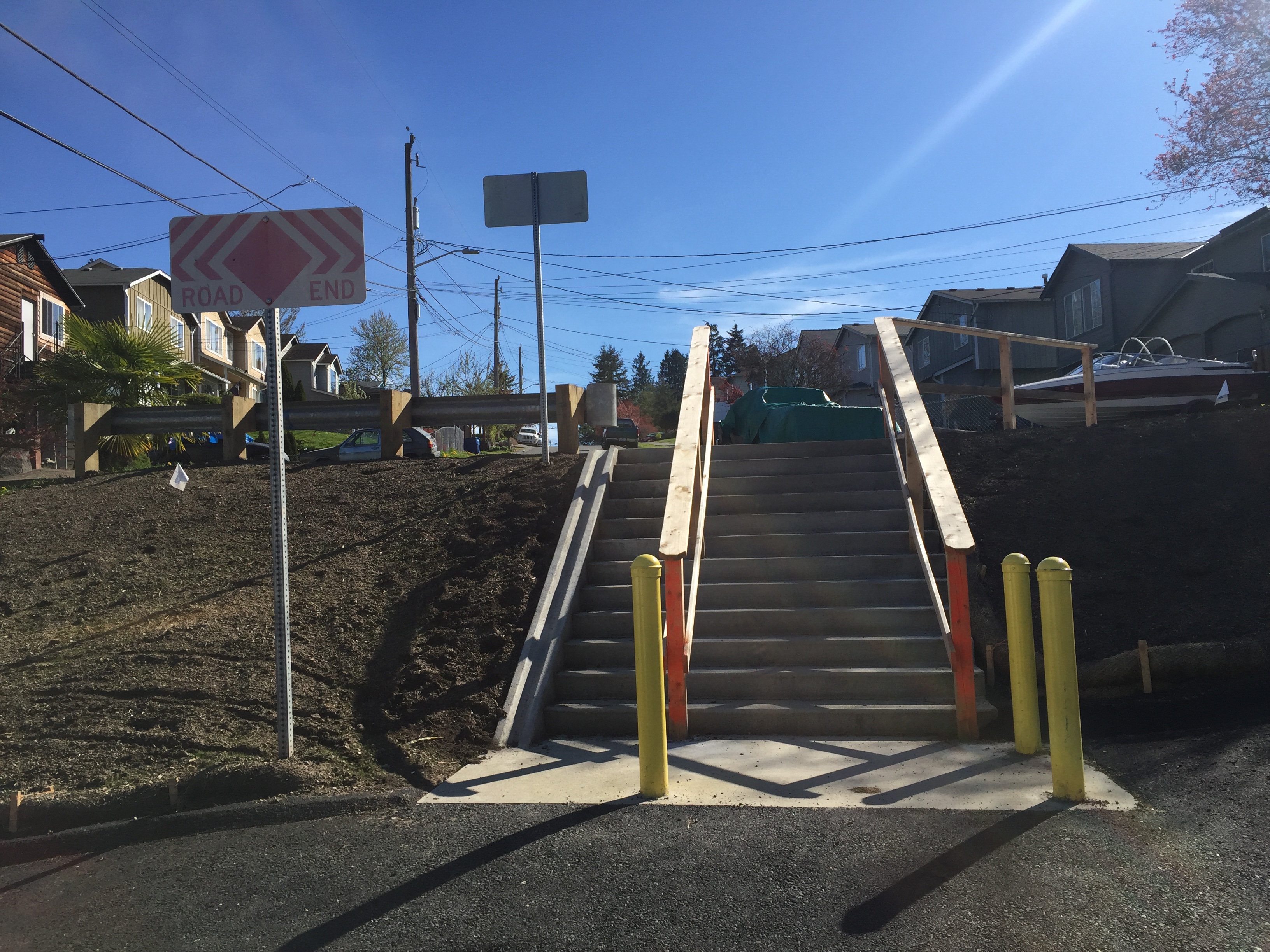
You have to get off your bike, then try to maneuver the tires into a “runnel” so you can push it up 12 steps before you can continue on. Then a block later, the route turns and crosses 16th Ave SW at a traffic signal only to travel two blocks on 15th Ave SW before crossing 16th Ave SW again at another traffic signal before turning back onto 17th Ave SW. If you follow the greenway route, it genuinely feels insulting when you cross the street the second time within sight of the place where you just crossed a minute ago.
It feels like the city is messing with you. Why would they waste your time like this? Rather than creating a comfortable and welcoming experience, traveling this section of neighborhood greenway feels like the city is telling you to get out of the way of the people it values more: People driving (and parking) cars.
Perhaps an more well-known example, however, is the Rainier Valley Neighborhood Greenway. There are parts of the route, especially near Columbia City, where the greenway route makes some absurd climbs and turns in order to avoid using the only obvious option for traveling north and south through the business district: Rainier Ave.
But other parts of the Rainier Valley Greenway are great examples of how a neighborhood greenway can be an effective tool for creating new connections. When the route is trying to be its own thing, it’s kind of great, but when it tries to replace Rainier Ave it is terrible. It’s a great route for getting from Sam Smith Park and the I-90 bike tunnel to Franklin High School and John Muir Elementary School, for example. I also like the way it connects into Genesee Park. There is no single arterial street that makes these connections the way the neighborhood greenway does. I also love the way it connects into the paths through the playfield near Dunlap Elementary and South Shore K-8. It feels like you’ve found a secret. The route takes you almost through people’s home gardens in a really lovely way. When the greenway is allowed to be itself, it’s a great addition to the neighborhood. But it is not and never will be a replacement for bike lanes on MLK and/or Rainier Ave.
Another example of a great neighborhood greenway, look at the Beacon Hill Neighborhood Greenway, which connects the Mountains to Sound Trail at 18th Ave S to Beacon Hill Station, Jefferson Park and then to Georgetown via the Lucile Street bridge. There is no arterial street that makes this connection. Instead, the greenway route invented a new connection based on organizing from within the neighborhood. I still think it is one of the best neighborhood greenways in the city.
One common problem on many of the city’s neighborhood greenways, including some sections of the Rainier Valley route, is SDOT’s reluctance to install actual traffic diverters (also known as traffic “filters” since they allow biking and walking but not driving). Diverters are the elements most likely to face pushback from neighbors who don’t want to drive around the block or people who like to use the street as a cut-through, but without them the streets often feel too dangerous to meet their all ages and abilities goals. A greenway should be considered a failure or incomplete if a child cannot comfortably bike there. Ideally, the only people driving on a neighborhood greenway are people accessing a destination on that street. Once you have people driving there who are just trying to get somewhere else (possibly because Google Maps told them to do it), you lose the comfortable pace and welcoming feeling that makes these routes work. Diverters should be placed at regular intervals along these routes. And they need to be concrete and permanent, not just a sign that people can either run over or ignore.
We also need to more effectively work Seattle Parks into the neighborhood greenway plans. So far, SDOT has mostly avoided routing greenways through parks, but parks are often the highlights of a bike route. Parks also form a kind of traffic diverter, making routes that travel through them that much more pleasant. Obviously not every park or path is appropriate for a designated bike route, but we need SDOT and Parks to both want to identify and activate the opportunities we do have. As it is, we rarely see effective collaboration between the two departments around the goal of building bike routes, and that’s a shame.
Neighborhood greenways can be great, but they need to be built for the right reasons and with the top priority of creating a space that is safe and comfortable for people of all ages and abilities to walk and bike. The city should figure out a way to codify these goals and standards in city policy and in the next transportation funding measure.


Comments
10 responses to “Seattle’s mixed history building neighborhood greenways”
Sometimes the greenways that are there to substitute for arterials work well, too. The Ballard ones (58th and 17th) are pretty good and they’re essentially substitutes for Market and 15th. Both substitute-Delridge greenways could be really good if we took them seriously enough to make them work as well as the Ballard ones do. 26th should be a great route, since it doesn’t need a steep climb to/from the bridge, and includes back-roads connections to Camp Long and the High Point neighborhood… and the work needed at the southern end to make it connect through (e.g. to Chief Sealth Intl. HS, which comes to mind for me because I rode this way to get my first COVID vaccine shot) doesn’t seem all that hard if anyone really cares.
If we try to run greenways through parks more often we need to do better with lighting. Our existing bike network relies a lot on parks because it relies a lot on off-street paths (more than other cities I’ve lived in, for sure!). The idea that some parks are all-day, all-year routes for biking and walking is met by the parks departments with either indifference or hostility, which is to me is one of the most consistent difficulties with biking through the winter here. An existing greenway connection that uses a park is NW 92nd, which goes through Crown Hill Park near the Holman Way overpass. This greenway has other problems west of there (there’s not even an attmept to make an ALEGRA-ish connection for the last couple blocks to 17th) but specifically in the park the lack of lighting makes it harder to follow route markings and to see others using the path. And that segment is popular enough that I do encounter other people on it after dark every now and then!
I totally agree about the lack of traffic filters. When the city first started working on designing the greenways, I was excited because I had seen how well the “bike boulevards” in Portland work. A big part of that success in Portland was due to regular use of traffic filters. But then I was dismayed when I didn’t see any filters in the designs or implementation of greenways in Seattle. I’ve made countless comments to SDOT about this, but it never seems to make a difference. It’s a shame. Greenways would be so much safer and comfortable if they were included.
Thank you so much for this, Tom. I completely agree and am so tired of our city prioritizing cars over pedestrians, cyclists, and people in wheelchairs. Our city is so dangerous and hard to navigate when you’re not in a car. We know what solutions would improve our street safety and sidewalks – we just need money and political will invested in those solutions.
I wonder if it’s possible to have such a thing as a virtual traffic filter. Meaning that Google Maps and other software would be required by law to treat it as if it were a real filter, but there would be no physical barrier or even signage on the street. The virtual traffic filter location would instead be published to a data feed, which the tech companies would be required to honor, or else get fined by the city. But enforcement would be strictly limited to tech companies, not drivers, and, as a driver, driving through would still remain legal.
A virtual traffic filter could also exempt door to door delivery vehicles in order to avoid awkward movement of big trucks trying to turn around on narrow streets.
The idea being that if 80% of drivers are slaves to their phones, a virtual traffic filter can eliminate 80% of through traffic at the cost of nothing more than a few buttons on a computer screen.
I’m not sure if a virtual traffic filter is something a city is even allowed to do under the law, but if so, it would have some interesting implications for greenways.
Interesting idea!
I think about this a lot. Some cities in New Jersey have flirted with similar ideas. Here’s an example: https://www.nj.com/hudson/2021/10/jersey-city-closes-downtown-road-during-morning-rush-to-halt-holland-tunnel-cut-through-traffic.html
I can’t find the story right now, but I remember reading about another city also in Jersey I believe that was “closing” streets but not actually putting up signs or barriers. They were just trying to get people to stop exiting the freeway to take their local streets after Waze/Google started telling them to do it.
In a way, our Healthy Streets are sort of doing this now. Those streets are “closed,” but they really aren’t. Sure, there’s a physical presence to them so they aren’t only digital, but appearing as a closed street SHOULD change the way routing apps work. Unfortunately, I just tested it on 1st Ave NW around N 85th Street, and Google happily offered a driving route down 1st, which has “STREET CLOSED” signs at the start of nearly every block. So perhaps step one is for the city to try to get map companies to include these already legally-closed streets.
There could be some unintended consequences or complications of giving putting the government in charge of maintaining a digital road map all mapping companies must follow that we are not considering.
I just realized this is a good story idea. I’ve added it to my list.
Disclosure: I used to work on Google Maps data. I left a few years ago, back before COVID hit. As far as I know I’m not spilling any non-public info; if I did it would likely be outdated. My opinions, as anyone I worked with at the time can attest, are my own.
OpenStreetMap has public documentation about its schema and policies. Google has similar documentation that’s private, and I have to imagine Apple and Uber and all the others do, too. The schemas and policies are all going to be a little different, and in all cases they may not perfectly describe how the data actually looks (documentation is often incomplete, aspirational, outdated, etc.). That’s the kind of stuff I mean when I talk about schemas and policies.
OK.
I wouldn’t put much hope in getting map data providers to put invisible digital fences around roads. They’re usually resistant to that sort of thing — their goal is to serve their users convenient and legal directions, not to solve a city’s problems. If the city puts its money where its mouth is and creates clear, followable rules about street usage, marked by standard, legal signs, it’ll go it. Advisory signs that aren’t actual rules probably won’t make the cut. Actual rules with conditions or exceptions that are hard to apply by software, or that aren’t considered by the schema, might not make the cut (but if they’re in widespread use and they make a difference for routing they might update the schema and/or routing software to account for them). But if it’s just, “We’d like it if people didn’t go through here,” well, the people most likely to do this are squeaky-wheel NIMBYs trying to foist traffic on other towns. The next-most-likely people would be anti-cycling types that want bikes off their roads. This is stuff cities usually don’t have the authority to do, and… that’s mostly good. The public roads are public. When cities and towns send their police forces to try to identify and harass out-of-town drivers (it has happened in America!) we generally consider that an abuse. I don’t have much more sympathy for nudging them out via GPS.
I sometimes think the mappers are too rigid on that point, and they should be able to discourage through-travel on particularly ill-suited streets without needing specific signage, or discourage turns that are legal but dangerous — that can serve users’ safety and comfort. But mostly it’s going to be up to cities to make rules.
When it comes to the Stay Healthy Streets with their sorta-fake “Street Closed” signs… I don’t actually know what any private mapper’s policy says about those. OSMWiki mentions Seattle because of course it does, we take up a lot of space online. If mappers and routers take these signs as intended, considering such streets like woonerfs or bike boulevards by policy, that might result in car through-traffic being strongly discouraged on them, but probably quite as strictly as a block-specific local-traffic-only requirement.
If you can generate car directions in Google Maps that use these streets as through-streets in direct contradiction of actual signage maybe report a problem with the directions. For best results maybe describe how the directions are directly contradicted by the closure signage, and that the closure doesn’t apply to bikes and pedestrians? If your report is read by a person (if it makes it through all the filters and queues) that person will be a busy worker going through a whole pile of reports, not a long-winded bike nerd like me. You probably won’t get much of a response but it might result in a change… the change might even be correct!
Effectively doing stuff in the OpenStreetMap world is a whole different process that’s more communitarian and, annoyingly, can result in mapping practices and standards that aren’t very consistent. But that’s not likely to affect much driver behavior.
I think this is a great idea. Over the last few years, I’ve noticed increasing amounts of cut-through traffic on Woodland Park in Wallingford between 46th and Bridge Way. Because of the width of the street, many of these drivers feel entitled to go 40+ mph. I’m almost positive many of them are just following some phone app that says it’s 5 seconds faster than Stone Way. I’ve suggested to SDOT that they consider narrowing the street, or at least putting all-way stops in to make Stone Way more appealing, but maybe the purely technical solution would be more viable. It’s ridiculous that the western terminus of the Wallingford greenway has basically turned into a highway because of the lack of attention from SDOT.
Another item in the “what doesn’t work” category in my experience is dealing with head-on traffic on narrow streets with both sides parking. There are certain greenway blocks I’ve given up on riding entirely (21st b/w Denny and John) because I find it so frustrating to have to engage in what feels like a complex negotiation with every vehicle travelling in the opposite direction. I find it especially difficult when I ride with my child and have to constantly give instructions on whether to keep riding strait or duck behind some parked car to get out of the way.
I know narrow streets slow traffic but there’s something about sharing ~12ft with two way traffic that just doesn’t work in my experience even at low traffic volumes.