
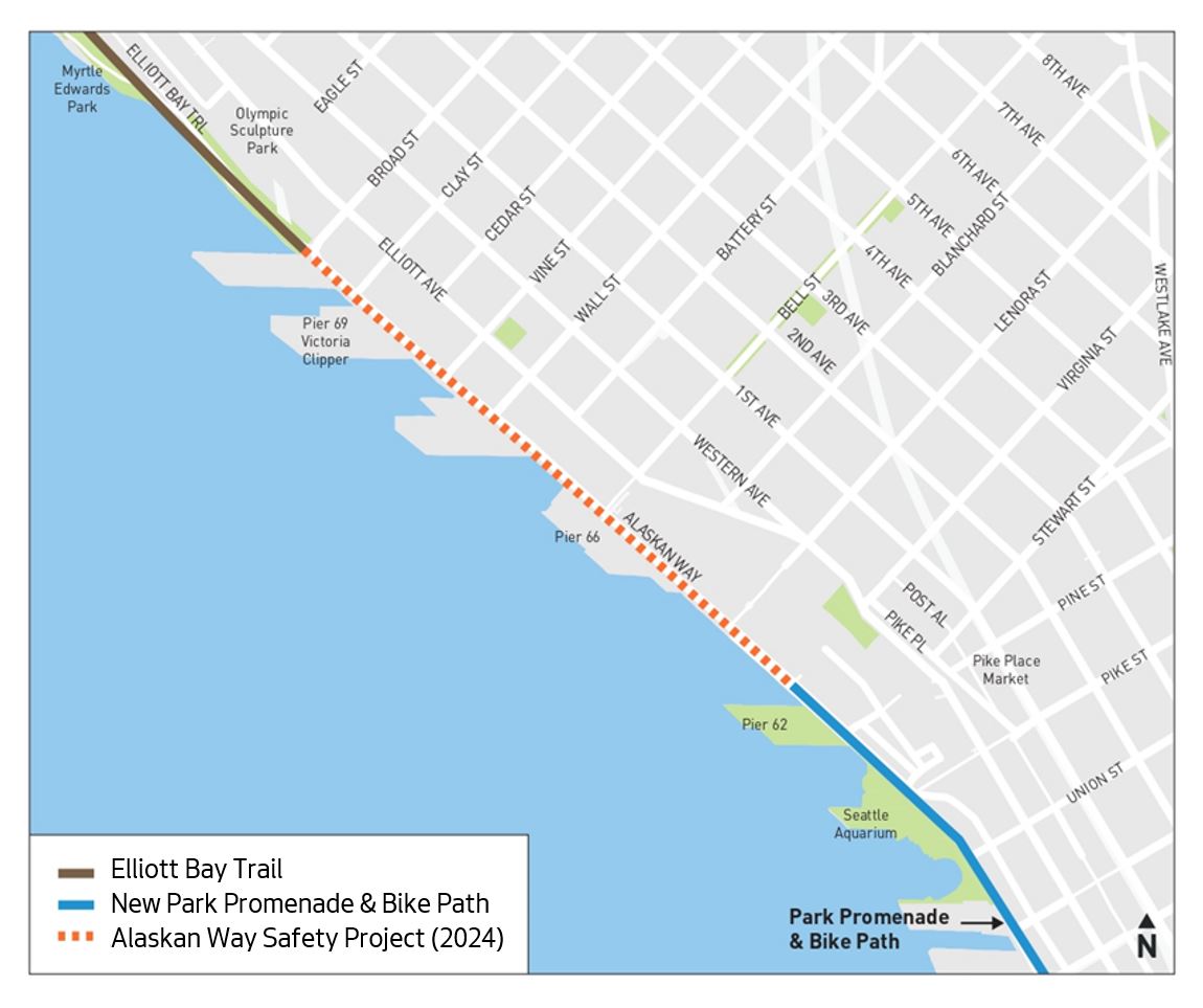
The design for the Alaskan Way bike lane has reached the 90% milestone, and the latest version is wider and better protected. As before, the bike lane is still on the waterfront side of the street to connect the Elliott Bay Trail in Myrtle Edwards Park to the in-construction bikeway that is part of the Alaskan Way Viaduct Replacement Project. But the city responded to feedback from Cascade Bicycle Club, Seattle Neighborhood Greenways and many of you, and the new design by widening much of the path to 12 feet and protecting the removable section with removable bollards.
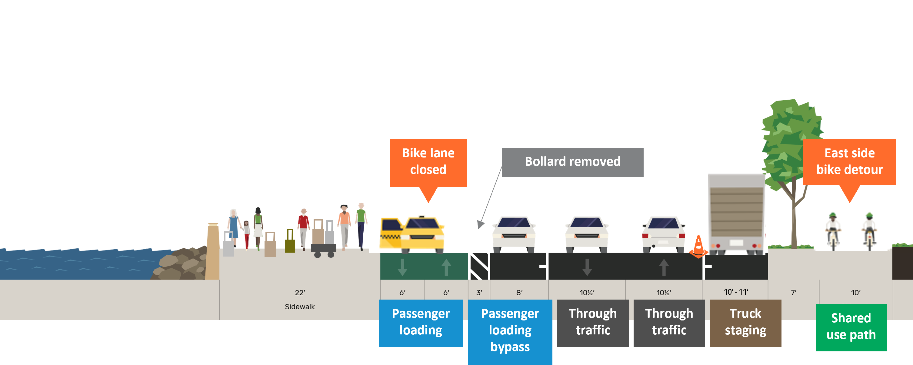
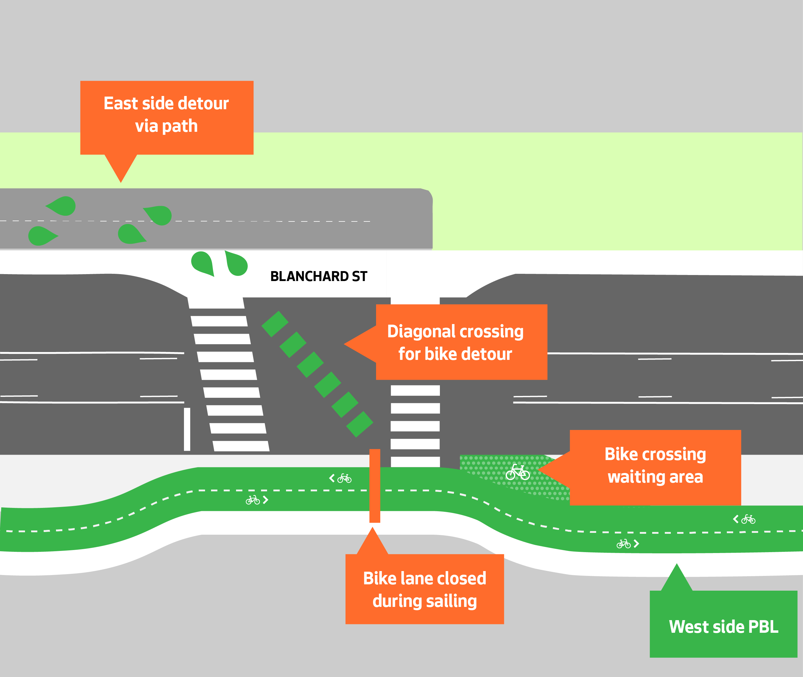
Oh yes, if you are new to this project, you’re probably wondering what I mean by a “removable section.” This whole project was in jeopardy not so long ago due to concerns by the Port of Seattle that it would interfere with cruise ship loading and unloading at Pier 66. So the compromise is that the cruise terminal can detour the bike path to a path on the other side of the street during sailing days, then remove the bollards and allow loading in the bike lane space. During peak season, there are often 5 sailing days per week with far fewer during the off-season. Loading hours are often busiest between 6 a.m. and 4 p.m., so there is also potential to work commute hours into the bike lane closure plan. Those details are still being worked out. It’s a novel solution, and it will be interesting to see how it works out in practice. (UPDATED this paragraph to add sailing schedule info from a project Q&A and video presentation).
Here’s how SDOT describes the latest design changes:
Changes since 60% design:
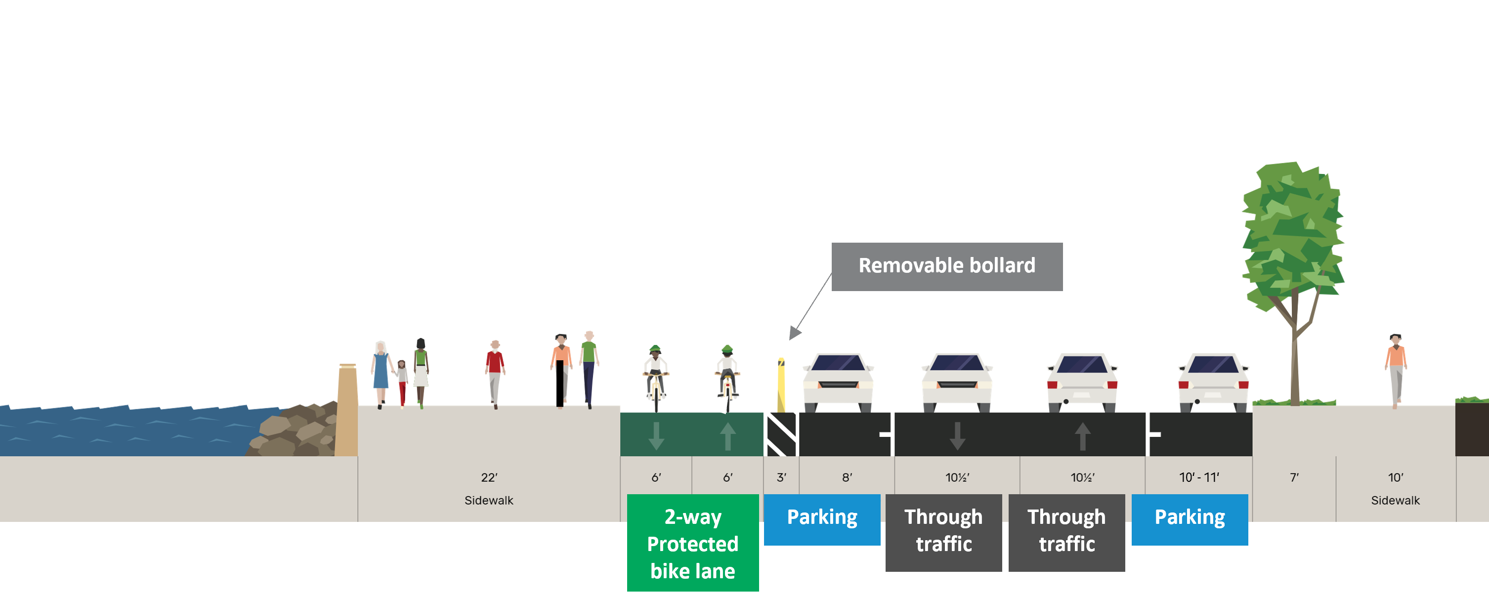
- Street-level protected bike lane in front of Pier 66 (west side of Alaskan Way from Blanchard St to Wall St) on non-sailing days
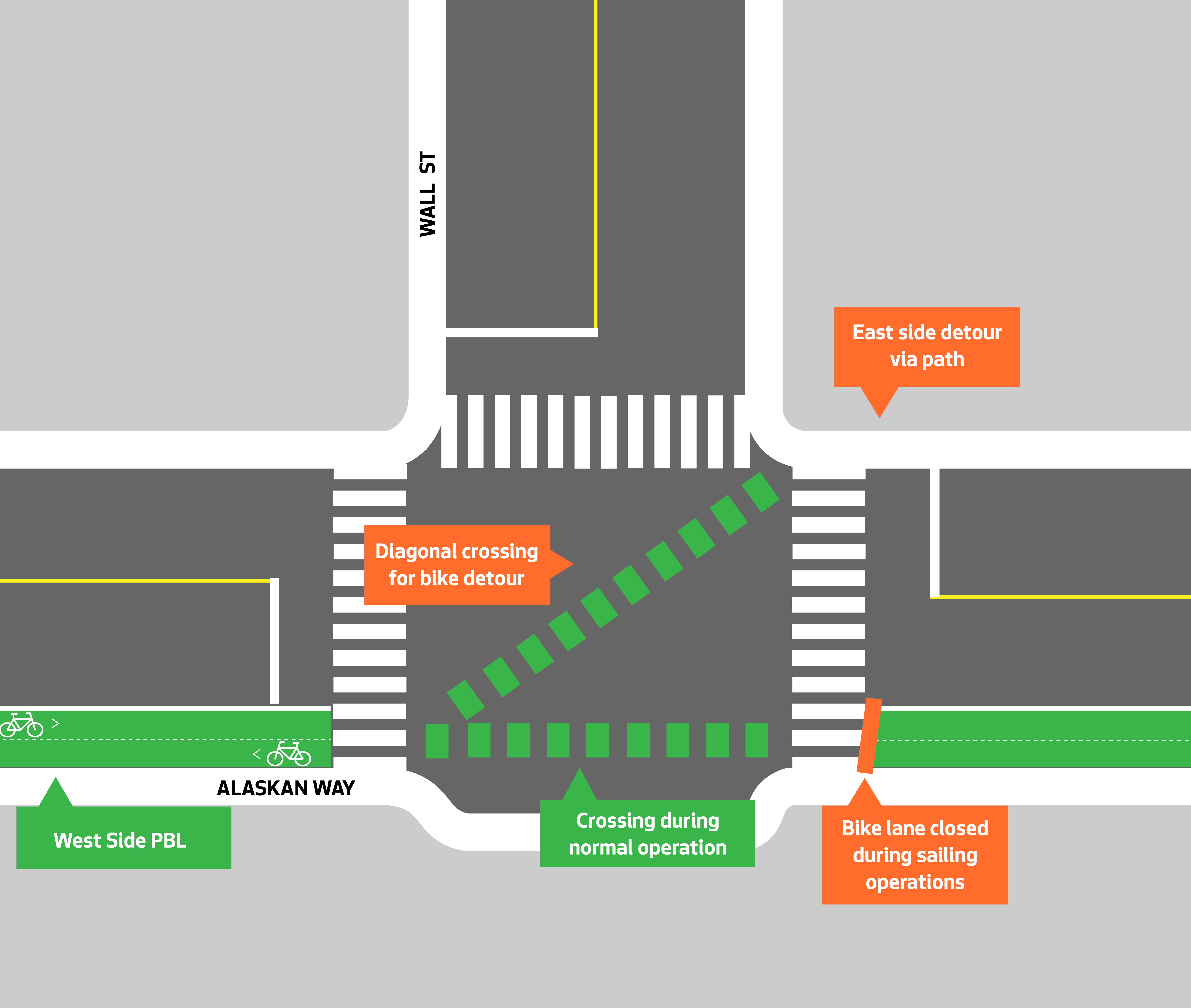
- Upgraded traffic signal at Blanchard St (to full traffic signal for all directions at this intersection)
- Widened segments of west side protected bike lanes from 10 feet to 12 feet
- Updated plans for removable bollards in front of Pier 66
And though it is not part of this project, the privately-funded trail extension on the east side of the street should make the detour experience better.
Below is the updated design for when the bike lane is in place near Pier 66:
And here it is when the bike lane is detoured:
They have also updated the crossing points at the beginning and end of the detour, including a full traffic signal at Blanchard Street:
SDOT says the design should be finalized in early 2024 and construction should begin later next year.
Seattle Neighborhood Greenways has created a handy online tool you can use to thank SDOT and the Mayor’s Office for the latest changes. Below is their sample letter text:
Dear Seattle Department of Transportation and Mayor’s Office,
Thank you for designing a solution to close the gap between the waterfront trail (which ends at the Seattle Aquarium), and the Elliot Bay Trail (which ends at the Sculpture Park) with a 12′ protected trail on the water-side of the street!
This will be an iconic and important trail connection used by thousands of people every day thanks to the robust design that provides real protection and sufficient width to make it comfortable for people using pedicabs, adaptive cycles, cargo bikes, and family bikes which tend to be wider than standard bikes.
Thank you
Also, I just want to keep putting the idea out there that this is a great opportunity to rename the mishmash of different waterfront biking and walking paths into one cohesive placemaking name. Once all these sections are complete and connected we could even celebrate with a naming ceremony or something, though the E Marginal Way project is still years from completion and should probably be part of the new name. The “Elliott Bay Trail” seemed to be the favorite option last time I asked this question. Or we could name the section from Spokane Street to Smith Cove the “Waterfront Trail,” which is already how people refer to it casually. The Interbay section of the Elliott Bay Trail should probably become something like the “Interbay Trail,” especially if we use the name Elliott Bay Trail to describe the part along the bay.


Comments
5 responses to “Alaskan Way bikeway will be wider, better protected in latest design update – UPDATED”
I’m happy to see a compromise. I think this will work reasonably well, though I will probably just ride in the traffic lane. But for those who don’t want to ride in traffic, I’m delighted to see this solution.
I was hoping for a somewhat better solution where the main traffic lanes would be pushed to the east and the bike lane could remain on the west side. With the extra space afforded by pushing the traffic lanes to the east, a permanent load-unload area could have been located between the sidewalk and the bike lanes. This solution still may have required traffic lights for bikes and traffic intersecting the load-unload area but at least bikes wouldn’t have to cross the street.
Tom, it looks like the graphic for the Cruise time crossing at Blanchard has been updated on the SDOT website. They are currently showing it with a 45 degree diagonal green bicycle crossing instead of the 90 degree crossing. Makes more sense now. The 90 degree direction change seemed a bit harsh.
Thanks! I updated the post.
This is great news. Very glad SDOT listened to feedback and realized that a few cruise days per year does not warrant a year-round bike detour. The solution looks simple and pragmatic.
Now, what needs to be done to the SDOT culture to get them to propose options like this from the get go, rather than having to be pushed?
I think there will be a lot of cyclists riding past the bollards at the cruise ship terminal along this busy corridor.