
Developing plans to create new walking and mountain bike trails in the overgrown Cheasty Greenspace between Rainier Vista and Beacon Hill has run into a problem: The proposed plan may not include enough trails to meet the project’s goals.
That’s the essence of a recent letter (PDF) from the largely advisory Board of Parks Commissioners to members of the City Council and the Mayor asking for more guidance on the scope of the controversial pilot project approved over the summer. The pilot is designed to see whether building trails for walking and mountain biking through undeveloped green spaces could be a sustainable way to increase access to natural spaces, defend urban forests from destructive invasive species, provide safe routes to school and improve public safety.
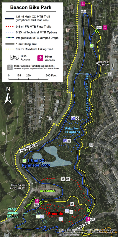
That’s a lot of goals to accomplish with just a few trails, but the extremely active and engaged supporters and volunteers powering the project are determined to make it happen, including Eagle Scout candidate Chiem “Oou” Saeteurn as shown in this video:
However, there are people who do not like the project, mostly citing environmental concerns.
“If human activity increases within Cheasty Greenspace, it is likely that the wildlife will suffer,” according to the petition. As of press time, 464 people has signed this request to only build walking trails.
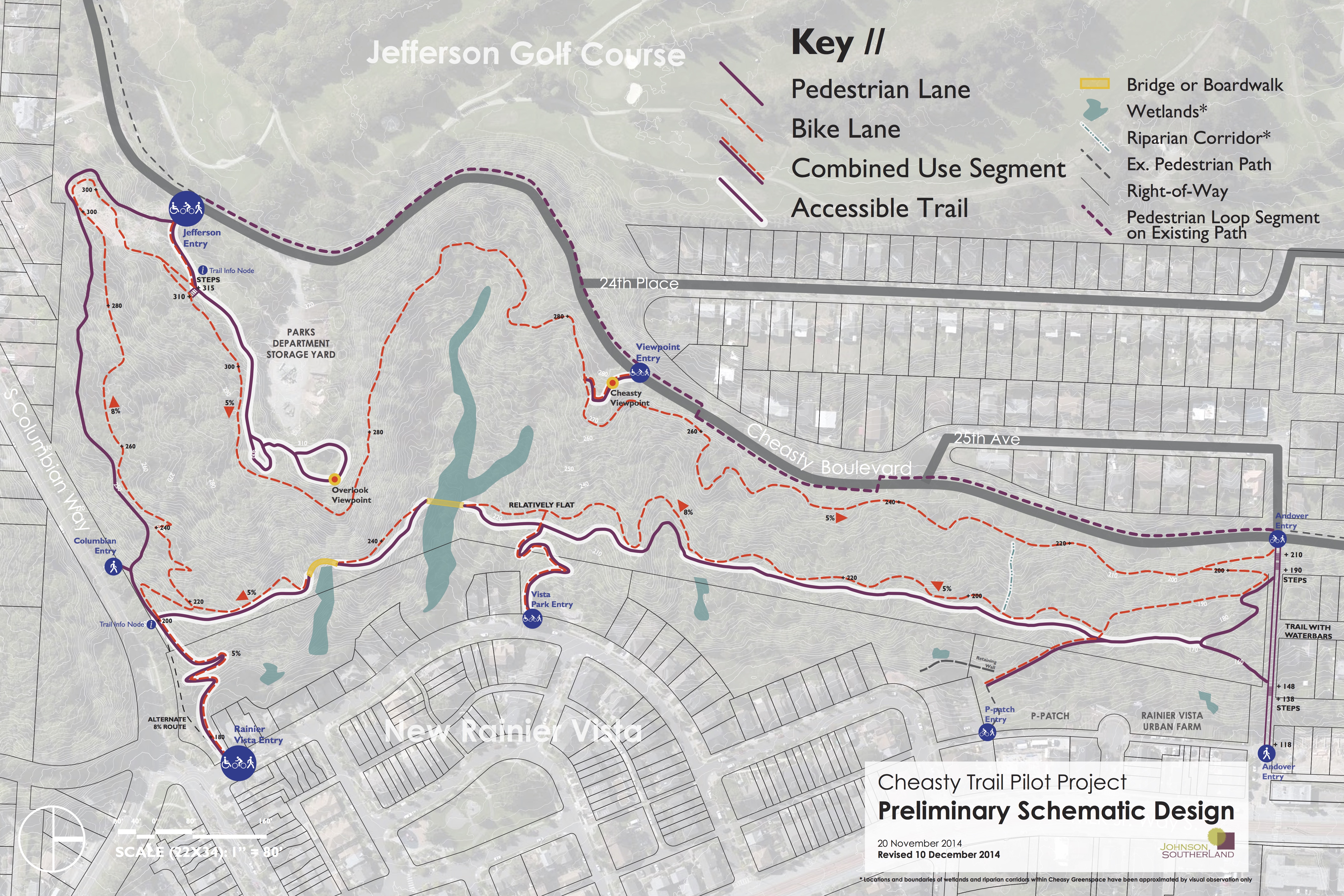
But the Parks Board sees the opposite problem. Where the original plan included biking and walking trails around the perimeter of Cheasty and through parts of the center, plans were scaled back to just include the perimeter trails (pictured at the top of this post) as something of a compromise.
However, the Parks Board is concerned that some of the project’s major goals would not be met by just a perimeter trail. Here’s how the Board outlined their concerns (see their full memo (PDF) for more background):
- Constrained Access: By only building the perimeter trail, significant user groups are effectively denied the opportunity to use the space, notably the students and parents living in Rainier Vista and served by Kimball Elementary. From both a Race and Social Justice and Safe Routes to School perspective, we have concerns about this lack of access. Additionally, parents with young kids of several kids may find a long perimeter trail unmanageable as they try to provide effective supervision.
- Endangered Sustainable Stewardship: The one aspect of the plan that everyone agrees on is the importance of forest restoration. Our hope was that by having the bike park partners be the implementers and stewards of the forest, the plants would thrive at the same time that the bike park took root. In fact, the volunteers in Cheasty recorded the second most GSP volunteer hours of any restoration area last year. By only developing the perimeter trail, current plans may hinder this goal. Best practices for mountain bike trail-building—tested and developed over several decades in forests around the world—recommend using fall line loops to provide riders of various skills with appropriate challenges so that they do not build their own trails. Without planning for and accommodating these users, we fear that desire lines will be created through the forest, potentially damaging newly planted natives.
- Safety: Safety becomes an issue on two fronts when the conversation is limited to the perimeter trail. First, the long distance and relative isolation of segments of the perimeter trail may present some challenges from a crime prevention through environmental design (CPTED) perspective. Second, without thoughtful professional planning for fall line trails, ad hoc trails may create unsafe junctions with the perimeter trail.
If you are interested in getting involved, the fourth of five Project Advisory Team meetings is 6 p.m. tonight (Thursday) at Jefferson Park Community Center.


Comments
12 responses to “Parks Board wants more MTB and walking trails in Cheasty”
So are they scaling back the project’s trails to placate the hand wringers with the petition? Or is it due to some kind of funding issue?
Promoting mountain biking in this area is a fantastic idea! It promotes exercise and gets people (especially youth) into their parks and away from video games and displays. The idea that this is some treasured wilderness that must be protected is completely without merit. It’s urban greenspace, not endangered habitat.
It is really encouraging to see such strong community support.
I couldn’t agree with you more, SGG. It’s true that mountain bikes tear up parks and people shouldn’t be riding them between the trees in the arboretum, for example.. But if the park can be designed to keep bikes on the trails, this is an excellent use of urban space.
Mountain bike tracks are suitable for active recreation areas, and it would be great if the Parks Department found suitable locations for a few of them in the city. But Cheasty Greenspace is what the Parks Department calls a natural area, and some of the neighbors don’t want it converted into an active recreation park, which the mountain bikers would effectively do.
Seattle has very few natural areas, and it’s not correct to view them as just empty space awaiting conversion to regular active parks. Nobody, neither the mountain bike advocates nor the Parks Department, did any kind of alternatives analysis. No effort was given to finding better locations for the mountain bikers.
The conflict has pitted mountain bikers against natural areas, and that’s too bad. The city needs both.
@RDPence –
MTB trails are suited to many types of areas, including natural areas. In fact, most urban MTB trails in the country are in areas that are classified by the parent city as “natural”, hence the desire to put the trails there. This may come as shock to a lot of people, but MTBers kinda like riding bikes in the woods, hence the desire to put the trails where trees grow. From the Duluth Traverse (nearing 100 miles in length) in the Duluth city forest to trails of the Knoxville Urban Wilderness, MTB trails and forested/wilderness lands co-exist and thrive in many cities.
Not sure how a MTB converts a park or area to “active recreation”. If you mean in clearing the ground for trails, MTB trails are actually very narrow and revegetate quite quickly. See: https://www.flickr.com/photos/bikeportland/15752084294 That is quite different than clearing areas for a basketball court or something.
You are correct on one thing: both the Parks Department & FoCMV made mistakes. The Parks Department in not calling up places that have had urban MTB for the last 15yrs to learn how to do it right, the FoCMV for proposing trails that have no place in an urban trail system (freeride/downhill). When you do urban MTB trails, the approach is much different than MTB trails in park or the countryside.
There are plenty of areas that are as natural, or more natural than this that have lots of trails through them. Discover Park is a great example. It has huge amounts of late successional forest as well as plenty of trails. Meanwhile, Schmitz and Seward Park both contain old growth forest, which this area does not (and both contain plenty of trails). Properly managed, trails and forest go together really well.
There is a legitimate concern with a mountain bike trail. Generally speaking, they can easily tear up the ground very fast (much faster than a pedestrian trail can) but this is where the experts come in. They know how to make a trail, whether for feet or tires. Erosion control isn’t simple; a well managed bike trail will cause a lot less damage than an impromptu pedestrian trail (e. g. Mailbox Peak). Furthermore, this area recovers very quickly. This isn’t like the mountains, where a few dozen people stomping around will lead to old plants being crushed (and scars that will last a decade). This is the wet northwest, where the biggest concern (by far) is slides. Again, this is why the folks who know what their doing need to design the trails. It also makes sense to monitor the area for slides and close it during heavy rains if there is a concern. But I see no reason why this can’t be managed the same way that the east or west side of Queen Anne greenbelt is managed (except in this case with mountain bikes). Those areas are heavily forested, very steep, but you can’t even see the trails.
The City Council made very clear recommendations and limitations to Parks about this pilot. It gave clear directions about Cheasty to Parks. I suggest Parks communicate directly with the Council, rather than use an advisory group to further their agenda.
The Cheasty PAT is very divided and dysfunctional. The Community meeting is happening right now. There is MUCH more to the opposition to the bike park than a petition and the 3 sentences it is given in this post.
Looks like it’s a lot of Himalayan Blackberries to me. I suspect the opposition has less to do with maintaining some ecosystem, and more to do with nimby issues such as increased demand for limited parking and such.
I really don’t understand the hostility to mountain biking here in this state. You go to Oregon, Northern California, and BC, and they really embrace it, integrating it into their parks just fine. Those locations all have the same soil and weather conditions we do. for whatever reason, it’s just in our DNA to oppose stuff like this.
Another city park that should allow mountain bikes is Discovery Park. There are a lot of very wide, very open gravel paths there that are completely suitable for riding your bike, but a one-size-fits-all ban prevents anyone from riding on these.
I saw the below posted earlier today and it makes sense to me!
Myth: City Council ordinance #124546 blocks the PAT from analyzing and recommending cross trails.
Facy: The City Council ordinance states that “(DPR) shall complete a full public process and technical review of the proposed design for the multi-use bike and pedestrian perimeter trail, including review of engineering, environmental, design, and community factors, make necessary revisions to the proposed design, and report to the City Council’s Parks, Seattle Center, Libraries and Gender Pay Equity (PSCLGPE) Committee.” This is a minimum requirement for the Neighborhood Matching Fund grant to be released to build the outer-loop trail system. There is no language in the ordinance prohibiting consideration of cross-slope trails. What the ordinance does require is that a complete and full public process, including technical review, be made and reported to City Council before the committee and then full council will evaluate the proposal and release the funds. To have that ordinance be interpreted as the maximum recommendation that DPR and the PAT can give to City Council, would imply that the City Council has the authority to take a grant written to purchase apples and say that it can only be used to purchase a single durian. That is fundamentally not how the grant process works or should work: with a grant you either grant what was proposed, make suggestions on how to modify the proposal and obtain agreement on those changes and then grant the money, or do not issue the grant. It is not appropriate to use a grant to restrict the scope of a project and City Council is aware that it is inappropriate, which is why its ordinance is a minimum requirement and not an absolute maximum.
When City Council passed the ordinance funding the Cheasty trails, on Aug.11, their discussion made it crystal clear they were supporting only a single multi-use perimeter trail around Cheasty Greenspace, and that cross trails were not to be considered. That’s the legislative history. I admire your creative interpretation, trying to morph council’s action into something greater than what they said.
At the Jan. 21 PAT meeting, their technical experts said that trails should run parallel to the topography (level trails). They recommended against cross trails because they would run against the topography and increase erosion.
A pedestrian path along Andover is far steeper than a path from Cheasty Viewpoint to Vista Park, so obviously they were able to ignore there concerns with parts of the proposal. That included stairs, but I don’t think that would be necessary for the other ridge (since it is a ridge that is not very steep). A few switchbacks at most, and it would be just fine (I’ve hiked on a lot steeper trails that don’t have erosion problems). But even if it required stairs, those are part of the other proposals anyway, so it shouldn’t eliminate would arguably be the most important part of the new trails (a pedestrian route connecting neighborhoods).
The area area the Overlook Viewpoint, on the hand, does have legitimate concerns over erosion (that area is very steep, and gullies could easily be formed). The best bet in that area would be go down the hill by cutting back sharply south. That isn’t that different than the original proposal, and should really be the plan for now. Run three or four bike paths heading west from that part of the bike route, and ignore the rest for now. The other routes are in areas that are much steeper. It is hard to describe what I’m proposing, but start at the Jefferson Entry, then head towards the steps, then follow the bike path as it heads towards the Overlook Viewpoint (or just below). Right about where the 5% arrow is, I would add bike paths heading left (or south). There are opportunities there for a fair number, really. It is not as crazy steep there, and there are few ridges, so you could add several without much concern about erosion.
From a pedestrian standpoint, the current plan is a huge disappointment. Right now, to get from Beacon Hill to Rainier Vista (or Rainier Valley in general) is a long, ugly walk (http://goo.gl/maps/qS8fa). The addition of these trails makes it a little better, but it is still requires a long detour. The parks department is right to be concerned. Urban parks often serve as routes through a neighborhood, as well as destinations. If I want to get from Roosevelt to the U-District, I’ll walk through Ravenna, via the 20th street (pedestrian only) bridge. If I want to get from Wallingford to Phinney Ridge, I’ll cut through Woodland Park (and over the Aurora overpasses).
With the addition of a few routes, this could provide something that is missing in the area — a pleasant, fairly direct route from one neighborhood to the other. At a minimum, I would connect Cheasty Viewpoint with Vista Park entry (see the first map). The grade here is minimal, compared to the rest of the area (zoom in and you can see the topo lines). There is a fairly consistent, fairly gradual ridge. This is the ideal place to put a trail (from an erosion standpoint). From the Viewpoint Entry (at the top of this trail) you could walk to 24th Place, and then get to Kimball Elementary via a set of quiet, safe streets.
On the other hand, it is very steep from the Overlook Viewpoint down to the valley. But the city has built a lot of very steep paths — they just built them with stairs. Nearby Andover (part of this proposal) contains dozens of stairs, in an area just as steep. That is a lot more work, so I would make that a secondary priority.
But I really see no reason why they can’t build a path from the Viewpoint Entry (via Cheasty Viewpoint) to the Vista Park Entry. That would be a very stable trail and provide a very pleasant, very efficient pedestrian path to connect neighborhoods. At a minimum, this trail should be added to the plan.
The proposed perimeter walking path (see map able) provides convenient access between Rainier Vista and Cheasty Blvd. There is no need for east-west cross paths — which mountain bikers would quickly convert into bike tracks.
Re the City Council mandate of Aug. 11, councilmembers made clear their opposition to cross-paths. And the geotech consultant identified them as an erosion hazard.