
Mayor Bruce Harrell’s proposed Seattle Transportation Plan (“STP”) is now in the hands of the City Council, who can make some final changes before adopting it as official city policy. The STP will supersede the 2014 Bicycle Master Plan, so it’s important to take a close look at its vision for the next 10–20 years of bike improvements across the city. To do so, Seattle Bike Blog will post a series of six stories focusing on different areas of the city. You find other areas as well as other STP-related stories through the 2024 Seattle Transportation Plan tag.
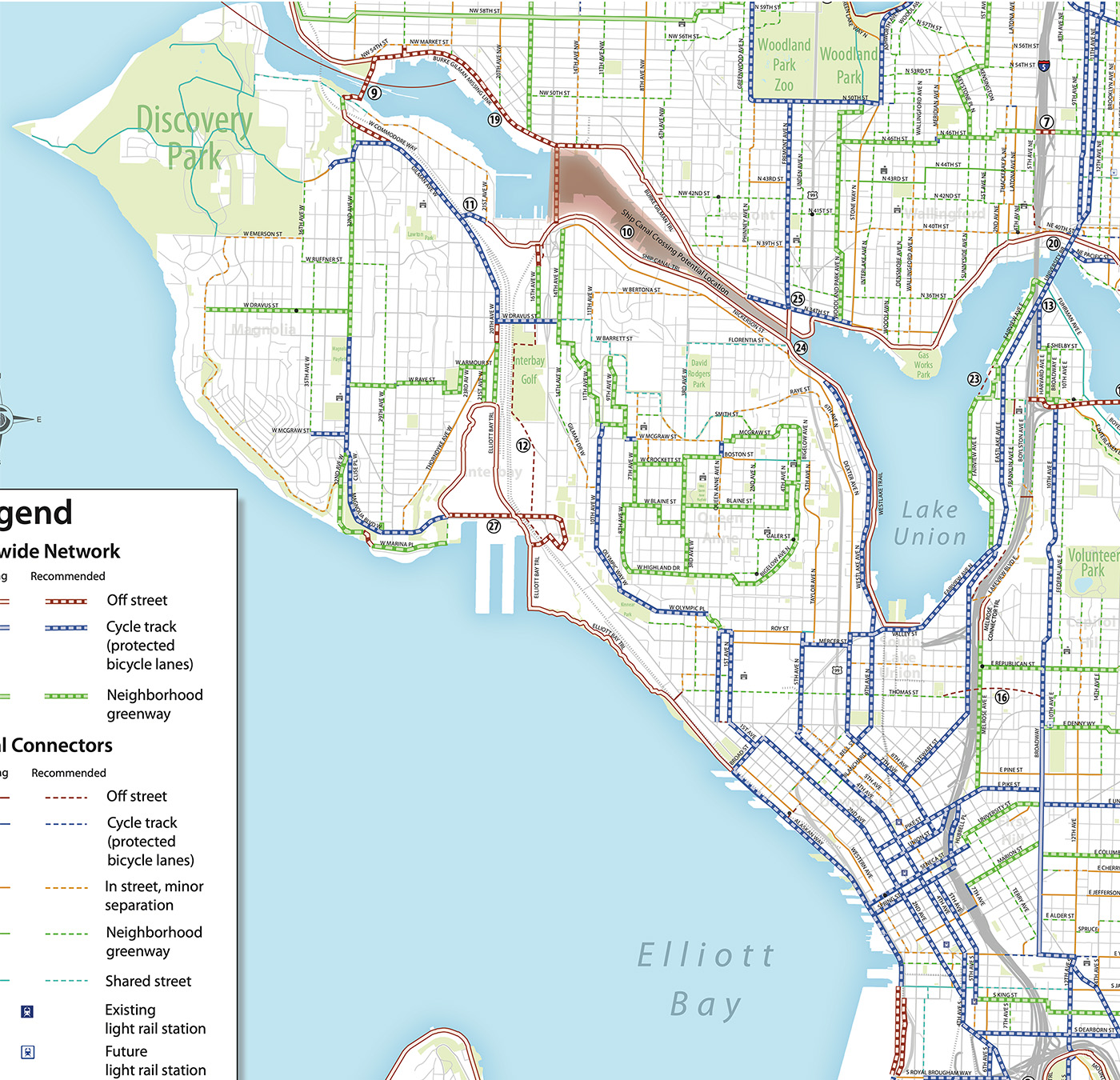
Downtown was one of the stronger areas in the 2014 Bicycle Master Plan. You have to remember that this plan was created before the 2nd Ave bike lane opened in fall 2014, and the idea that Seattle would build a network of protected bike lanes downtown was almost laughable. Even bike advocates were surprised when then-Mayor Ed Murray announced the 2nd Ave project during the Cascade Bicycle Club Bike Month Breakfast that spring, just a couple months after the City Council approved the Bicycle Master Plan. But seeing the 2nd Ave bike lane in action changed everything. It worked so well that much of the resistance to more downtown bike lanes vanished overnight. Before 2nd Ave, everyone assumed that downtown would be the hardest place to build bike lanes. But in reality, it may have been the easiest (not that it was easy).
All this is to say that there are not a ton of changes from the 2014 plan to the mayor’s proposed Seattle Transportation Plan bike map. Perhaps the biggest change is that it doesn’t look as impossibly ambitious as it did in 2014. But there are some really good additions as well as an interesting wishy-washy gray box on Stewart Street. Let’s start with the gray box.
Stewart Street is a diagonal street that makes a connection from Eastlake Ave to the downtown core in a way that no other street does. It is a massive opportunity to decrease travel times for downtown-bound bike trips. Today, biking on Stewart is a very scary experience, but it is so much faster than the alternatives that a lot of people do it anyway. Making Stewart safe for biking would be huge. The gray box is there because the STP includes a capital project to redesign Virginia and Stewart Streets, perhaps making Virginia a two-way transit route. But the details of this are all up in the air still, thus the gray box. But there’s another variable here that is worth noting in the plan: The Center City Connector Streetcar. Despite our arguments against it, the 2014 bike plan cut the proposed Stewart Street bike lanes short to avoid the section of Stewart that the streetcar would use. I argued strongly then that bike lanes were even more important near streetcar tracks. I stand by that today. But that streetcar may never be built, and if it isn’t, then there is no reason not to connect the Stewart Street bike lane all the way to 2nd or even 1st. Imagine a direct bike lane from the REI on Eastlake Ave to Pike Place Market. (Oh, and speaking of Pike Place, tell the City Council not to block funding for efforts to rethink the current state in which streams of confused tourists are allowed to drive their rental SUVs through the middle of our city’s most popular attraction).
The STP also wisely includes protected bike lanes on Western and Elliott in Belltown, past Pike Place Market and to the waterfront. These lanes would then connect to an extended Broad Street bike lane connecting 5th Ave and the Waterfront Trail near the sculpture park. These are all great concepts. A connection from the 4th Ave bike lanes to the 5th Ave bike lanes north of Memorial Stadium are still included, but they are now listed as a catalyst project. One issue is that the project requires using parking lot property currently owned by Seattle Public Schools, but that is all in flux as plans to renovate SPS’s Memorial Stadium evolve. So the city is making is clear that however that project turns out, we want this bike connection to be part of it. Good stuff.
Oh, and are those protected bike lanes on Jackson Street between the waterfront trail and 5th Ave? And bike lanes on 2nd Ave Ext/4th Ave S down to Dearborn? Yes please! There is so much potential for street improvements in this area. The city could do some really cool and maybe even iconic stuff at the intersection of 4th and Jackson to tie together King Street Station and ID/Chinatown Station. Imagine covering over that gap, removing some slip lanes and creating a public space right in the energy center of the city. The view from that weird triangle gap thingy is surprisingly dynamic, and we desperately need to create more sidewalk space here for post-event crowds. Building 2nd Ave Ext was probably a mistake, and traffic may flow better by removing some of the problems it caused. Hell, the city could probably delete the thing entirely. SDOT’s traffic counts show that it only carries about 13,000 vehicles per day, which is nothing for downtown, but it causes lot of problems by creating weird intersections with long signal cycles. But I digress.
It’s weird that upgrading the painted bike lanes on Valley Street near Lake Union Park is listed as a catalyst project. That one doesn’t seem so difficult, though perhaps they are suggesting that there’s an opportunity to work with Seattle Parks on an in-park route? I also love the catalyst project to connect SLU and Capitol Hill over I-5 at Thomas Street. It’s a tiny little line, but that would be a huge project that would surely need a lot of WSDOT and maybe USDOT assistance. It would need to be an engineering marvel.
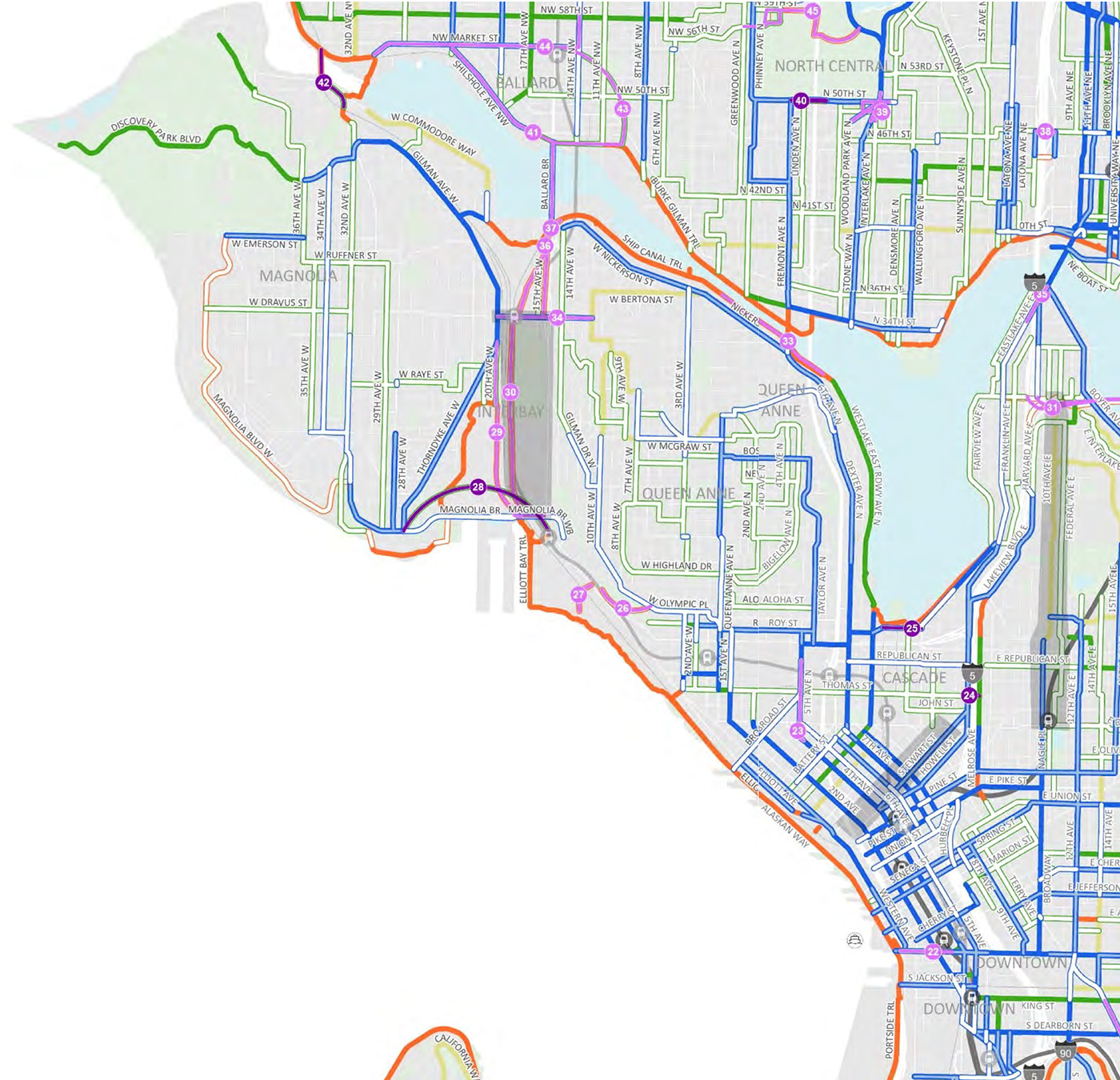
Queen Anne gets a huge makeover in the STP. It finally has protected bike lanes on some of the least-steep streets like Taylor Ave N. Yes, I know that street is not flat, but it’s Queen Anne Hill, and it’s the best we’ve got. The plan also calls for protected bike lanes on the counterbalance, which is kind of bad ass. Would these be the steepest protected bike lanes in America? The world? Joking aside, being able to make that climb without worrying about cars behind you would make it much more doable. I have climbed it, and it is not easy. But if you remove the stress and urgency of having people behind you, then you can go as slow as needed and stop to take breaks. It’s not as ridiculous as it sounds at first, is what I’m saying. And the street needs traffic calming, anyway. The STP also called for protected bike lanes on 6th Ave N/Raye St/Queen Anne Dr, which would be huge. This is that route that connects to the top of the hill on Dexter and then goes under Aurora. There just are not any other options for making this connection, but navigating this area on bike today is pretty stressful. This project would make the heart of Queen Anne feel a lot close to the rest of the city’s bike network. It’s still a big hill, but it’s not comically steep like some other options.
The biggest missing piece on Queen Anne is related to a much larger question: How will we connect the neighborhood to light rail stations in Interbay? The STP includes a catalyst project for a bridge along Dravus Street, but it does not include a complete Bike+ connection from the heart of the neighborhood to Dravus. I wish we have build a light rail station on Queen Anne Hill. What an amazing bike elevator that would have been. But I digress again.
The STP essentially punts on making any solid calls about what to do in Interbay. The whole area is gray, and every bike connections is listed as a catalyst project. I am not sure if this is a good or a bad thing. However, it does not currently show bike lanes on 15th Ave W, which is set to become even more of a destination center than it already is when the light rail stations open. There is, however, a catalyst project located in a space where there is no clear right of way. It calls for a “new trail from existing Elliott Bay Rail end below the Magnolia Bridge to the Interbay light rail station, located on the east side of the railroad tracks, west of 15th Ave W.” I think this project should add the words “or within 15th Ave W right of way” to the description because I suspect that may end up being the only practical option. Or perhaps there is a way to build the trail along the elevated light rail alignment? Either way, 15th Ave W is far too wide, which encourages speeding and leads to significantly more traffic injuries and deaths. We could make this bike connection and make Interbay safer for everyone at the same time. It should at least be included in the conversation going forward since so little about this area is planned at this point.
The plan also calls for protected bike lanes on the Magnolia Bridge as well as a vague catalyst project stating that whatever happens in the future with that bridge, there should be a bike connection. I wouldn’t be surprised if the city starts closing off lanes on the Magnolia Bridge due to its deteriorating state. I’m no engineer and don’t know the exact stress points for this bridge structure, but the city has closed the curb lanes on other stressed bridges in the past (like 4th Ave S in SoDo). So perhaps Magnolia Bridge bike lanes will end up happening out of structural necessity.
Which brings us to Magnolia. Not a ton of changes here. 34th Ave W gets a protected bike lane, and the bike lane on W Emerson St gets upgraded to a protected bike lane. The plan also calls for completing the connection to Discover Park. Perhaps the most intriguing addition is the catalyst project showing a bike connection that uses the rail crossing over Salmon Bay west of the Locks. The project description simply says, “In coordination with BNSF Railroad, connect 33rd Ave W Bridge in Magnolia to the Burke-Gilman Trail.” Sounds simple enough. Unfortunately for this project, BNSF decided against replacing the aging bridge and is instead about to embark on a rehab project, and BNSF materials show no mention of adding a trail. Perhaps the city is just adding this line in case BNSF decides they need to replace it after all? This is all to say that you should not hold your breath for this one.
Finally, W Commodore Way is currently shown as a “non-Bike+” route, but there is plenty of space for safe bike lanes on this street. There’s so much extra space that much of the street is currently lined with anti-RV concrete blocks and perpendicular parking. There are very few links to Gilman Ave W, so even though they look close together on the map they are not substitutes for each other. Council should consider upgrading this street to a Bike+ street in the plan.
Do you notice anything else in the plan (or missing from the plan) that I missed? Let us know in the comments below.


Comments
7 responses to “The 20-year bike plan for Downtown, Queen Anne, Interbay and Magnolia”
Thanks for the great write up! Can you walk me through how you know that (for example) “It finally has protected bike lanes on some of the least-steep streets like Taylor Ave N”
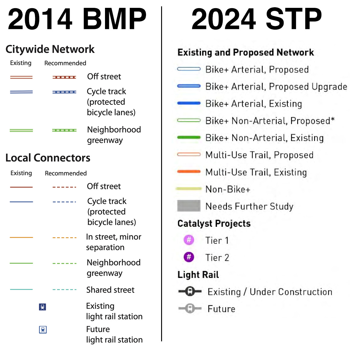
The STP says that the details of what a “Bike+” facility depends on the road context. If you go to table 4 it says a AWDT of 1000+ or a target speed of over 20 mph is required for a protected bike lane.
Are you (probably correctly) surmising that Taylor Ave N probably hits those targets? Is there a table of Seattle streets somewhere with their AWDT and target speeds that you’re cross referencing?
Those calculations you noted were factored into creating the map, which is why Taylor is a blue line (protected bike lane) instead of a green line (neighborhood greenway). Default target speeds in Seattle are 20 for non-arterials and 25 for arterials unless noted otherwise. So the fact that Taylor is listed as an arterial would also make it a candidate for protected bike lanes. But if you want to see traffic count data yourself, it’s in a map within SDOT’s annual Traffic Report (note that the year on the document is for the previous year’s data, so the 2020 report is the best one for pre-pandemic traffic patterns since the 2022 report is 2021 data, which is less useful): https://www.seattle.gov/transportation/document-library/reports-and-studies
Ah! I think I was overcomplicating it. Is it reductive to state that on the 2024 map blue is protected and green is not?
Sort of because the idea is that the green streets should be low traffic enough that a protected bike lane is not needed. In theory and sometimes in practice this is true, though the city has repeatedly failed to add diverters to keep traffic low and protect greenway routes from cut-through traffic.
I’m glad to see Taylor included. There’s a lot of car & truck traffic there and I’ve seen plenty of drivers veer into the bike lane, particularly on corners.
I ride the lower half, so my life will directly be improved :)
As for QA Ave, I don’t know if it makes sense. Grinding uphill, I use the sidewalk. Of course, for cargo bikes and other e-bikes, maybe the sidewalk isn’t good. But downhill, maybe, but I don’t know if I’d feel safer caged in a bike lane going 25 or in the traffic lane, the principal problem being right hooks.
The Westlake Cycletrack is not complete until it has consistent lighting all the way from Lake Union Park to the Fremont Bridge. Especially on the Fremont Bridge approach on the sidewalk, where oncoming car headlights hit northbound riders directly in the face.
The Elliott Bay Trail is not complete until it has consistent lighting all the way from Broad Street to the Marina. Especially in places where our night vision is impaired by floodlights from the terminal. If you’ve had to ride that path on a wet night you know what I mean here — the visibility situation can be nearly impossible.
For that matter the Elliott Bay Trail isn’t complete until the Port removes the insulting 5 MPH speed-limit signs.
It’s good to see that extending 2nd across Jackson is in the plan… but it was in the plan in 2014, too, and hasn’t happened. This is a sneaky-dangerous spot for southbound riders if they get stuck in the left lane and try to turn onto Jackson along with traffic flow, right into the streetcar tracks — turning into the lane the streetcar is in, definitely not how you want to be interacting with tracks! This has happened to me. I realized the tracks were coming in time to get across safely, but it really seems like a sharp edge in our bike network — a place where following the normal rules and conventions you’d follow in any other place puts you in danger without warning. If we get to the World Cup and this isn’t fixed some out-of-towner from a city where you don’t need secret knowledge to understand the bike network is going to crash on this thing.
One frequent difficulty with biking downtown is lack of support for basic turning maneuvers. The latest one I’ve run into is Pine at 2nd — if you need to turn right to go north on 2nd and you arrive at a green light what are you supposed to do exactly? It’s inconceivable that a major city’s transportation department would design any intersection without considering this question for cars, but SDOT does it all the time for bike routes. This is just the latest example.
I biked Stewart Street in the late 80s. SDOT placed sharrows on the north side with many buses. I used the left side. SDOT could have converted the left side parallel parking to a bike lane; most riders want to go south. Seattle owned the Pacific Place garage that needed the business. Later, the SDOT ROW manual says that bike lanes on one-way transit streets should be placed on the left side opposite the buses. See the pocket hazard on 7th Avenue nearside Stewart Street; routes 7 and 36 turn right to Stewart Street with bikes to their right nearly blind side. But SDOT continues to place them on the right side and require costly bus-bike humps or islands. See Roosevelt Way NE in 2016 and now 11th/12 avenues NE.