
The day before Thanksgiving, SDOT released a first look at their design concept for a Ballard Missing Link bike route alternative following 17th Ave NW, Leary Way and Market Street. The plan includes a 10-foot-wide “multi-use trail” on one side of the street as well as significant traffic calming and safety upgrades to Leary Way especially. However, the Market Street design points to why that short section will be by far the most difficult part, and the initial design calls for a significant reduction in the sidewalk space and removal of trees.
The team is working on a rushed schedule with hopes of reaching 30% design by the end of 2023. They will be out at the corner of NW Market Street and 24th Ave NW from 3–5 p.m. Tuesday (Nov. 28) collecting feedback. You can also complete their very short online survey.
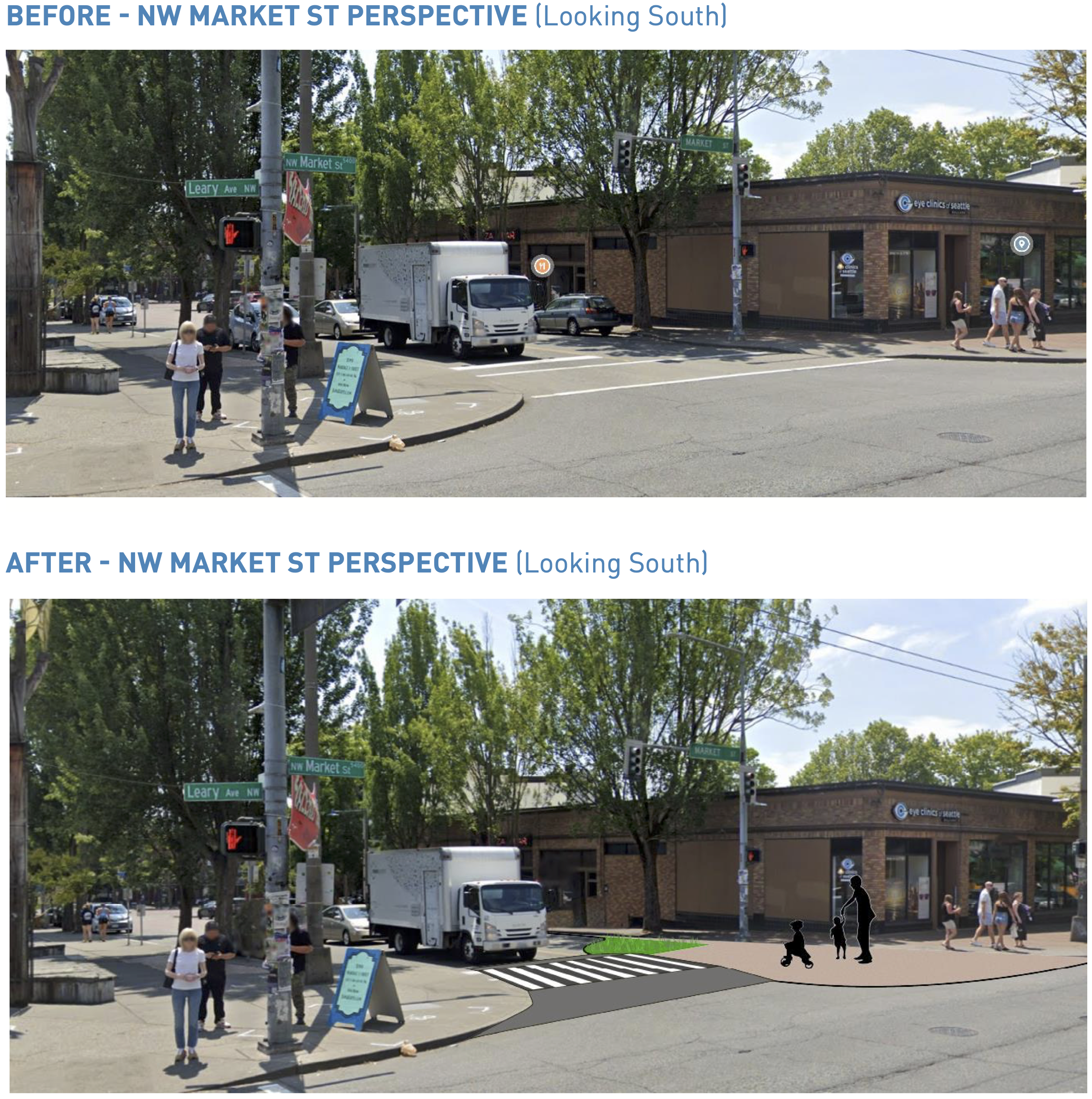
Market Street
Let’s start with the trickiest part: NW Market Street between Leary Way and 24th Ave NW, where the existing not-a-trail section begins. This is the heart of Ballard’s business district and has a ton of people on foot. It also carries Metro’s 40 and 44 bus routes. The 44 in particular is one of Metro’s busiest routes. Car volumes are not actually too bad, with SDOT measurements coming in at 10,300 vehicles per day in 2019. For reference, the street carried about 28,600 vehicles per day just a few blocks east near 15th Ave NW, but most people turn before hitting the busy business district. But there are a lot of turning movements, and traffic engineers will need to be careful that cars don’t back up in a way that impedes the bus routes.
The crux of the design seems to hinge on redesigning the bus stop to have an “10 ft wide pedestrian loading area closer to 22nd Ave NW,” and then using the existing bus shelter and tree planting space for a sidewalk-adjacent bike path. New trees would then be planted closer to the street. This could all be done without significantly reducing the space for cars and buses, allowing them to maintain some short bus-only lanes. However, it raises a lot of questions about how this will impact the walking experience as well as how to maintain separation between people biking, walking and waiting for the bus.
All these trade-offs and compromises are happening within the already-limited walking realm. But why are engineers so focused on preserving a four-lane design for a street running through a major business district with such high levels of foot traffic? Instead of pushing compromises onto the walking, biking and transit user spaces (not to mention the trees), let’s see some design ideas that utilize some of the 51 feet of roadway space. Instead of bus lanes for the bus stops, how about in-lane stops like already exist in other parts of the 44 route? They seem to work great in situations like these. Designers could also make significant safety improvements to all the Market Street crosswalks while they’re at it, shortening the crossing distances and slowing vehicle turns.
My worry is that there are so many people walking on this street, especially during busy hours, that they will naturally spill into the trail space. And if it is difficult and slow to try to bike through here and navigate around people walking on the path, then people will just go back to biking on Shilshole Ave. That is already an inherent risk in this whole Leary/Market project, since Shilshole will be the fastest and most direct bike route between the two ends of the Burke-Gilman Trail. That’s why Shilshole was overwhelmingly supported as the preferred route for the Missing Link during the extensive public outreach of the past decade. The only way it will draw people away from Shilshole is if it is so comfortable and safe that it is worth the extra time. This isn’t me being picky here, I’m just stating how things will work whether SDOT or I want them to or not. People will always bike the path of least resistance.
Leary Way
Now, for the good stuff. The design for Leary Way is extremely exciting. That street is wide, fast and on an angle against the grid, creating all these terrible intersections and terrible crosswalks. It is begging for a safe streets redesign, and the project team did not disappoint in these early designs. The street will be transformed into a much safer three-lane design for vehicles with one general purpose lane in each direction plus turn lanes, bus lanes and parking lanes as appropriate. By adding the 10-foot trail onto the existing sidewalk space on the west side of the street, the design will dramatically expand the walking realm and shorten all the crosswalks. But that’s not all. The design also includes intersection redesigns on the east side of the street to square up the turns, dramatically improve crosswalks and slow turning vehicles.
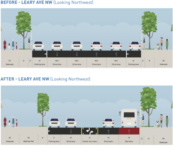
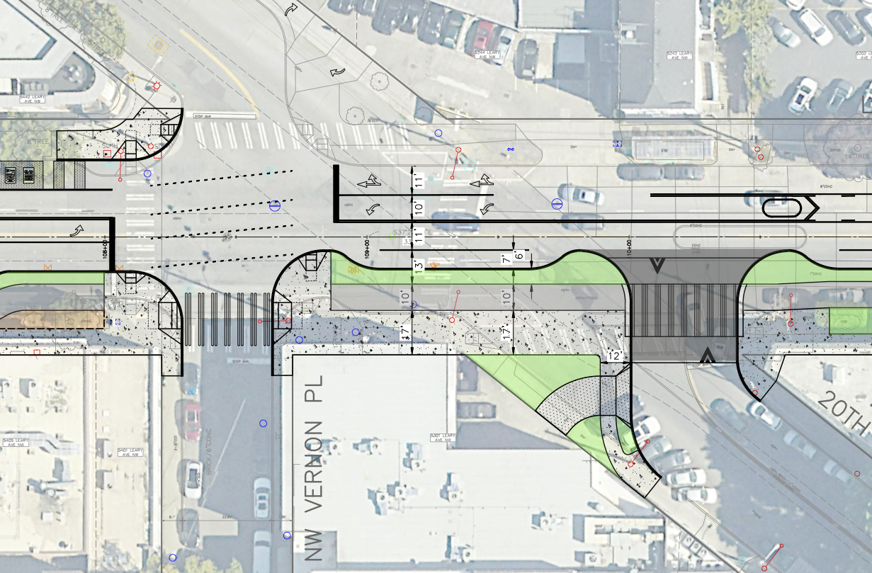
I’m sure there are some relatively small details to work on, but I am very excited by the Leary Way design. This would be such a dramatic improvement for this street. For example, look at the design for the strange and gigantic three-way intersection with 20th and Vernon Pl:
These kinds of changes might just make Leary a street people actually want to spend time on rather than a high-speed barrier separating businesses from nearby apartments. I would love to see the Leary strategy applied to the Market Street section.
Like the other segments, though, this design would result in a lot of tree removal. There do seem to be places where the trail could possibly route around the trees if parking were removed or lanes were shifted. I’m not sure. But I suspect tree loss will not be popular.
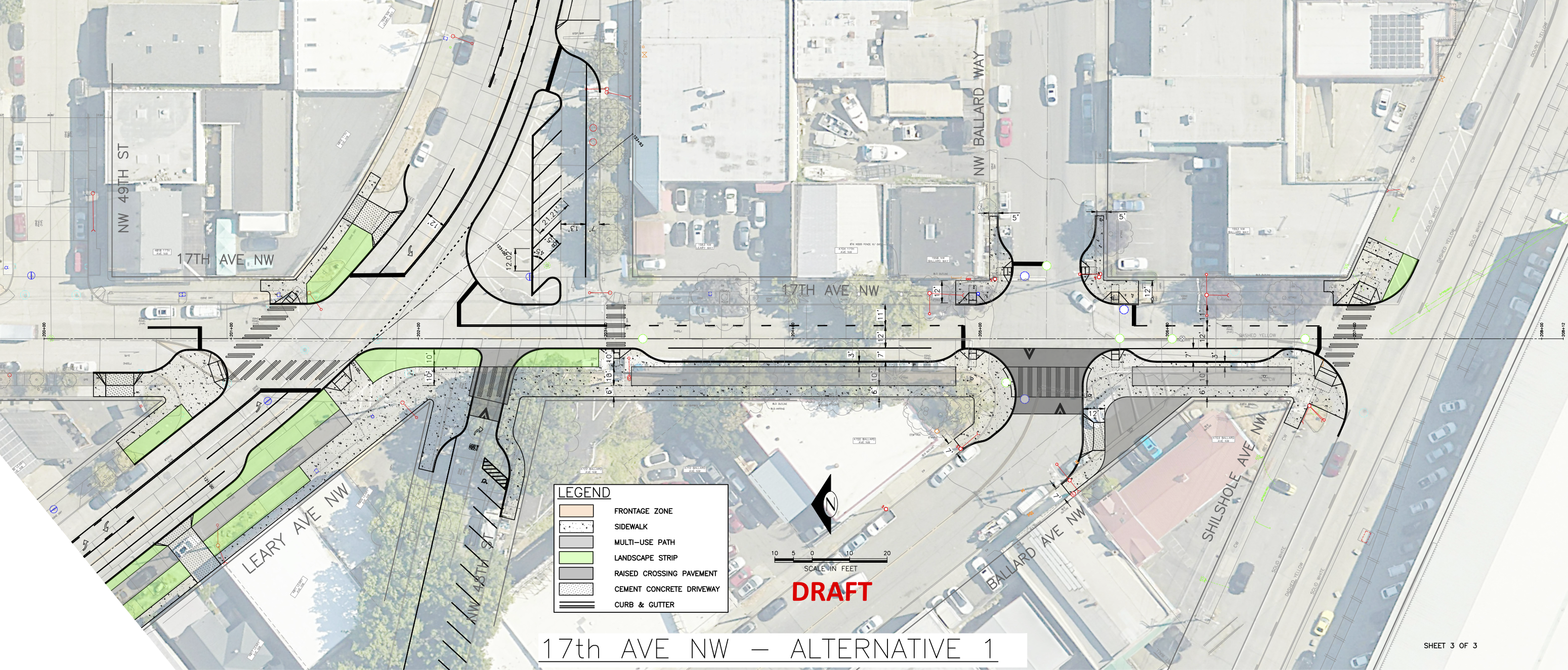
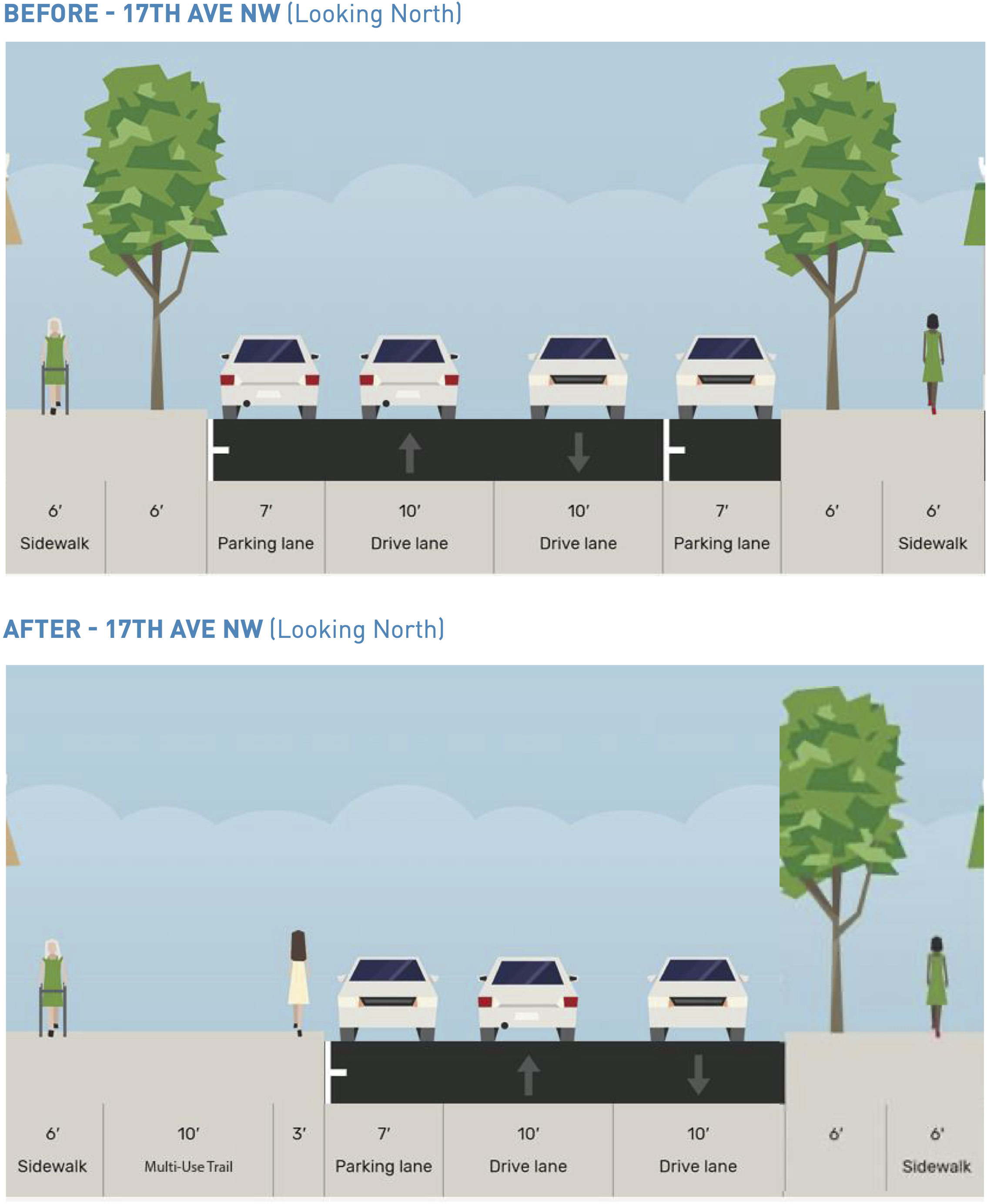
17th Ave NW
The planned route would connect to the existing bike lanes serving as a not-so-temporary bike route on NW 45th Street via a new trail on 17th Ave NW. The primary thing to note here is that there are 5 trees in the trail path. It’s really not a very busy street. I wonder if they could make it a one-way street or something to avoid more tree loss and curb work than is absolutely necessary. This is a part of the neighborhood that is already somewhat lacking in tree cover, especially the parts east of 17th.
Conclusion
You can scour the details in SDOT’s design roll plot (11 MB PDF). Other interesting details include some new angled parking in places, perhaps to offset any parking loss.
In general, I am ecstatic about the Leary Way safety improvements. Market Street seems very compromised in favor of preserving space for traffic, and SDOT can do better here.
The trail is a consistent 10 feet wide, which is below the standard of 12 feet. However, since it is next to a sidewalk, this skinnier width could still work. But it would need to be designed more like protected bike lanes and less like a multi-use trail. I think the brief must have specified “multi-use trail” for this project, but it’s just not the correct tool for this situation. A protected bike lane is more appropriate for these commercial sections with adjacent sidewalks.
I am also concerned about the bike and walk mixing zones at essentially every street corner. People walking and biking should be properly separated. Otherwise people waiting to cross the street will be standing in the way of people trying to bike the route, which is just not a good situation for anyone involved. I’m not sure where they got this idea for mixing zones, but this won’t work. The only places in Seattle where it is at least somewhat successful are place where people on bikes are waiting for a traffic signal (like 7th Ave at Westlake Ave). But the key is that people on bikes are not trying to pass through while people are waiting for the signal because people walking and biking all get the signal to go at the same time. Look at this example on Market where it crosses 22nd Ave NW:
The “trail” here is just people biking on the sidewalk, which is not a good solution for such a busy business district. I don’t think anyone has been asking for more sidewalk bike riding. People walking on the sidewalks won’t like it, and people biking won’t like it. Again, a protected bike lane is a more appropriate solution.
A great project is possible here, but SDOT cannot cut corners and compromise the biking and walking experience in order to get there. If they do so, the project will fail.


Comments
20 responses to “SDOT releases early design for Leary/Market bikeway, seeks feedback”
“I’m not sure where they got this idea for mixing zones, ”
The 7th Ave bike lane? Of course it doesn’t work, but that part seems to be conveniently ignored.
Glad someone is saying it. Seattle’s mixing zones (especially the ones on 7th) are based on the proposition that cyclists will be polite and attentive to an extent that the city would never expect of anyone else, and be perceived as the rudest people out there for it.
They need a raised crossing at 17th and shilshole, regardless of what happens with this project. It’s a nightmare for cyclists trying to get to the Burke. People making lefts/ rights from Shilshole onto 17th trying to either get to 15th or Ballard Ave are always turning extremely fast and not looking for cyclists. I’ve almost got hit their several times.
Also, beg button/flashing beacons on 46th and shilshole. Those are the two worst interaction points for cyclists and cars in Ballard.
I really wish they would just route it down Ballard Ave. Make all of Ballard Ave a one way street (as the last block already is. Car traffic is already very light and there are no bus lanes. Yeah, there is the Sunday market but that’s only a few hours on Sunday morning.
I would not consider traffic on Ballard Ave light. Narrow street, restricted sight lines from added open air dining structures, cars constantly looking for parking, pulling in and out while trying to avoid heavy pedestrian traffic, pedestrians crossing at every spot of the street. And that’s not even considering issues of navigating the weekly, year-around Ballard Farmers Market on Sundays and other special events.
To the proposed plan, yes, heavily concerned w sending bikes to basically ride on the sidewalk w pedestrians. Also, concerned w serious loss of parking in an already parking-stressed neighborhood that actively works to attract folks from far and wide.
Shilshole is truly the way to go as it avoids all the problems above.
Actually looks like they’re proposing to ADD 13 parking spaces in this design iteration
https://www.seattle.gov/documents/Departments/SDOT/BikeProgram/Ballard%20Bike%20Study/Leary_MissingLink_FactSheet.pdf
‘So overall the project design for the trail would gain
a net parking increase of 13 new spaces in the
neighborhood’
Agree: mixing bikes and peds on Market is very unhelpful. In fact, it’s worse than at present, sure to have more bike and pedestrian confrontations. The main *separated* Ballard bike route needs to be on Shilshole. Should have been done decades ago.
Endlessly litigating businesses and landowners should be ashamed, promoting gentrification pressing on (eroding) the maritime industrial area without solving bike/ped access to Ballard’s core business district OR bike commuting needs and access to Shilshole Marina.
For me, Leary is a hard sell. Too many intersections compared to Shilshole. That means I can’t bike through, but must stop, look, and reaccelerate. That’s not very efficient cycling. The nice thing about most of the BG trail is that you can ride smoothly for long stretches. It’s pleasant. It’s fun. Leary would be tedious.
The Market Street solution would work in Amsterdam where people are used to narrow bike and pedestrian lanes adjacent to one another but will be a disaster in Seattle.
17th and Shilshole is going to need an all-way stop. Conflicts with eastbound drivers turning left to get up to the bridge can already be a problem, and it’s the kind of conflict that can sneak up on you quickly if you don’t know to watch out for it.
This might seem like a minor thing, but… turning 22nd Ave into a glorified parking aisle kinda pisses me off. It used to be easy to bike to places on Ballard Ave. Now it’s a bit of a pain with Ballard Ave being one-way, but you can use streets like 22nd to get down there. With these changes I’ll have to detour around even farther! And it pushes more people hunting for parking spaces to do loops around via Ballard Ave.
OK, I get this is kind of a curmudgeon take, but hear me out: the whole point of having walkable neighborhoods is that you can take care of your daily needs on foot. In Seattle our walkable neighborhoods are filled with fancy/specialty stuff, which then is “destination” stuff, which means people want to drive there from all over the city. It’s backwards. Put the “destination” stuff you go to a few times a year in some inconvenient location. Put the stuff you need all the time in the walkable neighborhoods. Then you won’t have so many people trying to drive there because they could just as well walk to it in their own neighborhoods. I know we don’t actually get to control that by fiat, but… when we turn normal basic streets people can use into ultra-dense parking aisles it just encourages our backwards land use.
Echoing the comments that if this gets built as-is, I’d just continue to ride down Shilshole when I’m going that way, because it doesn’t require me to stop every block or two.
Also, the mixing of pedestrians and bikes is going to be a complete mess along Market. It’s already bad sometimes around the Nordic museum and the restaurants further west: people walking assume (rightly so, since there are no markings) that they have a nice wide avenue to stroll along, and take the whole space in groups. That’s great for walking crowds and for the businesses there, but it makes for a slow and annoying cycling trip. That area has a fraction of the people that central Ballard’s Market St. does, so this plan would be even worse.
I agree with all your points, John. The idea for a mixed use trail combined with a sidewalk and crosswalks on Market for something as popular as the BGT and as busy as Market is not workable. This will lead to accidents and blame being directed at the general cycling community if cyclists clip or hit people or pets. The trail should move into a fully protected (curbed), all ages, all abilities bike lane for this segment.
Just like with drivers, there’s a proportion of cyclists that ride way too fast for conditions, or are distracted. You already see this on the BGT, where some asshat (or pack of asshats) is trying to move up the Strava leaderboard on a sunny Saturday afternoon, swerving around kids and senior citizens. Or the dude on the 75lb fat tire ebike, blasting tunes on a bluetooth speaker and watching TikTok videos. And mixing them with similarly distracted people on their phones ambling along on the sidewalk, or with Fido on an extending leash, is asking for trouble. Pedestrians expect cyclists to zip by them on the BGT; most will glance over their shoulder if moving around a stroller, etc. They don’t expect a cyclist, let alone one moving faster than a walking pace, on what they will rightfully see as a neighborhood sidewalk.
All it takes is one senior citizen getting knocked to the ground and breaking a hip or losing a bunch of teeth; beyond the tragedy of someone getting hurt, it could set back trail building and safe street efforts for years.
This looks like a great way to widen sidewalks on one side of the street to 20 feet while failing to actually bridge the gap on the BGT.
Ped/bike traffic will mix in a very not ideal manner here which will make the “bike trail” ineffective.
I don’t think mixing bikes and pedestrians is bad per se but it should be done the right way. A great template for this is the BG trail from Husky stadium to 15th Ave NE. There are lots of pedestrians and lots of bikes and have rarely had any issue using that section (admittedly as a bicycle rider only). But I guess the market street section proposed will not be as wide as the section I mention near UW. The city is selling out the bicycle riders in favor of drivers. Nothing new.
I frequented that part of the BGT on foot between 2018 to 2020 and never had any issues. The key parts of its design that make it successful are:
1. The walkway is separated by a curb and is a different material, providing clear delineation between the walking and biking spaces. It uses a rolled curb, allowing people to pass between the two spaces when necessary.
2. The walkway is wide enough that people can comfortably pass by people walking in the opposite direction, even when walking side-by-side with others.
3. The bike lane is bidirectional and does not split, allowing faster bicyclists to pass by slower ones without entering the walkway.
The Westlake and 7th Ave bike paths fail on all three points. The NW Market St section of the BGT fails on points 1 and 2. I hope SDOT listens and revises the Leary/Market design to not generate unnecessary conflict.
it has been my thought that the trail was designed to be a nice, sightseeing pathway for non-motorized modes. With that in mind, I would want it to be in a quieter, less hectic and attractive route.
Along the North side of the ship canal along Shilshole avenue and along NW 54th street makes the best sense.
It is as out of the way as possible from motor vehicles and potential accidents and congestion.
Tom and the commenters have nailed it. The Councilmember Strauss notion will fail on NW Market Street. I hope SDOT does not implement it. There will be too much friction between pedestrians and bus riders on the one hand and BGT users of various speeds and two directions on the other. Note that the design retains the west to south left turn lane and puts all general purpose traffic and transit in a single lane. When the Kubly SDOT did that to Pike and Pine streets, transit was clogged in both peaks. More recently, NE 65th Street was slowed. At peak times, the 10-foot mixed use BGT will be jammed. Note the nice job the UW did to expand the BGT north of NE Pacific Street; they separated the modes. I fear SDOT may be using BGT funds for this study. Yes, the intersection of 17th Avenue NW and Shilshole has deserved a four-way stop for decades.
I agree that a trail along Market is a bad idea. In addition, the Leary/Market intersection doesn’t need any more complexity than it has now. Taking it up 17th Ave to a street north of Market would be a reasonable solution. 58th is already a bikeway. That would serve casual riders who want to be on an established route. Commuters will go the way that works for them.
Late to this convo but for crissakes, these designers need to stop mixing pedestrians and bicycle riders and e-bikers all in one path. It’s hectic, few people know the rules or show any politeness or understanding of etiquette, half of the folks have headphones in… it’s like allowing horse drawn carts and human powered pedicabs on the freeway.
This all plays into a huge part of why I loathe riding my bike around this city over the last few years.