
 Seattle significantly redesigned its city bike map for the 2015 edition. In addition to updating the map to include new bike facilities, the map icons and color scheme are easier to read.
And, of course, it notes the current locations of Pronto Cycle Share stations. Because Seattle has bike share, everyone! How cool is that?
You can download the PDF version of the print bike map from SDOT’s website. You can also have a totally free copy of the map mailed to your house by completing this online form (thanks WA Bikes!).
Other than some basic legibility changes, the overall theory behind the map’s routes are the same as previous years. This creates a good-looking map that can be useful for people trying to find a doable bike route, but it can also be a bit misleading about how comfortable people can expect their bike route to be.
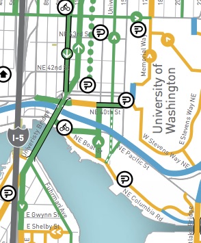
As with previous iterations of this map, my biggest complaint is how the map displays busy streets with sharrows painted on them. In the new map, these streets are marked as skinny green lines. Here’s the legend:
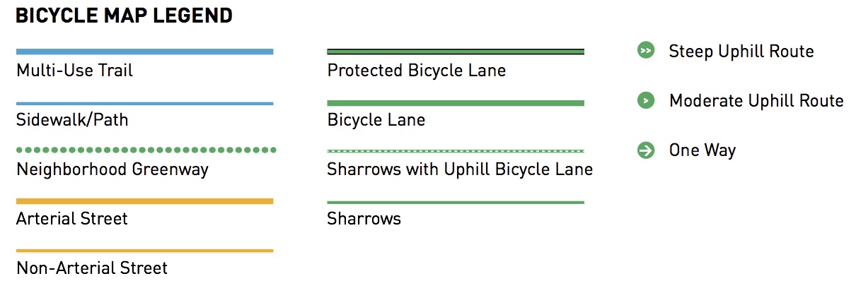 Since fatter green lines note bike lanes and green lines with black outlines note protected bike lanes, the skinny green lines for sharrowed streets visually imply that these are also good streets to bike on. Unfortunately, this is often very misleading.
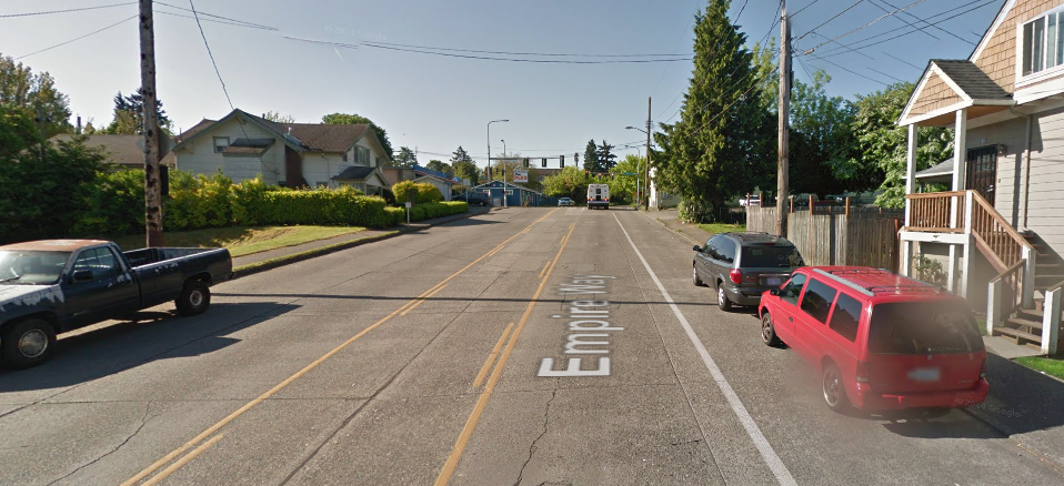
It also has the effect of making the map overstate the city’s existing bike-friendliness. While I would love if there really were this many quality bike routes criss-crossing the city, a great many of these sharrowed streets actually look like this:

The map also still includes old bike lanes that hardly really count anymore. You know those bike lanes that are really just extra-wide parking lanes, not even wide enough to have two stripes?
We should probably go ahead and remove those from the map until the city gets around to upgrading them to modern standards.
My suggestion for future years would be to change all the arterial routes that only have sharrows or outdated bike lanes to yellow like the rest of the arterial streets on the map. That way the real bike lanes, trails and neighborhood greenways will stand out better, and people can get a better idea of which routes will be the least stressful.
While I certainly wish all the green routes in this map were truly high quality bike routes (especially downtown!), it’s just not true. Yet.
As we reported last year, the city has considered redesigning the bike map according to stress level. In fact, the city’s online map provides this option. But that concept did not make it into the 2015 print version.
And, one last nitpick (seriously, I do like this map! I just want it to be even better): Why are the streetcar and light rail lines so prominent? Transit stations should definitely be marked, since many people will want to bike to transit. But marking only rail routes (and not major bus lines) seems of little use. Worse, it almost implies that these routes are also bike routes. In the case of the South Lake Union line, the exact opposite is true.
I would suggest prominently marking major transit stations, maybe noting which connections can be made there or if secure bike storage is available. But don’t draw streetcar lines on the bike map unless it is to tell people where they present a hazard (marking Westlake’s tracks as a hazard makes sense, for example).
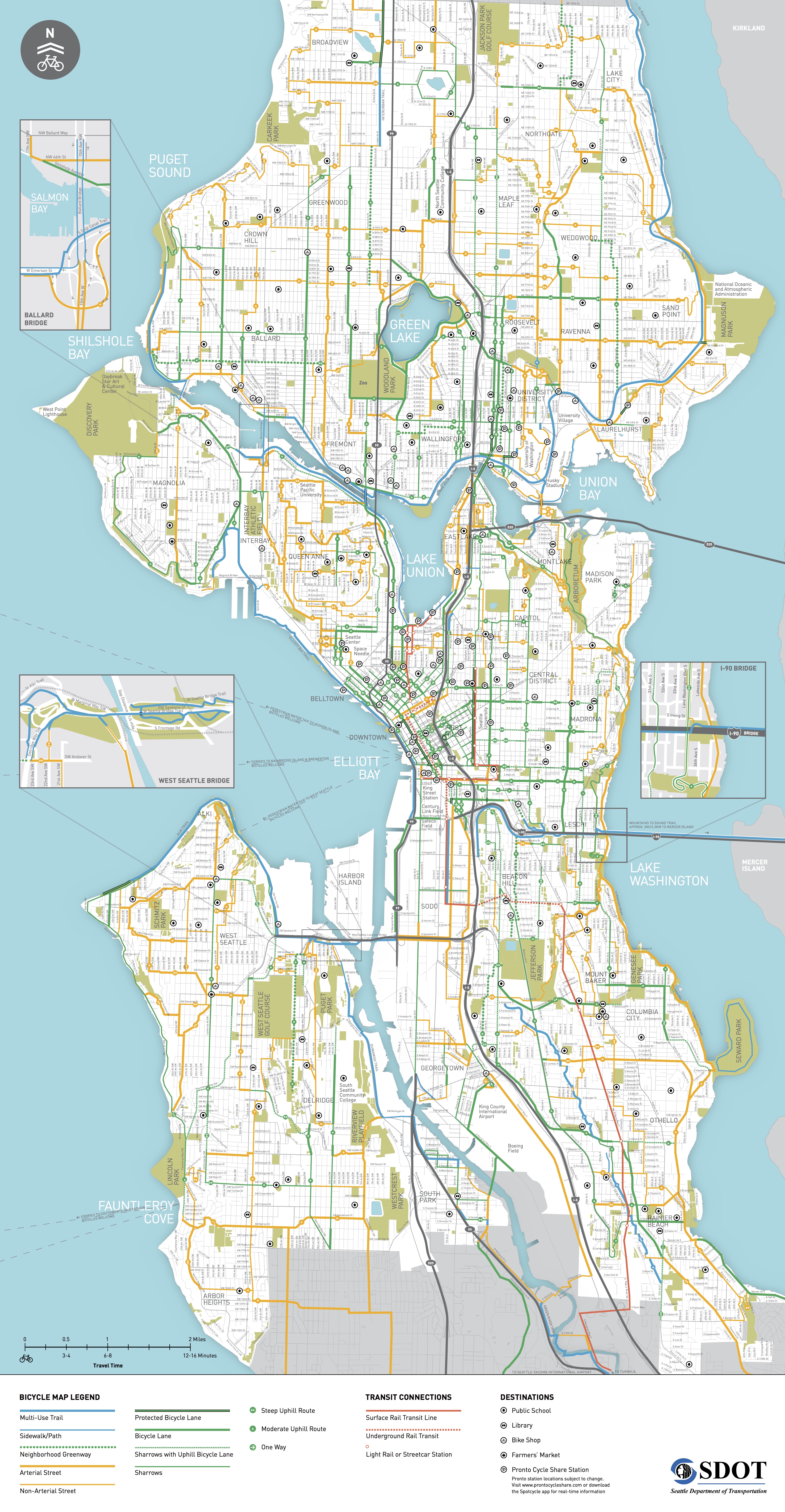
Below is the full map. Click the image for a large jpg version or click here for the full PDF.


Comments
53 responses to “Seattle’s 2015 bike map gets a makeover + How it could be even better”
I think it’s a great idea that the surface rail hazards are bold red lines. Not everything is prominent because it’s good, some things are prominent so you can avoid them.
Does anybody really want to ride on a street with open flange gaps?
But not all the rail lines are such hazards. The light rail on MLK, for example, is in its own ROW. Broadway has the bikeway. I agree red might be the right color, but really should be primarily limited to the dangerous Westlake section and maybe Jackson.
Probably Broadway, too, the street itself has serious rail hazards.
I’d tweak it to use the solid red line for in-street rails, and the dotted red line for all off-street rails, rather than just tunnels.
That’s a good suggestion.
Amusing wording by SDOT, “the track groove is just slightly wider than the typical bike tire” Really? “just slightly”?
Less-amusing wording, “Use the sharrow to guide where you ride within the lane. Remember not to ride too close to parked cars.” You can’t do both at once, not with all the door-zone sharrows the city slapped down when it first started using them. How about, “sharrows mark lanes too narrow to safely share with cars. Don’t encourage unsafe passing, ride towards the center of the lane, staying well clear of parked cars.” Not for the faint of heart because of occasional honking by ignorant drivers, but at least it’s safer and more comfortable than riding in the door zone.
Agree on all points. I was actually honked at by a metro bus for taking the lane a couple of days ago. They really need to train their people better.
On the bright side, SDOT has changed their policy on sharrow placement. (Only happened mid-November, so it hasn’t had much impact yet.)
On streets with parking, sharrows will be centered in the travel lane by default, rather than using the bare-minimum curb offset allowed by MUTCD. When sharrows have to be restriped, for regular maintenance or because of construction, door-zone sharrows will be relocated to the center of the lane.
No luck yet getting them to add the “BICYCLE MAY USE FULL LANE” sign that MUTCD suggests using with sharrows, so that motorists actually know what those bike symbols mean…
For a while there was a sharrow on NE 45th in Wallingford that pointed directly into a bus curb bulb. The sharrow predated the bulb, but when SDOT built the bulb it took them years to go back and repaint street.
Actually the bold red line is “Surface Rail Transit Line”, NOT rail “hazard”. At first I was thrilled to see no red in Ballard, but then I was like*: “that doesn’t make sense”, so I checked the legend.
The section on “Seattle bicycling laws” is interesting, “Come to a complete stop
at red traffic signals and stop signs”, so, that is a “bicycle” law, not a car law! (not that the two are mutually exclusive, but the fact they make a distinction is telling) that explains a lot!
Odd that they have a detail view for the Ballard bridge, yes, the bridge does have sidewalks, but as they are generally considered inadequate, it seems a bit odd they’d highlight them on a bike map, or perhaps the point is that one will indeed be on a (poor) sidewalk not any sort of dedicated bicycle infrastructure?
* http://www.xkcd.com/1483/
I notice that they added the symbol for bridges too (see the U Bridge in the first picture on this post)! Really helpful, since previous versions were misleading as to where connections could be made at the termini of bridges.
With all the bridges in the city, I hope they didn’t miss any…
The new color scheme looks great! The old one was confusing, with the prominent colors emphasizing non-bike infrastructure.
However, that legend is still way too long. If I’m looking at the bike map, I’m presumably looking for bike infrastructure. That means I don’t care about arterials or sharrows (I can look at any old map to find arterials). Sidewalk/path is a weird arbitrary group of things that makes no sense, and needs to go away (Ballard bridge sidewalk is *not* bike infrastructure; Green Lake feels like a multi-use trail). Signed bike routes from last year’s map has become “non-arterials”, which needs to go away as well; but that’s a longer discussion. Nor do I really care about the difference between different styles of bike infrastructure. I care about hills, and I care about low-stress vs high-stress routes. Bike lanes compared to bike lanes with uphill sharrows are all the same; higher-stress, for people comfortable with that, with all manner of variations on safety (some bike lanes are great, some are in door zones, some are too narrow, etc).
So there you go: Multi-use Trail, Neighborhood Greenway, PBL, and Bicycle Lane. Perhaps keep Non-Arterial Street for a few more years, until the existing signed bike routes are removed or upgraded to greenways.
Interlaken Boulevard will never have bike lanes of any kind and is more like a park road than a neighborhood greenway. But it’s still a useful and beautiful route. Lake Washington Boulevard is somewhat similar; parts of it get enough traffic that separation would be nice if we could find room, but there are many sections where that will just never happen, especially its wonderful hill climb sections. The Ave doesn’t have bike lanes and won’t for many years if ever. Ballard Ave… who knows what will ever happen there or when? Parts of 16th and 21st Avenues SW get little enough traffic that they’re fine bike routes without separation.
Is the Lake Washington Loop route west and south of the arboretum going to be imminently upgraded to a greenway? A continuous one that connects the Lake Washington Loop? Is the surface street connection of the Duwamish Trail likely to be upgraded any time soon? Will the sidewalk-of-Delridge connection to the bridge really be seriously called something other than a sidewalk? Is Fairview down by the floating homes actually destined to be a greenway?
A bike map of Seattle that omitted any of these routes wouldn’t be worth the bits it was printed on. A city with the geography and history of Seattle is going to have more than a couple types of good bike routes! The key is that all these different kinds of routes don’t need different colors in the legend.
I’ve always thought the transit properties of the city bike map were pretty illogical. If there’s a small number of transit stops you want to show on a bike map, it’s something like, in order of importance:
– Most popular range-extenders: 520/Montlake, I-90/Rainier, I-5/NE 45th
– Major downtown infrastructure: DSTT stations, ferry terminals
– Secondary range extenders: I-5/145th, Central Link stations
(This is where I’d draw the cut line)
– Transfer nodes with all-day expresses: Alaska Junction, University Parkway, Northgate TC, maybe something on LCW, maybe 15th/Market
– Transfer nodes without express service: East Green Lake, Ballard/Market
Also, instead of “Bicycles welcome,” by the ferry lines, a brief description of operating hours and frequency would be really useful!
My take: Vancouver has a extremely legible and useful bike map. Let’s just use that and stop flailing around trying to invent something better. Let’s spend time innovating in other areas.
See visual comparison: https://twitter.com/GordonOfSeattle/status/571395169175478272
Vancouver, Canada
1) Clearly displays the all ages and abilities routes by highlighting them in gold. Greenways are solid green.
2) Reduces visual clutter by using only one bike color.
3) Uses dashed lines to visually downgrade unfriendly facilities, namely sharrows and paint only bike lanes.
Seattle, Washington
1) All ages and abilities routes are not clear.
2) Lots of visual clutter and colors.
3) Neighborhood greenways are downgraded with dashed lines while sharrows receive prominent solid green. This is the opposite of Vancouver.
Agreed. There is no need to put sharrows on the map. I really see no value in a sharrow.
Too bad that the Mercer underpass PBL isn’t shown. I guess that this map was published just a week or so too early?
But without that facility shown, the absence of a connection from SLU to Seattle Center/Lower QA is really stark. It will be nice to see the surface portion of that project completed in order to re-establish some surface connections through that area. That tunnel, though…. Yeesh.
Well, it’s great to see SDOT spend money on _something_ that’s obsolete and utterly worthless even upon the moment they unveil it to the public.
We don’t get to see that nearly as often these days.
Something Seattle could have borrowed from Portland’s bike map(s): locations of drinking fountains and public restrooms.
Those are also “range extenders.”
Another useful element from Portland’s bike map that is missing on Seattle’s: Bold red lines indicating “Difficult connection (use caution, use sidewalk, or find a different route)”
This map is still quite disappointing and not very useful as a real guide to wayfinding around the city. Few of the routes that I actually use to get from my home at 25th and Madison to destinations all over town show up on this map. I use low-traffic neighborhood streets, some of which will eventually be Greenways but even without improvements, these routes are far less stressful than most of the bold green lines, both because there’s little traffic, and because I know how to avoid the steepest hills. If I’m going to an unfamiliar neighborhood, for example Sand Point, Magnolia or Crown Hill, this map can get me to the general vicinity but can’t help me find a low-traffic, easy grade to a friend’s house.
The details on bridges are confusing. This map does not tell you that the Ballard Bridge is the most terrifying on a bike – it shows a thin blue line for “sidewalk/path” – while the Montlake Bridge, which is crossed on a much less terrifying sidewalk, is marked with a thick orange line for “Arterial Street.” Fremont, which also has a sidewalk for crossing, gets a thick blue line for “multiuse trail.” It’s not clear that the Ship Canal Trail passes under the Ballard Bridge and does not connect with the “sidewalk/path” or that the I-90 trail is in a tunnel under 31st Ave. So.
It’s also maddening that the map doesn’t show entrances to parks. I know that this is a contentious issue since parks are not supposed to be used for “transportation.” But can’t a bike map at least tell us where we can enter the parks and show roads inside the parks that people can use whether riding a bike or driving a car?
I’m sorry, overall this map gets a D+ from me.
Exactly: it doesn’t give meaningful insight into where a non-cyclist (who presumably doesn’t know the routes) would feel safe riding a bike.
Why does this matter?
I have a physician friend who I took on his first bike ride in Seattle a few weeks ago. He is risk-averse (I would say “risk-normal”), wanted to try Pronto, and only wanted to ride on safe streets.
So we rode the Broadway protected bike lane to Yesler, walked on the sidewalks to 2nd ave bike lane, and then did the trail by the sculpture garden.
We did this because, really, I have lived in this city 8 years and have NO IDEA where else you would ride. It’s not mapped. Like most people, I’m not interested in risking my safety (or burning my scarce weekend time) to painstakingly map it all out.
Nice easy routes from Broadway to downtown aren’t mapped because they don’t exist.
Hey Al – Sure.
Actually, what we were looking for was “nice easy routes from ANYWHERE to ANYWHERE, other than the Burke-Gilman”.
(the reason we went to downtown is because that’s the only place I knew of any sort of safe-ish bike streets, e.g. the Broadway protected bike lane & the downtown one.)
There is no way, after having a generation to put together a good biking map, that this is any better then something SDOT published in say, 2003. What’s even more disappointing, the person authoring this post actually thinks it is an improvement. Clearly the person writing the post doesn’t remember the maps from early in the last decade. If he did, he’d recognize this map isn’t an upgrade and wouldn’t be grasping for straws.
When we stop electing officials who are not capacitated to acknowledge their limits (and who subsequently hire people who have no desire to actually design a good bike map, and who btw most of them don’t live in Seattle…), that’s when we’ll get a good map. You want a good map? Give it to an organization that designs them, not the SDOT. And if the SDOT is already hiring someone on the private side, they failed in using taxpayer dollars wisely.
Lots of bitterness about this map out there. Despite my comment above about not showing the Mercer PBL, I think it’s a distinct improvement over its predecessor. Creating a good map that clearly depicts a ton of useful information is hard work. Getting that onto a page that folds up into a pocket-sized map is harder. And when you’re dealing with information that, city-wide, is essentially block-by-block, and trying to depict that at this scale…well, you’re going to have to make some editorial decisions about what you show.
In the end, I think this is a reasonably good effort at depicting the high-level stuff. I don’t think it is intended to be represent the absolute best way to get from every Random Point A to every other Random Point B. Rather, it’s showing the major stuff so, on an unfamiliar route, you can leapfrog from one “facility” to another or at least know what you’re up against.
Ideally, we’d have so many true facilities that a map of them would be impossibly cluttered and almost superfluous because you couldn’t swing a spoke without hitting one. In that universe, the more useful map would be the Seattle Bike Hazard Map, showing all the places to avoid at risk of death. Unfortunately, we’re not there yet. So we get this map of the current state of Seattle bike facilities, which shows the high points, masks some of the real-world difficulties, but, overall, is pretty helpful for neighborhoods that we’re unfamiliar with.
A lot of the ideas in this comment thread are good, but recognize that there are limits to what you can put on a map like this, and that there are a number of ways to make a good map. There are more ways to make a bad map, and I think SDOT did a decent job of staying on the “good map” end of that spectrum. I can’t wait to see how much better this looks in three to five years.
A few thoughts on eliminating sharrows from the map, as proposed in Tom’s post and some comments above.
Implicit in this campaign to eliminate sharrows from the bike map is the notion that they are useless as bike infrastructure. And implicit in the idea that sharrows are useless is the assumption that everyone rides (or should ride) the same way and wants (or should want) the same type of facilities.
Since I happen to like sharrows in many instances, I object to this project to de-legitimize sharrows as a form of infrastructure. I ride the uphill bike lane/downhill sharrow combination every day of the work week and I appreciate the separation from cars when going slow uphill, and the opportunity to get out of the door zone and share the traffic lane with cars when going fast downhill.
I recognize that sharrows are not for everyone. By the same token, super-protected lanes with poor sight-lines may be fine for slower riders, but they are sub-optimal for me.
I would say that the campaign against sharrows is in fact part of an ideologically-driven project to advocate in every case for the most protected, most expensive and most disruptive option and to literally eliminate other styles of infrastructure and riding from the map. Call it “PBL correctness”? I support the project of making cycling accessible to more people by creating “comfortable” facilities, but I don’t think bike advocacy that excludes bicyclists who are ok with less-protected options is likely to be as effective as it could be. Why not recognize that different people ride differently rather than trying to enforce a particular style of riding by wiping the infrastructure that suits faster riders off the map?
Anyway, regarding the map, I want to know where the sharrows are so I can use them. Making them a different color is probably a good idea.
I think you give sharrows a lot more credit than they deserve. When I asked people I knew about them almost every single person had no clue what they actually meant. So if many people don’t understand what sharrows are for, they’re helping nothing at all. I know that’s a small sample size, but I wouldn’t be shocked if there were many out there who didn’t know either.
I find it hard to imagine that many people contemplate sharrows with that mixture of wonder and bafflement you describe, mystified by these enigmatic signifiers as if contemplating the meaning of Stonehenge. Do they mean you should ride a bike here? Or maybe the complete opposite? Perhaps you’re supposed to ride circles around them, like a maypole in an ancient fertility ritual? Tom uses a sharrow as the logo for this blog, for Christ’s sake. It can’t be that mysterious.
Anyway, I’m not sure what policy you’re advocating for. If you think conditions for bicycling in this city would be improved by removing sharrows, then you should lobby SDOT to do so, and we can go back to having bare streets without any indication that bicycling is appropriate there.
Some drivers don’t know a sharrow from a bike lane marking, and believe that Seattle has turned many lane-miles of city streets into bike lanes.
Some drivers, from mandatory-bike-lane states I suspect, think that bicycles are only supposed to ride as far left as the sharrow, and can’t use lanes without sharrows.
Incredible? Keep in mind that they aren’t in the driver’s manual, there’s no requirement for the average driver to ever re-take the driving exam, even when moving here from states with very different laws, and that some drivers are still on the road who never had to take a test to get a license.
SDOT did a lot to de-legitimize sharrows when it first installed them. Most of the first-generation sharrows in the city were much too far to the right, sort of a faux bike lane on streets where they city knew there wasn’t room for a safe bike lane. And, for whatever reason, SDOT doesn’t use the approved “bicycle may use full lane” sign to accompany any of its sharrows, as recommended in MUTCD.
The result is that sharrows in Seattle aren’t a safe guide of lane position for people on bikes, and they’re a source of confusion instead of information for motorists who have no idea what they symbol is supposed to mean.
Having ridden where sharrows were properly centered in the lane and accompanied by the “bicycle may use full lane” sign, I would say that properly installed sharrows *do* guide more people to bike further left, out of the door zone, and *do* remind motorists that it’s appropriate and legal for bicycles to ride in the lane.
SDOT has changed policy on where they place sharrows, now properly centered in the lane, but I still haven’t seen the “bicycle may use full lane” sign anywhere in Seattle.
@Josh,
The one place in the Seattle area I’ve seen a “Bikes May Use Full Lane” sign is over in Kirkland, on the northbound downhill segment of Juanita Drive. The shoulder is wide enough that I rarely feel the need to bike in the lane, so I’m not sure how much it helps there. It would do far more good on a street with no shoulder to bike on at all.
@Skylar: Is that sign on Juanita new? I don’t think I’ve ever seen it. Of course, descending northbound is a bit of a white-knuckle experience, so I don’t see much when I do it. The shoulder is wide enough, and there aren’t a ton of driveways and cross streets, but those there are have pretty awful sight lines from the shoulder. On the other hand, typical car speeds out in the lane are quite fast.
There’s a “Bikes May Use Full Lane” sign on Lake Washington Boulevard in Bellevue, west of downtown.
@Al,
I hadn’t noticed the sign on Juanita until sometime last year. I think it was added when Kirkland redid the lane striping, and added the bike+ped lane on the uphill, southbound side.
I slightly prefer sharrows. While there are plenty of places where the sharrows are in the wrong place (and this clearly needs to be fixed) the issue I have with bike lanes is that (a) they are in the door zone and (b) passing cars seem to believe that safe passing means simply being on their side of the lane stripe. In my experience, people driving cars pass me more safely on streets with sharrows than on streets with bike lanes.
Sharrows can be useful (especially for wayfinding), and in many cases are a better option than door zone bike lanes, but that doesn’t mean the bike map should show either of them. As others have stated, the “Bikes may use full lane” signs* are a much better option for educating motorists, and sharrows on arterials have the unfortunate effect of confusing novice bicyclists; it’s even worse to show them on a map aimed at people unfamiliar with how to safely get around an area by bike.
* Instead of sharrows, I would love to see an on-road paint equivalent of the “Bikes may use full lane” sign on arterials. More obvious to everyone what it means. For school zones, we write “20 MPH School Zone”; we don’t how pictures of school buses on the road and assume everyone knows that it means to slow down.
I don’t understand your statement that “sharrows on arterials have the unfortunate effect of confusing novice bicyclists.” How are they confused? (Unless you mean poorly-placed sharrows that encourage door-zone riding, in which case, I agree.) I don’t dispute that the lack of separation on busier routes is not welcoming to beginners. In fact, my whole point is that bike infrastructure is not one-size-fits-all.
I do disagree with the premise that the target audience of the map should be narrowly defined as “novices who are uncomfortable with sharrow-marked routes.” Even though I have bicycled in Seattle for years, there are areas of the city that I don’t know well, and for purposes of planning a trip to those areas, I would appreciate knowing all of the options. Likewise, if I go to a new city and rent or bring a bike, I want to know all of the options for getting around. It’s hard for me to fathom why we would actually censor the bike map to render invisible actual useful existing bike infrastrure that the city has spent years developing–and is used by knowledgable locals–simply out of concern that some percentage of the biking population won’t like it. This is where I feel like PBL-centric ideology is trumping pragmatism and common sense. Yes, the map should designate these routes clearly and maybe add a disclaimer that some are best suited to experienced cyclists.
In other words, let’s have more information, not less, so that more people can make informed decisions about where they want to ride.
Are you comfortable biking on any random 30mph arterial (where drivers obey the speed limit) without sharrows?
If the answer is no, then what is it about sharrows that makes the route more welcoming for you? Do you feel that NE 45th, with its sharrow treatment (and 4+ lanes of heavy traffic), is more comfortable to ride on than 40th Ave NE (with 2 lanes in each direction, slower speeds, and no sharrows)?
If the answer is yes, then why do you need a map to tell you which arterials have sharrows? You need a map that tells you which arterials are unsafe to bike on, and the city’s mapping of streets with sharrow on them doesn’t actually tell you that.
@Andres,
I actually do find 45th St more pleasant than 40th at some times of the day. 40th is never jammed enough to slow people down, so people frequently do 40+ mph on the hill. 45th is often a parking lot for cars, so biking there can be a lot more safe.
When I bike to work at UW from upper Fremont, I’ll take 40th from Wallingford all the way to 7th Ave since it’s early in the morning and traffic is almost non-existent. On the way home, though, I would never consider taking 40th all the way up the hill. Instead, it’s much safer and more pleasant to take Latona up to 42nd and bike through Wallingford itself.
Skylar, I was talking about 40th Ave NE in Bryant; not Wallingford. People do not generally go 40mph there. Drivers obeying the speed limit is a key point of my question..
@Andres – Got it sorry, too many 40th’s out there…
Andres, you posed four gotcha questions to me, but did not answer my question regarding a statement you actually made (what makes sharrows “confusing” to beginners?).
So, I hope you’ll forgive me if I presume to respond to your questions according to my own preferences. Regarding question 1, as to whether I’m comfortable riding “any random 30 mph arterial” without sharrows, I’m not sure how it’s relevant, but I do in fact ride streets such as 50th through the U-District and Madison over First Hill to downtown. Do they qualify as “random” arterials without sharrows, and if so, what’s the point? I don’t find it relaxing, but it’s worth it to me to get where I’m going efficiently.
To cut to the chase (and answer your question 2), I think where we disagree is as follows: you don’t think sharrows make riding on a busy street any safer or more comfortable. And I simply disagree with that. I think sharrows indicate to all road users that bicycles belong on that particular street. When I ride on a street marked with sharrows, I am reassured that everyone understands that I have a right to be on the road. For that reason, I much prefer a street marked with sharrows as compared to the same street without them. (Obviously, there is a limit–I wouldn’t like to ride on Aurora, for example, with or without sharrows.)
Moving on to questions 3 and 4, do I prefer 40th Ave without sharrows to 45th St. with sharrows? Of course. But this gotcha tactic–getting me to admit to preferring a relatively quiet street without sharrows to a busy one with sharrows–doesn’t prove that sharrows are worthless. The real question is do I think 45th is better with sharrows than it would be without them and to that I say yes. Likewise, 40th Ave. would be better with sharrows.
Now moving on to my own questions (to myself). Do I think 45th with sharrows should be on the bike map? Well, you have carefully selected as the exemplar one of the busiest and least welcoming streets in Seattle with sharrows, but I would still say yes because I cling to the quaint notion that the function of the bike map is to actually get people where they need to go. And sometimes that means picking the best of the bad options (e.g., I think 45th is better than 50th, even though I used to commute on 50th because it was more convenient). Much as I might prefer 40th Ave., I just can’t use it to reach the U-District. As I said earlier, it’s probably a good idea to put disclaimers on busier routes so that novices are properly warned.
But if you limit the map to novice-friendly routes (and eliminate *all* sharrow routes as you propose), not only will you deprive stronger riders of information about efficient ways to navigate the city, you will also have a very incomplete network that will deprive everyone of guidance in picking the best option when they try to get from A to B–even if the best option is far from ideal. I think that lack of information would be a sad disservice to people trying to use bicycles as transportation and would in fact put cyclists at greater risk.
In other words, I think the map should err on the side of inclusion rather than exclusion, and be offered as a tool for navigating the streets as they exist today, with the understanding that not everyone has the same abilitities and preferences. I don’t think it should be an aspirational or ideological document featuring a “curated” and discontinuous collection of showcase projects.
What makes sharrows confusing to beginners: In some places, they’re used for wayfinding (greenways). In other places, they’re used to direct people where to bike (crossing tracks). In yet other places, they’re used to inform motorists that people may bike there.
If you’re new to biking and expect sharrows to tell you where preferred biking routes are, you probably don’t actually want to turn onto NE 45th when you see the sharrows there.
If you’re new to biking and think that sharrows tell you where to ride, does that mean non-sharrowed arterials don’t allow or are not recommended for bikes? What happens when you’re biking along and the sharrows disappear? What about NE 45th, where the sharrow is only in the right lane? Are you not allowed in the left lane? Before you consider that idea ridiculous, recall that there are places (NE 40th going onto UW campus, for example) where both lanes get sharrows.
And so on…
As far as my “gotcha” question, you keep repeating over that I think sharrows are worthless. I never said that. They have their place. That place is simply not in the bike map.
We obviously disagree on whom the map should cater to, and that’s the core of our discussion. The map should tell you how to safely bike from one location to another. It should not compromise by throwing you on unsafe streets like NE 45th. If you must instead take the Burke to travel safely between Wallingford and UDistrict, the map should reflect that rather than pretending that NE 45th is in any way suitable for safe biking on (heck, it’s not even safe for driving on, in my opinion).
I didn’t carefully choose NE 45th. I picked a sharrowed arterial that I’m familiar with; I obviously avoid them normally. Use 35th Ave NE instead, if you like. A terrifying street where people drive like maniacs, and one of the few streets in Seattle where I’ve been honked at by drivers for taking the lane (ie, biking where the sharrows are). The only other NE street that is sharrowed for more than a few blocks is The Ave, and obviously that’s a different story since in-lane bus stops have made it closer to a pedestrian plaza than an arterial.
If the sharrows make you feel comfortable, that’s great – but I can guarantee you that for someone who is biking in Seattle for the first time and trying to find their way around, sharrows will not make them feel comfortable on NE 45th, 35th Ave NE, Latona, etc.
I think this has been a good dialogue. I have only one further contribution. What about designating routes on the map according to ability-level as Gordon Padelford suggests above (in connection with the Vancouver map). Would that address your concern (which I share) about getting beginners onto routes that they aren’t prepared for, but at the same time accommodate my goal of having a more comprehensive set of routes that includes busier but more efficient sharrow-marked routes that stronger riders may want to use by choice (and others may end up using for lack of a better option).
I would even suggest adopting the green/blue/black (easy/intermediate/expert) color coding that ski areas use, just to make it clear that not every route is going to be comfortable to every rider.
Sure, I would be fine with that. I seem to recall SDOT creating an online map that did that, though the details are hazy. In the form I saw, it wouldn’t have transferred well to paper.
I *love* the idea of ski grade colors.
Indeed, and one can voice this opinion without calling into question all the other good that pro PBL people do, but one I suspect you cannot voice this opinion without at least some considering you an elitist. “Any and All Abilities” has become the mantra, and setting aside whether it’s the right standard, it has the ironic side effect of marginalizing those of us (a-hem, who’ve been cycling the mean streets of Seattle for [quite] a few years now) who may click into our pedals and just want to get places.
As a fellow pedal-clicking commuter for these many years, I appreciate your comment and the warning about being seen as elitist :) I also understand that catering to All Ages and Abilities may mean constructing some facilities that are not optimal for going as fast as I would prefer because they are more focused on providing “comfort” and a sense of protection. Compromises are necessarly in the real world and I’d like to see more people take up bicycling as an alternative to driving. So, if that’s what it takes, I’m willing to accept it. However, at the risk of beating a dead horse, what I don’t think is necessary is to literally *exclude* from the map other kinds of infrastructure that already exists and that serves some people well. I feel like that is the real “elitism”–assuming that there is one right way to ride and everything else should just disappear. I don’t think that kind of marginalization is natural and inevitable, nor is it helpful.
I believe a true all-ages-and-abilities street would include both some form of separated facility for slower and more timid riders, and clear in-street accommodation of faster, defensive riders.
As the Dutch Cyclist’s Union has pointed out in advocating this approach, fast cyclists make cycletracks unwelcoming to more vulnerable cyclists. Their solution is not to force faster riders to slow down, but to allow riders to choose between the street and the cycletrack.
At the same time, it would be useful to distinguish these different types of accommodation clearly and consistently on a map. Perhaps variations of green for separated facilities, variations of blue for in-street facilities, variations of orange for streets with above-average hazards, etc.
By itself, a sharrow doesn’t do much for safety, even if it’s properly centered in the lane. But if there’s a coherent plan behind the placement of sharrows to identify favorable routes for in-street cycling, those routes should be identified on a map.
One point I would agree with, many streets with substandard bike lanes should not be identified as having any bicycle-specific infrastructure. I’m thinking of the old 2nd Ave Bike Lane of Death, or South Dearborn, where the bike lane isn’t even wide enough to completely contain the bike lane marking. The only safe place to ride on that street is in the travel lane, but the presence of the substandard bike lane makes some drivers more likely to harass people on bikes.
There should be some review of legacy bike lanes to identify streets those that make the streets worse than if they had no bike infrastructure at all.
[…] map makeover: Seattle’s official bike map just got a big overhaul. Tom at Seattle Bike Blog breaks it down for us and says how it could be even […]
The key to making Seattle more bike popular is to show people how to avoid the steep hills and heavy traffic streets with no bike infrastructure. Going to green lake north seattle there are a lot of ways to get there, Arora bridge is very unsafe for cycling, sidewalk is to narrow, no shoulder and vehicles coming out of the conner at 40 mph might not have time to stop and hit you, queen anne hill is steep and long. The easiest and safest way to get there( don’t remember every last detail, but stone way is a gentle hill compared to queen anne hill).
[…] We were pretty critical of the 2015 map because it overstated the completeness and comfort of the city’s actual bike network. Busy streets marked with sharrows were given nearly the same prominence as streets with bike lanes, for example. Neighborhood greenways were dotted, which downplayed their comfort level. Looking at the 2015 map above, you might think NE 45th Street is a good bike route. Then you’d end up biking here: […]