
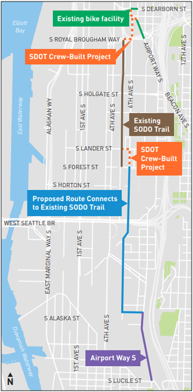
The design for the Georgetown to Downtown Safety Project, which will build a long-awaited and sorely needed bike connection, is nearing completion. The biggest changes are that the route will now access the SoDo Trail via S Lander Street rather than S Forest Street, which the SoDo Business Improvement Area requested. They have also revealed their plan to connect the SoDo Trail to downtown via S Royal Brougham Way and 6th Ave S, which is currently closed completely where it passes through the Home Base-Salvation Army shelter.
The schedule calls for final design to be complete soon and for construction in 2024.
SDOT is hosting a meeting 6 p.m. tonight (Nov. 30) to discuss the latest changes. Details for joining the meeting:
Join us for a virtual public meeting on Thursday, November 30 from 6 – 7 PM to hear about project updates. We’ll highlight what’s new in the design plans, share more about the outreach we’ve been doing with the SODO Business Improvement Area (BIA), and host a live Q&A. We hope to see you there!
When: Thursday, November 30 | 6:00 – 7:00 PM
Where: Zoom Meeting
Call-In Option: Prefer to join by phone? Follow these instructions:
Dial: +1 (253) 215-8782
Enter Meeting Number: 872 7061 6400


Comments
4 responses to “SDOT is nearing final design for the Georgetown to Downtown bike route”
This looks good in theory, but the devil’s in the details. It’s also disingenuous for SDOT to refer to this as a “Georgetown to Downtown bike route.” I note that the map stops right at the north edge of the Georgetown business district on Airport Way S. This seems bizarre, given that folks traveling south by bike between SODO and downtown to Georgetown, and those traveling from Beacon Hill or Rainier Valley into Georgetown via Albro, are going to want to, well, ENTER Georgetown. The point is to have a route between Georgetown and Downtown, not the edge of Georgetown.
What are you supposed to do when you get to 13th Ave S (traveling northbound) or Lucile (traveling southbound)? Get off your bike and walk for half a mile on a narrow sidewalk? This unfortunately seems to continue the city’s trend of stopping bike routes short of where anyone wants to go when they do bother to put any infrastructure in South Seattle. This is particularly notable on the highly underutilized bike lanes on Swift / Myrtle / Othello; the lane disgorges riders into traffic right by the I-5 on-ramp on the north end, and does the same a dangerous block short of the Othello light rail station on the south end.
The Urbanist flagged this concern too in an article on this proposed route last year (“No connection through Georgetown itself is planned”, https://www.theurbanist.org/2022/05/21/plans-advance-for-a-safe-bike-route-between-sodo-and-georgetown/). At the time, the explanation was just that it was difficult and expensive (and potentially fraught with controversy if parking spaces would be removed).
I wanted to sign onto this Zoom so I could try to ask about lighting on the SODO Trail but I had other stuff going on. Weirdly there’s a “pedestrian lighting plan” in the 60% design but only for a tiny portion of it (maybe the short sidewalk-based part of it?). I mean, obviously, they’re not really going to put lighting on an off-street bike path in Seattle, but I have to keep asking.
I’m also pretty curious about the connection between downtown and the SODO Trail. It’s not really possible for it to be good with all the zig-zagging around, but there’s a pretty big range in what’s possible. Maybe how good it is will depend more on signal timing than layout.
Thanks for brining up the zig-zag. I (maybe) understand the constraints SDOT has to work with. But it seems many of their projects are compromised with these zig zags. When I encounter one, I simply end up riding in a traffic lane. That works ok for me, but it defeats the purpose of getting more riders on the road.
I think, if riders end up stopping a lot and watching other traffic go by, it’s demoralizing.
Signal timing could help, I suppose. But a good base design would be best.
OK, so this is one of these things I try to look up from time to time and just can’t find any information about… what’s the deal with the Home Base shelter in SODO?
For one thing, there’s the bike access picture: this thing closed 6th Ave S and made access to the SODO Trail much worse. Was there any outreach around that? I follow bike news fairly closely and the first I heard of it was when I saw it in person when I had to divert around it out to Airport Way.
But then there’s also the shelter aspect. What’s going on in there that requires a fenced perimeter? That seems like the kind of thing that should require some public justification. I don’t follow these issues as closely as bike news but I try to basically keep up and stay informed and… IDK it seems like a shelter that big is something that should be part of public discourse at least sometimes? It feels like an informational black-hole kinda similar to a jail or prison. And I don’t want to get conspiratorial about it, like… maybe there’s information I don’t know how to find. It just seems weird.