
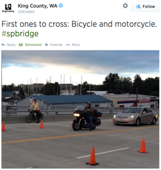
 The rebuilt South Park Bridge is now open, improving access to the neighborhood and creating a link in what could someday be a very bikeable place to live, work and play.
For at least the first week, cones will guide motor vehicle traffic into one lane in each direction, providing a rather luxurious buffer area for the bike lanes painted on the bridge deck, West Seattle Blog reports.
If traffic flows well without the extra lanes, perhaps the city could maintain the bridge as two lanes, at least until demand requires them to expand it (if that happens). The buffer area will make it much more comfortable for people waling and biking, and having fewer lanes would reduce collisions and speeding.
The bridge opened with pretty cool fanfare Sunday, including a day of car-free access, fireworks and some luchador wrestling matches. Josh Trujillo was there to capture some great images for the PI.
The bridge is only one fairly big South Park access project this year. The city also plans to create a somewhat skinny trail along S Portland Street to help connect the neighborhood center to the Duwamish Trail.
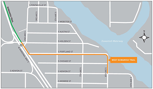 While only ten feet wide, the trail is hardly up to standards for a mixed-use trail (12 is typically the minimum, though there are plenty of well-used trails skinnier than that). The trail will be a welcome way to avoid truck traffic, especially during working hours. Plus, the trail is part of a much-needed paving project to fix S Portland Street, which is a strong contender for the prize of worst-paved street in Seattle:
The trail project also provides a great opportunity for the city to prioritize a neighborhood greenway on Dallas Ave, 10th Ave and S Kenyon Street, as is noted in the Bike Master Plan:
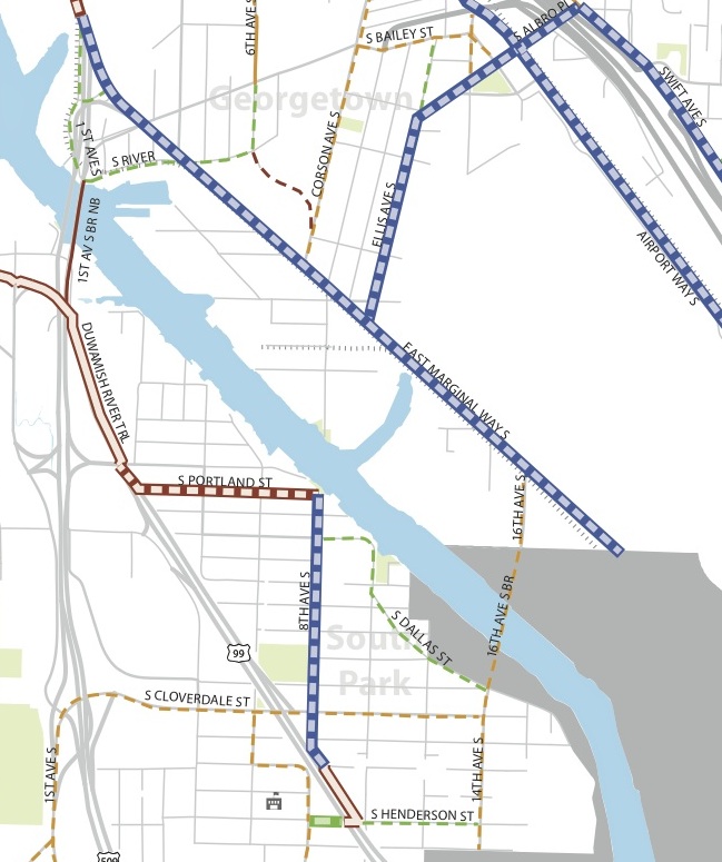 It’s also a good reason to prioritize the Airport Way and E Marginal Way protected bike lanes, which are required to connect South Park to Georgetown and Georgetown to downtown. And, of course, Seattle and King County need to partner to connect South Park and the Green River Trail, which starts tantalizingly close to the south of the city limit.
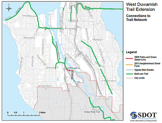 Construction on the S Portland St trail will start this summer and should be complete by December. More details from SDOT:
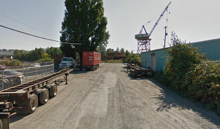
The West Duwamish Trail will soon be extended through the South Park industrial area, in a project that combines building a trail where there are no sidewalks, a road where there is no asphalt or drainage – where storms leave small lakes. The work, to be done by Gary Merlino Construction Inc. will begin in June and likely finish by December of this year.
The project will stretch from the current southern end of the West Duwamish Trail at Second Avenue South and South Holden Street to Eighth Avenue South and South Portland Street, past stalwart industrial firms such as Gear Works, West Coast Wire and Rope and Flamespray NW.
The ten foot wide trail will be separated from the newly constructed roadway by a 3.5 foot wide buffer zone. It will cross driveways leading into warehouses, factories and machine shops along South Portland Street, which will be illuminated by newly installed lights between the trail and the private property to the south.
The project will bring Seattle’s Duwamish Trail just that much closer to King County’s Green River Trail and bring the area that much closer to having a fully integrated recreational bicycle trail network.


Comments
11 responses to “South Park Bridge is now open, bike lanes ‘protected’ for a week”
Yay for connections… someday
It is great to hear that the city is working on connecting trails together. The Duwamish trail is really an orphan. My wife and I started at Muy Macho Tacos in South Park heading North. The path through South Park was pleasant enough but vaguely marked and just sharrows through the heavy truck areas. The Duwamish trail itself is nice and there are some tucked away parks to explore. The horrible part is that it just ends abruptly in an area with no sidewalks. The trail expects you to just brave the traffic of Marginal way with no shoulder or anything. Right when you need a trail the most, it vanishes and dumps you into the truck traffic all the way to the W Seattle bridge.
It’s not well marked, but when the trail ends on the east side of the street, you are supposed to cross the street (the crosswalk light is very responsive) and then take the sidewalk on the west side of the street for about two blocks and then take what is basically the alley past the scrap metal yard, then a small industrial street up to the bridge.
Like I said, not well marked, and not a great solution taking the sidewalk for a block or two (particularly with a crossfit gym now on that block!). But, if you aren’t comfortable with sharing Marginal for those 2-3 blocks, there is a (poorly) signed alternative that is safer.
Another thing right around there is the trail along the east edge of the new waste transfer facility. It nearly connects to the intersection of Marginal and Holden (where the Duwamish Trail currently ends kitty-corner) but ends in the weeds just short.
When I was growing up in the suburbs of Chicago there was a summer when everyone in my family had jobs in different places. We actually ended up needing to get an extra car for want of safe bike access to an industrial area a mile from our house (as the crow flies; one of my brothers worked in there). Here in Seattle many industrial lots have incomplete or disconnected paths around their perimeters. They come so close to providing bike connections to industrial jobs and across industrial areas and fall just short. This is one that was only recently built; it really should be connected up to that corner!
I’m very excited for some fresh pavement on Portland St.
Luckily I rarely encounter traffic in that area during my normal commute hours.
It will also be nice to have some bridge alternatives to S 102nd St Bridge & 509/99 Bridge.
It will be so nice to have a smooth surface along Portland St. The roads through there are crazy! I will be nice when one day the Duwamish Trail connects to the Green River trail. Right now that route is not very family friendly and I would love to bike from West Seattle to the Green River trail with my family.
That is also great the new South Park Bridge is opening. Even worse than Portland St. is finding a comfortable route on the north side of the South Park Bridge. I feel as though anything south of Spokane St. is really really unfriendly to bicyclists. There is so much room on Airport Way, it would be great if they could add a protected bike way on that road!
I’m curious about why they wouldn’t have made that an “actually” protected bike lane. It seems like the wall and rail could have been installed just as easily on the car side of the bike lanes. Was there an engineering reason for not doing that, or was this a missed opportunity?
I’ve been asking the same question. The response I got from SDOT was:
“The decision was made during the design process in 2007 based on the input from SDOT and the Seattle Bicycle Advisory Board. At the time there was a Bicycle Master Plan that showed bike lanes as the future facility. The new bridge includes painted bicycle lanes as well as a sidewalk. The sidewalk includes physical separation from traffic and bike riders may use it if they do not feel comfortable in a painted bike lane. This provides the accommodation for all ages and abilities.”
So basically, this was a missed opportunity.
See the comment here: http://sdotblog.seattle.gov/2014/06/11/monday-june-30th-south-park-and-georgetown-reunited-and-it-feels-so-good/
…sigh…
I wonder if adding bollards is in the cards?
A week of protection is better than nothing, I suppose.
That said.. Look at the ADT stats from years before the bridge closed.
2008: 18100 ADT (http://www.seattle.gov/transportation/tfdmaps08.htm)
2006: 18300 ADT (http://www.seattle.gov/transportation/images/06tfdgrid6.gif)
2004: 17300 ADT (http://www.seattle.gov/transportation/images/04tfdgrid8.jpg)
Those are well within the 20-25k limit requirement for a 2-3 lane road diet. In other words, based on trends from the old bridge, the new bridge doesn’t NEED 4 lanes. Since it’s a bridge, you certainly don’t need a center turn lane.
SDOT could do the cheap thing and keep some cones/bollards/delineators there until/if demand requires 4 lanes, as Tom mentioned in this blog post. Or, they could open it up to cars, get everyone used to 4 lanes, and then have to spend $100k-$250k/mile to restripe the roadway for 2 lanes when they realize that it needs a proper road diet.
I think King County would be in charge of that, but you’re so right. And once the freight traffic returns and makes South Park a thoroughfare for semi-trucks once again (if there was any benefit from the bridge closure, it was a respite from the loud, ominous semi-trucks barreling through South Park along 14th), King County will have to convince the freight community that a road diet is a good idea… :/
Makes me wonder how much more quickly and cheaply they could have built the thing if they just made it half the width it is now. But that’s water under the bridge I guess…pardon the pun.