The Puget Sound Regional Council recently released its list of recommended regional Transportation Improvement Program projects for 2013. The list includes road repairs, transit improvements and, yes, some complete streets projects.
Here’s a quick look at some of the bike-related projects to make the list. You can send the PSRC comments on any of the projects. You can also check out more of the projects on this map of 2013-2016 TIP projects.
Westlake Cycle Track
The biggest bike project that jumps out from the list is funding for a cycle track on Westlake Ave between the Fremont Bridge and South Lake Union Park. Former Mayor Greg Nickels has often mentioned the rebuild of Westlake Ave under his watch as a huge missed opportunity to better design the road for transit and bicycling. Instead, it is a car-centric, highway-style road next to a long parking lot. The sidewalk is marked as part of the “Cheshiahud Loop Trail,” but it’s just a sidewalk and is not built for shared use.
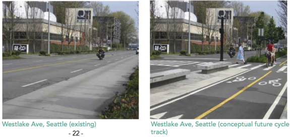
There is no clear and safe route for cycling on this flat and direct connection between the Fremont Bridge and South Lake Union/downtown. Even with the completion of the Dexter buffered bike lanes, many people choose to bike through the Westlake parking lot to avoid the significant climb on Dexter. Cascade Bicycle Club has been after a Westlake cycle track for years, and they even included a mock-up of what it could look like in their recent report card on Seattle’s bikeability:
When I first saw “Westlake Cycle Track” on the list, I immediately hoped it was a cycle track to address the still-very-dangerous SLU Streetcar tracks between SLU Park and downtown that continue to catch people on bikes off-guard and send them plummeting to the ground. While the proposed cycle track is also a great project, the SLU cycle track could fill one of the biggest and most dangerous gaps in the city’s bike network: Biking from SLU Park to downtown. Assuming it would be cost-prohibitive to dig up and move the SLU Streetcar tracks to the center lanes, it would also be a cost-effective way to solve the safety issue and provide a new connection. It could look something like this (note: I’m not a traffic engineer, so this shoddy photoshop job is just for imagination purposes):
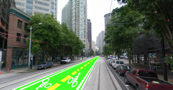 Or for an idea of how it would feel on a bike, here’s a similar design on Pennsylvania Ave in Washington DC:
Anyway, enough of my daydream. Here are more details on the recommended project, from the PSRC:
Location: Westlake Avenue North Description: Design and construct a 6,700 foot (1.3 mile) two-way bicycle-only path along Westlake Avenue North. The cycle track will form part of the Cheshiahud Lake Union Loop trail. It will provide cyclists with a physical separation from both motorized and pedestrian traffic sidewalk between the Ship Canal Trail and Fremont Bridge at its north terminus and downtown Seattle on the South terminus. Total Project Cost: $2,342,000
Changes to Renton section of the Lake Washington Loop
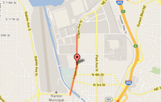 If you have ever ridden the Lake Washington Loop, a popular route both for commuting and for recreation, then you are perhaps familiar with the Logan Ave N segment, particularly the Cedar Rider bridge, where people on bikes mix with people walking on a skinny sidewalk.
One proposed project would extent the nice two-way trail across the bridge to meet with the Lake Washington Loop route. It would also implement complete streets work along the road all the way to the huge (seriously) shopping center, and would “replace” the existing bike lanes near the center. Not sure what the replacement bike facility would be, but that stretch could certainly be improved.
More details:
Title: Logan Ave N Roadway Improvements (N Airport Way to N 8th St) Sponsor: Renton Project ID: REN-29 Location: Logan Ave N Description: This project provides improvements between N Airport Way and N 8th St (4,200 feet), including urban roadway amenities to implement “Complete Streets”. Improvements also include transit signal priority system and the extension of the Lake Washington Trail on the west side of the Cedar River bridge. Other improvements include: reconstruction of the roadway pavement between the Cedar River Bridge and N 6th St. From the Cedar River Bridge to N 4th St the project will also add sidewalks, landscaped buffer, illumination. Between N 6th St and N 8th St the roadway will be widened to provide a Business Access and Transit (BAT) NB lane, replacement of the existing bike lane, sidewalks and landscaped buffer. Total Project Cost: $8,150,000
Mountlake Terrace Trail and Main Street Project
Two cool-sounding projects are up for consideration in Mountlake Terrace. One would be a trail connection between the Interurban Trail and the Mountlake Terrace Transit Center near I-5. Details:
Title: Lakeview Trail, Mountlake Terrace Transit Center to Interurban Trail Sponsor: Mountlake Terrace Project ID: MOU-19 Location: Lakeview Drive, Mountlake Terrace Transit Center to Interurban Trail Description: The project will construct a combination of bike lanes, sidewalks, and a new non-motorized trail from the Interurban Trail at 228th Street SW to the west end of the 236th Street SW bridge over Interstate 5, which is adjacent to Community Transit`s Mountlake Terrace Transit Center and Sound Transit`s Mountlake Terrace Freeway Station. The improvements will extend a distance of approximately one mile, of which about 0.8 mile will be a paved non-motorized trail, and the remainder will be bike lanes with adjacent sidewalks. Installation of bike lanes will be coordinated with the City`s Pavement Rehabilitation and Overlay Program. Total Project Cost: $3,106,280
The other is a Mountlake Terrace Main Street complete streets project that would rechannelize and add bike facilities to the neighborhood’s center. Details:
Location: 56th Ave W and 236th St SW Description: This project includes improvements to 56th Ave W (236th to 230th) and 236th St SW (Transit Center to 56th). It will reconstruct existing roadways to allow two travel lanes, bike lanes, and curbside parking. Other work includes: replace curb and gutter, construct sidewalks with tree wells, LED pedestrian and street lighting, upgrade storm drainage, upgrade curb ramps to current ADA guidelines, and modify/upgrade traffic signals including installation of optical fiber and connection to the City of Lynnwood`s Traffic Control Center. Total Project Cost: $8,436,488
I certainly left out some key projects in this list (see the Full list in this PDF), such as some interesting transit access projects (bike connections on Third Ave downtown?). If you have any thoughts or see any other projects that catch your eye, let us know in the comments.
Also, if you want to learn more about how the PSRC operates, their bicycle/pedestrian advisory committee meets at 1 p.m. Wednesday afternoon in the PSRC’s downtown conference room (1011 Western Avenue, 5th Floor). Here’s the agenda:







Comments
35 responses to “Regional Council recommends Westlake Cycle Track + more”
Wow, compared to the costs of the other projects, that Westlake Cycle Track is cheap-cheap-cheap and the number of users would probably crazy high. Get’er done PRC.
I’ll never understand why the city went all-in with Dexter when Westlake would be the obvious choice for the main north-south bike route in that section of the city.
I do think Westlake might be a place where I would use a two-way cycle track, as long as cars coming into and out of the parking lots were sufficiently controlled. I imagine it would be like a bike freeway of sorts, full of people speeding from one section of town to the other. There aren’t many destinations along that section of road.
SDOT staff told me that the bus and bike treatment Dexter received was effectively free in the context of the full rechannelization and resurfacing that happened there.
There are things between downtown and Fremont. Residences and businesses in Westlake. More are directly accessible from Dexter than Westlake or Aurora. That’s why we focus regular bus service on Dexter, and that’s one reason biking is important there.
I would put it next to the sidewalk in front of the businesses, essentially using the north-bound one-way lane where it exists. That way no conflict with vehicles entering/exiting the plenty-big-enough parking lot. And I would ignore the inevitable kvetching from the business owners and just build the thing. But yes, to be useful, it needs to go beyond SLU park!
I may be in the minority here, but I think spending over $2 million on a cycletrack on Westlake, when there’s already a neighboring route with reasonably good bike infrastructure, may not be the best way to allocate limited funds. I’d rather see the city tackle Eastlake / Fairview before spending more money on the west side of the lake. Sure, in the ideal world, let’s do both.
I wonder how much pushback the city will get from the businesses in the Westlake parking lot. I haven’t done a thorough study, but I don’t think many of those businesses are really catering to cyclists. It would be really unfortunate to see another missing link-style court battle.
Good point. Eastlake is a miserable, yet frequently used, cycling route.
The merge onto Harvard just south of the University Bridge needs some imaginative modifications as well. I wish there was a bike-only signal there to give cyclists a chance to merge before the on rushing traffic.
I agree.
I also dream of an Eastlake Esplanade, a floating biking/walking structure similar to Portland’s Eastbank Esplanade.
I imagine it could connect these two parks: https://www.google.com/maps/ms?msid=209027894998262833969.0004c9fee960a9c071eb1&msa=0
Just think of the stunning views of Gas Works and the way it would give people a chance to get closer to Lake Union. There could be gathering places, benches and, of course, a trail. If this were there, Fairview would obviously be the best way to get downtown from the U Bridge. It would also be the city’s coolest new park and close a gap in the Cheshiahud Loop Trail.
Love the esplanade idea. That’s probably the only way we’d ever get rid of that missing link (well, it’s not missing, it’s just like riding a roller-coaster in an alley).
I’ve thought of the Portage bay/U-Bridge area quite a bit. Here’s my idea:
* Center-street cycletrack on Eastlake from south side of Franklin Ave to the Harvard/Eastlake junction. Convert east bike lane on the U-Bridge to two-way cycletrack. Bikes get their own signal phase at Franklin/Eastlake.
* At the the Harvard/Eastlake junction, the cycletrack splits (continuing to be two-way):
** One leg goes up the west side of Harvard to Shelby St, where an existing signalized ped crossing gives access to the existing quiet bike route through Roanoke, or allows you to continue in bike lanes on Harvard.
** The other leg goes down the east side of Eastlake, probably east of the sidewalk (in the grassy area, avoiding a transit conflict at the bus stop there). The track ends at Allison St, which would get a new signal. That signal would have a bike only phase to allow people to get onto the Eastlake bike lanes or take Allison down to the Fairview greenway. The greenway could be resigned to come up Allison.
* Create a two-way cycletrack connecting the new east U-Bridge cycletrack (paralleling the road in the existing useless grassy embankment) to the existing 40th St cycletrack (there would be a crossing involved somewhere).
These cycletracks would have no property access conflicts and no transit conflicts; they could be fully separated using concrete curb sections, except for the Harvard/Allison intersection. A very small cars would have to U-turn at Allison to access a couple of properties just north of the Harvard/Eastlake intersection. The most expensive part would be the new signal at Allison/Eastlake and rewiring the signal at Franklin/Eastlake, followed by the new paving between the U-Bridge and 40th. The rest would be very cheap.
You lost me. I tried following your plan, but I’m not seeing where the center cycle track stuff fits in. I would probably need a visual.
However, I am very interested in this idea of making the east side of Eastlake/U Bridge a two-way cycle track. You could actually continue that all the way to Shelby to avoid the need to make that awkward/dangerous uphill merge to the bike left turn lane when headed to the Roanoke bike route. And if they move the nb bus stop to the south side of Shelby, they could avoid that transit conflict easily and w/o an island (the only transit conflict for this cycle track, which is pretty crazy, actually).
Then, to get southbound folks in the bike lane on the west side of the U-Bridge to the new two-way cycle track and up Harvard, you could install a bike signal phase and bike boxes Fuhrman/Fairview and Eastlake. If you cross the bridge and arrive to a red light at Fuhrman, get in the bike box and make your left turn into the cycle track during the bike signal phase. If you arrive on a green, get into the bike box on Fuhrman and wait for the regular furman signal, then cross and turn right into the cycle track. You could also do the same for people headed northbound in the cycle track to get to Fuhrman/Fairview and head south through Eastlake using the same bike signal phase. Or maybe this bike phase could even go at the same time as the left turn phase for southbound general traffic (since we are getting rid of the nb left turn phase that is largely unused). That might not even have a huge effect on traffic signal timing, though it might be unusual. These are details for an engineer to figure out, of course.
Here’s that cycle track on a map (use satelite view, but turn off 45 degree view)
It’s also important to remember that there is a lot of room to work with on Eastlake on the south side of Fuhrman the bridge b/c the left turn lane to Fuhrman/Fairview is not needed (have you ever seen somebody use it?)
Second, are you talking about the embankment under the I-5 Bridge? I assume WSDOT owns that land, right? There should be some kind of bike box/bike crossing to Harvard here:
I am intrigued by the idea that we could maybe put a trail between the sidewalk and that parking lot (or through the parking lot, if need be). I’ll have to go spend some time there in person to get a better look, since I’ve never really given that much thought.
One hurdle I see to these ideas: Is the U-Bridge bike lane wide enough for two-way bike traffic (usually ten feet is the minimum standard)?
As an Eastlake commuter, my favorite daydreams involve (1) bus islands and/or (2) a giant laser that instantly vaporizes anyone who stops in the no-stop zone during commute hours. An esplanade would probably make me less hostile.
For a zero-cost improvement on Eastlake though you could just extend the no-parking hours. At 5pm the ride home is okay, because you have the right lane as a de facto bike lane. At 6pm it’s murder, as traffic in the left lane is still quite heavy and there’s a solid wall of shenanigans to the right as the lane converts from a travel lane to street parking. By 7, traffic has usually died down enough to be okay again even with the parking.
I’ll add one more idea to the mix, which I think complements your ideas of an Eastlake cycletrack nicely: For riding between U Bridge and Harvard/Roanoke, a pleasant alternative is the Fuhlman-Franklin shortcut to totally bypass the nasty Eastlake & Harvard intersection.
i respectfully disagree, matthew. a cycle track between fremont and downtown would be *transformative* in regard to cycling in seattle. most normal folks who live and ride north of the ship canal would finally be able to ride downtown without going over a hill. i don’t think we can underestimate the impact this fact alone will have on the 90% of run-of-the-mill cyclists (and drivers or bus commuters that might hop on a bike) that live north. for years, i’ve felt the most most maddening part of seattle bicycle infrastructure is that the only sanctioned north-south route from north of the ship canal to downtown is over dexter. a fucking hill.
cycle-track westlake, and it’ll change the city. mark my words.
A cycletrack on Westlake will not change the city.
1. The hill on Dexter is really not that much. The vast majority of the population north of the ship canal lives up much tougher climbs from the ship canal than the hill on Dexter. If the hill on Dexter is too much for 90% of Seattle then 90% of Seattle will never bike anywhere.
2. Similarly, in terms of bike facilities, for most people that would use Dexter today, Dexter isn’t the worst part of their commute (until you get down almost to Denny).
3. A cycletrack on Westlake only changes the city for people that live along Westlake, or north of the ship canal and west of maybe Wallingford Ave. That’s a pretty small portion of the city, and most of the rest has much worse biking conditions than Dexter.
4. A cycletrack that ends at SLU Park doesn’t get people into downtown — nor, indeed, into the parts of SLU they need to go to do practical things on their bikes. The one cycletracks that could truly change the city would be ones through downtown. Home to some of Seattle’s worst cycling conditions, and where the potential for cycling is greatest.
I have to agree with eric about Dexter being a hill preventing people from even trying it. I’m one of those people, and can’t see myself trying Dexter until I’m in much better shape. I actually enjoy doing the parking lot ride along Westlake (both directions) between the Fremont Bridge and SLU Park — it’s plenty safe enough and fast enough for me as-is, so I wouldn’t prioritize putting in a cycletrack there (Eastlake is another story!). (For background, I live in Ballard, and normally ride the BG zone from Golden Gardens to U Village, crossing the Ballard, Fremont or Univ. bridges and heading downtown via Interbay, Westlake or (rarely) Eastlake.
Al’s right about the key strech for cycletrack being south of SLU Park; getting there is easy, it’s going into the downtown zone that’s tricky.
[…] is the original post: Regional Council recommends Westlake Cycle … – Seattle Bike Blog This entry was posted in Blog Search and tagged car, centric, cheshiahud, huge, marked, missed, […]
Westlake is scary as hell but gets you downtown really fast. Pedal hard because your life depends on it.
I ride it once in a while but only if the light is already green and I can carry good speed through the intersection coming off the bridge.
“One hurdle I see to these ideas: Is the U-Bridge bike lane wide enough for two-way bike traffic (usually ten feet is the minimum standard)?”
It’s usually a tight fit for faster riders passing the slower ones on the University Bridge from what I’ve seen, but I haven’t put a measuring tape to it. The high ledge by the walkway probably causes some bicyclists to steer a bit further out than they normally would.
The walkways are also somewhat cramped, especially around the parking bulges. Probably very expensive to raze the ledge and associated lighting to carve out a wider bicycle/pedestrian way, as I’m not sure what’s in the ledges (just filler material? critical electrical wiring?).
Westlake cycletrack = another idea for a bike path paralleling an existing adequate route that stops just far enough from downtown to be useless.
Forget this part of Westlake, forget 520, forget the godawfully terrible ideas people seem to come up with to get the Mountains to Sound Trail to the sound. The route that needs to be connected, the route that will really transform Seattle, goes from around Dexter and Mercer to the unceremonious northern end of the SODO trail. After that, connections to and along the waterfront. After that, creating at least one non-awful north-south route and one non-awful east-west route through SODO. I mean, do 520 because we have a unique opportunity, like we did with Dexter. Other than that, we shouldn’t be planning more bike routes elsewhere until we fix downtown and SODO.
Good points, Al.
I agree with others (and former Mayor Nickels) that a Westlake complete street is a no-brainer and should have been done long ago. Controlling cars entering and exiting the parking lot is liable to be difficult and I’d prefer a cycletrack between the parking lot and the businesses for that reason.
Westlake is a beautiful placed for improved infrastructure not only for its relative flatness, but because it has a nice anchor at South Lake Union Park and then continues on to Westlake Ave through SLU, which in my 5 years of biking through the neighborhood is still my preferred way to get downtown from north of the Ship Canal.
Functionally, I think a good cycle track in the Westlake corridor (possibly coupled with some sort of infrastructure improvements on the part of Westlake where the streetcar runs) would allow a low-stress, safe feeling, and easy ride for bike share riders all the way from 5th Ave to Fremont. This really does seem huge to me.
Any expensive bicycle infrastructure project needs to be viewed in a larger context. What I’m sure we all want is this: a network of routes throughout Seattle that can support riders of all abilities. This means you could ride from, say, Fremont to Capitol Hill on a *continuous* path, where there are zero sketchy roads or intersections and the grade is as low as physically possible. This is exactly what the Bicycle Master Plan ought to outline.
Once we have a network outlined, we need to determine what the are expensive parts (cycle tracks) and what are the cheaper parts (greenways), then prioritize them in a way that considers 1) cost and 2) how much any given piece of infrastructure connects the larger network.
I think that given that framework, we would most likely de-prioritize a Westlake cycle track given the fact that Dexter exists.
Cycle tracks don’t NEED to be mega expensive. On roads without transit, parking-separated cycle tracks are really just paint and signage. Where things get really pricey is when transit uses the same street and you need bus islands or where you need to create bike signals and other traffic light changes or if you want to couple the cycle track with a nice planted median or concrete divider.
Cycle tracks are really cheap as transportation infrastructure goes. But our planning energy is finite. Why is the PSRC planning a redundant facility on Westlake (with far fewer intermediate destinations between Fremont and SLU) and not looking at all at going through downtown, the place that needs the most attention.
There are two possibilities (not mutually exclusive). First, that the PSRC doesn’t actually care about cycling aside from looking good at ribbon-cutting ceremonies. Second, that the PSRC doesn’t actually want downtown cycling to succeed. Either way, their priorities need serious adjustments.
Anyway, transit doesn’t have to complicate the situation for parking-separated bike lanes or cycletracks. Buses can stop in the lane, and paint (maybe cheap-ass metal barriers if we want to be fancy) can mark off breaks in the parking for bus stops. In Seattle we insist on gold-plating every project; if we did it cheap we could do it everywhere fast, and probably with lower ongoing maintenance costs, too.
What does complicate parking-separated cycle tracks is turning and cross-street issues at uncontrolled intersections. In some places (Westlake) this doesn’t matter as much, but in others (Roosevelt to a very large degree and Dexter to a lesser degree) it matters a lot and pretty much makes the whole idea ridiculous.
I’ve only bicycled on Westlake or the maze of sidewalks thereabouts. Even after knowing that there are apparently bicycle facilities up on Dexter, I would still only bicycle in the Westlake mess. Is there something compelling (coffee shop? a car free experience?) up on Dexter worth the climb?
I, along with many other people, work in what I would call the Denny Triangle area. Dexter, as nice as it is, just doesn’t work as well as Westlake to get to work, even considering you are riding in a parking lot most of the way.
Consider both Westlake and Denny once you hit Mercer Street. From Westlake, it’s an easy jog over to 9th Ave just before Mercer St, which has nice bike lanes and minimal conflicting lights, which tend to stay green for a long time, not to mention a light to cross Denny! From there, you have your choice of 9th or 7th to get across Westlake.
Compare to Dexter, south of Mercer and you can see why a lot of people turn their nose at Dexter while continuing on Westlake past the Fremont bridge. If they do end up building this cycle track, I hope they make the transition to 9th Ave a little more seamless.
[…] the new pieces we noticed is that the budget includes Federal funds for the Westlake Cycle Track we wrote about previously, suggesting that there is some real momentum behind that […]
[…] the planned Westlake cycle track from the Fremont Bridge to South Lake Union Park, which was recently recommended for funding. Once completed, “we anticipate the numbers will increase very rapidly,” said […]
[…] neighborhood greenways. Also specifically mentioned: A cycle track to connect the already-funded Westlake cycle track to the mostly-Amazon-funded 7th Ave cycle track. From the […]
[…] this. Similar attention is needed for the crucial four-block connection between the forthcoming Westlake and Mercer underpass cycletracks, which will be the bike gateway to Uptown and the Seattle […]
[…] Lake Union is still super dangerous for cycling due to the streetcar tracks in the curb lane? Well we have argued that the city should design protected bike lanes in the center lanes of the road, like on […]
[…] regionally – but this project is a high priority of the Puget Sound Regional Council, even receiving funding from them last year. For him to oppose this project (or, you know, “let’s do another study” when […]
[…] reads the campaign email. Despite some very clear factual errors (the project was actually selected for funding by the Puget Sound Regional Council and has been pushed hard by the City Council in addition to Mayor McGinn), the email raised some […]
[…] Backed by grant funding, the project is entering the early design phase, and they need your input on what you’d like to see. […]