
SDOT has released updated design work for the Beacon Hill bike lane project, which includes two options for 15th Ave S as well as different options for handling bus stops.
As Ryan Packer reported for the Urbanist last month, the project team has also confirmed that construction is now scheduled to begin in spring 2024, a year later than initially scheduled. The project timeline calls for another five months of planning followed by about nine months of design. Since it is usually best to avoid construction during rainy winter months, that puts the start of construction at spring 2024.
Many safe streets advocates, including Seattle Bike Blog, expressed frustration with this delay. We wrote that Mayor Bruce Harrell and SDOT Director Greg Spotts should “push the department to treat the project with the urgency it deserves.” The latest update from SDOT seems to acknowledge these frustrations, saying, “Our project timeline recently shifted to being in construction later than planned. We’re looking at ways to reduce the overall timeline and get these improvements implemented sooner.”
Regardless of how the project got delayed, the team has clearly been working through the design. This is not a simple project. They spent much of the early community planning work looking at route options between the Jose Rizal Bridge and Beacon Ave S before settling on 15th Ave S. Since then, they have developed two major alternatives for 15th: One-way bike lanes on each side of the street or a two-way bike lane on the east side of the street. Both options would be separated from general traffic lanes using concrete barriers. You can see an overview of the options below or look at the full map in these PDFs: Alternative 1 and Alternative 2.
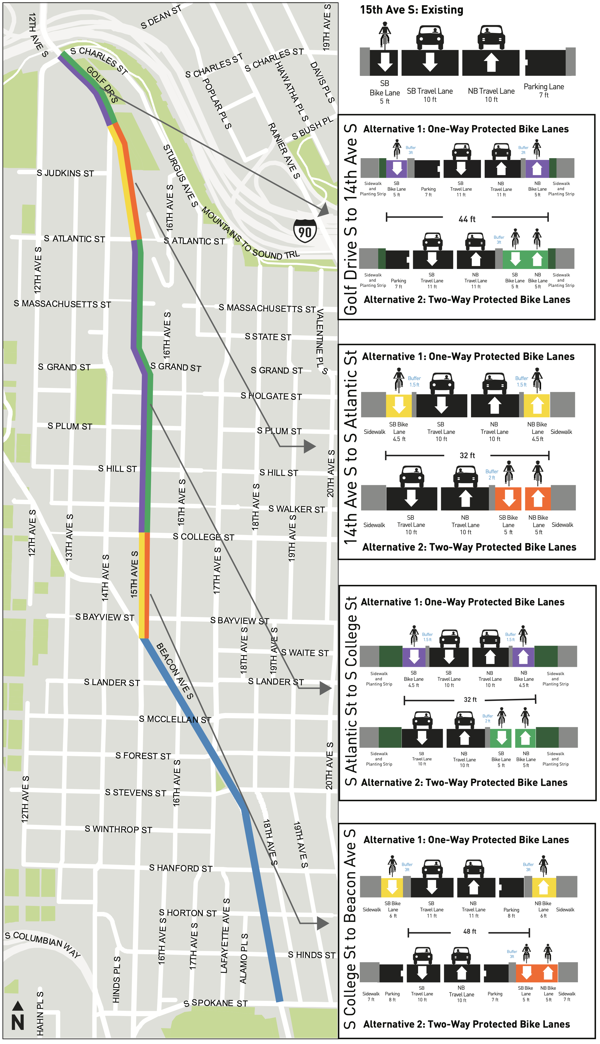 Neither option preserves on-street car parking because the roadway is simply not wide enough to have bike lanes, two general traffic lanes and parking. One-way bike lanes are usually preferable to two-way bike lanes on two-way streets unless there are special circumstances. For example, if a road is next to a hillside, waterway or park, then a two-way bike lane might make a lot of sense because there would be limited traffic crossings and driveways. Another example would be a road where the connections to existing trails or bike lanes would be easier and safer with a two-way lane. A two-way lane might also sometimes be a necessary compromise if there simply is not enough roadway to accommodate two one-way lanes. However, none of these seem to be the case on 15th, at least not at first glance.
These sorts of decisions put Seattle Bike Blog and advocates in a tricky spot because ideally SDOT would not seek public input on design decisions like these. Instead, they should determine through their expertise which option is the safest and best-connected design and go with that one. In this case, that is likely the one-way bike lanes option (though I am not a traffic engineer and haven’t studied every foot of roadway). However, safe streets advocates know all too well that they must keep constant pressure on SDOT to pursue the safest options because such decisions are not a given, and this is a dynamic I hope changes within the department.
Zooming in on a few key spots helps highlight the benefits of the one-way lanes, especially in terms of usability. For example, the biggest issue with the two-way lanes would be the transition points. People heading up Beacon Hill from the Jose Rizal Bridge, likely one of the most popular travel paths, would need to wait awkwardly and cross in the crosswalk near the south end of the bridge. But the trade-off is that people heading up the hill from the Mountains to Sound Trail (top left corner of the intersection as pictured) would have a slightly more direct connection:
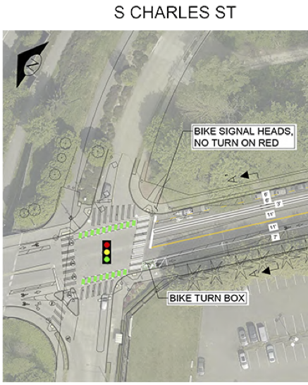 The other major complication is the intersection with Beacon Ave, though neither alternative has a quality design as currently planned. The barrier protecting the one-way bike lanes would shrink to a bare minimum to make room for a left turn lane. The southbound bike lane would also lose priority for making a left turn, with users directed to use a left turn box and wait for the signal to change again.
![]() The two-way bike lane would be protected up to the intersection, and then people walking and biking would get an all-way signal phase to make their crossings.
The two-way bike lane would be protected up to the intersection, and then people walking and biking would get an all-way signal phase to make their crossings.
![]() This is a tricky and strange intersection, but I would love to see some creative options that pull from protected intersection designs to help make the bike left turns more streamlined and to slow down the obtuse right turns from Beacon to 15th.
This is a tricky and strange intersection, but I would love to see some creative options that pull from protected intersection designs to help make the bike left turns more streamlined and to slow down the obtuse right turns from Beacon to 15th.
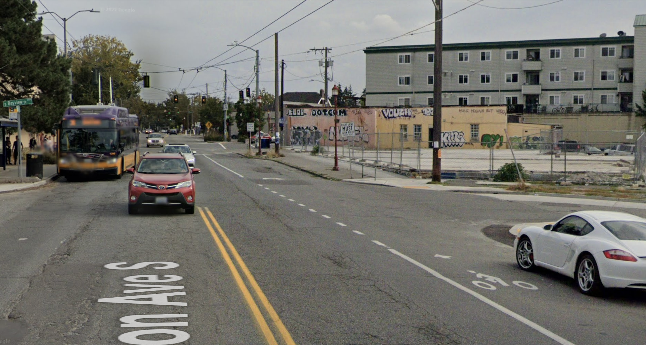
It also seems like a major oversight that the current design does not connect the existing (albeit outdated) southeast-bound bike lane on Beacon Ave to this intersection. That bike lane currently ends about a half block away at Bayview:
To make this work, the team may need to expand the scope of the project to include the half block of Beacon Ave to the west of 15th, but such an addition would make the project stronger and would better connect to the existing bike network. It would also make use of the additional planning and design time.
Or better yet, the project could expand to include the full block of Beacon Ave between 14th and 15th Avenues. 14th has bike lanes and is also the site of a great safety project from 2014. It is also the start of a path leading to the Mountains to Sound Trail and the Holgate crossing of I-5. If we’re going to delay the project, then let’s do it right rather than leave behind a one-block missing link.
The section of Beacon Ave that is already part of the project only has one alternative: One way bike lanes on each side of the street. There are different options for how to handle bus stops, but the bulk of the design seems mostly settled. In general, the center turn lane disappears to make space for the bike lanes. This segment alone will make an enormous difference for bikeability in the neighborhood. This stretch of road also has a terrible history of collisions injuring or killing people in the crosswalks, especially near the light rail station and library. Making improvements to those crosswalks will hopefully save lives.
![]()


Comments
6 responses to “A look at latest Beacon Hill bike lane designs + SDOT says they will try to build them ‘sooner’”
So the BIG decision is two one-way lanes or one two-way lane? And we’re going to lose a year of construction time asking people to weigh in on a decision that should be left to the engineers.
SDOT please, just decide and build it already. Phase 1 won’t start construction until 2024. Every month you waste project costs go up which means levy dollars don’t go as far and less overall bike infrastructure gets built in the city. Part of putting safety first is finishing safety projects in a timely fashion.
The section from 14th to the Rizal bridge (the big hill next to Pac Med) seems particularly bad for a two way lane. Uphill riders are grinding at 5mph while downhill are riding the brakes to keep it under 20. Although I do wish they’d do more to T off or reconfigure the slip lane into 14th southbound, but I can see how that gets pricey fast with the trolley wire.
Glad to see these plans, and SDOT on damage control after unceremoniously delaying this timeline. For what it’s worth, rumor has it that the “Beacon Hill Council” (whatever that means) is actively working to cancel this project entirely, going as far as pointing to the 35th Ave NE debacle as a model to replicate. So keep on the advocacy and keep emailing SDOT and the Mayor’s Office to make sure they know that a few grumpy parkers don’t have veto power over four years of planning and provisos.
Option 1 and build it already. SDOT has screwed up design on all their other bike projects (only safe way down Fauntleroy is in the traffic lane). They have never taken extra effort to get good planning and design right yet.
Two one-way PBL seem much better; an issue not mentioned by SBB is the transitions at the end of facility. Note the southern part would run coincident with Route 36; SDOT will have to be careful; bikes may be asked to yield to bus riders boarding and alighting at the humps.
I wanted to post this to begin an effort to gain community support, Thanks
To make this a wider connection the extension of the Mountain to Sound trail to Forest Street with access to Beacon Ave would do a lot to offer alternatives in various directions. This would connect to the light rail line, the SODO trail to downtown and an improved access to West Seattle and Alki. It would also discourage camping in the greenbelt with positive activities.