
2020 was a year of adjusting to new realities, and Seattle’s effort to meet its goals for expanding its bike network did not escape the curveballs that were thrown during the year. In response to a fundamental reshuffling of demand for right-of-way compared to other years, the Seattle Department of Transportation responded with a few new programs, namely Stay Healthy Streets, but mostly stayed the course even as Covid impacts on staffing delayed projects and Covid-induced budget cuts imperiled future ones. 4th Avenue finally has a protected bike lane, protected lanes on Bell Street were installed, and bike lanes on Avalon Way in West Seattle opened just as the West Seattle Bridge was closed in March.
Now that 2021 is here, we are looking forward to some of the projects that are planned for the year across the city that will improve conditions for people biking.
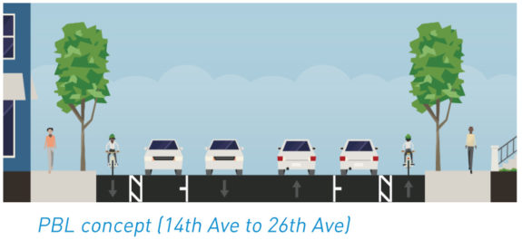
Construction has already started on the installation of this bike lane, which won’t extend north of King Street due to concerns about impacts on traffic, namely the First Hill Streetcar, which doesn’t operate in its own dedicated lane.
12th Ave will feature similar to bus stops to the ones that were installed along NE 65th Street, with bus riders exiting directly into the bike lane. The PBL will extend all the way across the bridge to the connection with the Mountains to Sound trail. A route running the entire length of Beacon Hill is currently planned for 2023.
Asphalt surfacing installed https://t.co/1iTXwikzJD pic.twitter.com/glPX8MVi6U
— Dongho Chang (@dongho_chang) December 19, 2020
This project was originally planed for 2020 but was delayed due to coordination with Metro on moving trolley wires. A big win for advocates, this bike lane was originally planned to disappear on either side of the busy intersection at 23rd Avenue but was redesigned earlier this year to bridge the gap. Though the protected bike lanes will not extend west of 14th Ave, the Madison RapidRide project, which SDOT says will start construction next year and take about 3 years, will connect the facility across 12th Ave.
Another 2020 holdover, this project will finally connect the Burke-Gilman at Stone Way with the Fremont bridge instead of that harrowing door zone lane. The project will also add a northbound protected bike lane just north of the bridge, making the transition from the cramped bridge deck a little more seamless.

The first phase of the long-awaited Melrose Promenade project will get underway next year, with protected bike lanes getting installed on Melrose Ave E in far west Capitol Hill between Pine Street and Denny Way. Between Pike and Pine, one of the most obvious places in the city to turn into a pedestrian street, people on bikes will share the road with cars and a massive raised intersection will be installed in front of the Starbucks Roastery. North of Denny Way, SDOT will be installing speed humps in the style of a greenway.

The repaving project for the east half of the street circling Green Lake will finally be wrapping up next year, including protected bike facilities from Aurora and 83rd all the way to N 50th Street. A separate project will install protected bike lanes on a segment of Stone Way south of N 50th Street as well. The paint bike lanes on 50th Street are staying in place.
With these bike lanes the North Seattle bike network will really start to fill in, with Ravenna Boulevard and NE 65th Street fully connected to north Wallingford.
The Durkan administration’s decision to eliminate bike lanes on N 40th Street that would have been installed while that street was being repaved is still disappointing.

Northgate Pedestrian & Bike Bridge
With the grand opening of the Northgate Link light rail extension in the fall, the bike and pedestrian bridge over I-5 will also be ready for traffic. This will open up a brand new connection at N 100th Street between the light rail station and North Seattle Community College.

On the Northgate side of the bridge, separate bike facilities will connect NE 92nd Street all the way up to Northgate Way along 1st Ave NE.

The bicycle improvements required as part of the agreement to renovate Key Arena into what will be Climate Pledge Arena are set to be installed by fall’s opening of the facility. The route will take several zigs and zags as riders heading to Uptown will take Broad Street onto 1st Avenue, continue onto 1st Ave N, and then have to take Thomas Street to Queen Anne Ave to continue north to Mercer.

SDOT will come back and improve the 4th Avenue protected bike lane they installed in 2020 by extending the lane north to Vine Street, converting the entire corridor to a two-way facility, and extending it south to Yesler Way via the out-of-the-way Dilling Way. SDOT says they envision the lane eventually connecting south to Main Street but not until there are fewer buses using 4th Ave S.

As part of a project to make more space for Metro buses to lay over in South Lake Union, SDOT will be reconfiguring Eastlake Ave E along I-5 south of the Lakeview overpass and adding protected bike lanes, although a short segment between Mercer and Roy Street will be a multiuse trail. An extension north to the bike lanes planned as part of the RapidRide J line will be coming later.

All of these projects are set to happen while a wide-open Mayor’s race takes place where transportation issues like the West Seattle bridge take center stage, and the two at-large councilmembers (two of the best on transportation) are also up for reelection. The only thing that’s certain is uncertainty.


Comments
6 responses to “What 2021 means for Seattle’s bike network”
Depressingly little action south of downtown.
I was just thinking the same. The one coming infrastructure improvement just barely qualifies geographically on the very north edge of Beacon Hill / Jose P. Rizal Bridge / 12th Ave. No action or discussion on bike infrastructure in all of SE Seattle, SODO / Georgetown, West Seattle? Zero, zip, nada?
The one bright spot of the pandemic in SE Seattle for bicyclists was the temporary opening during part of the summer of Lake Washington Blvd between Seward Park and Mt. Baker park to walking and rolling users. That was badly botched in the beginning by a lack of enforcement and physical protection (barriers diverted to protect SPD stations from outraged citizens). Since that protected walking and bike facility ended with summer, SDOT has on two occasions briefly and temporarily re-opened a short, 1 mile segment between Mt. Baker Park, and just north of the Stan Sayres park and boat launch.
That’s about it. No permanent infrastructure improvements or changes coming to my quarter of the city. Nothing of note to look forward to coming to the entire south end, other than possibly a study of a possible routes on the crest of Beacon Hill and MLK Jr. Way S. that may or may not ever actually happen some years from now.
I would love to see Lake Washington Blvd taken back permanently from speeding commuters and racers and utilized fully to it’s best purpose — a stunning promenade for the citizens of this city to enjoy at a sedate pace. SE Seattle desperately needs a safe, protected, and efficient north – south connection put into place to link SE Seattle to downtown, ideally utilizing the flattest and best option (Rainier Ave S.). But I might as well wish for a pony and a bag of gum drops while I’m at it.
It remains inexcusable that the south end wasn’t prioritized more with direct connections by the levy. But the city does say they have full funding for the MLK bike lane between Judkins Park and Mount Baker, the bike lane running the entirety of Beacon Hill (both planned for 2023) and the Georgetown to South Park trail. There are also bike lanes coming with Delridge Rapidride in 2022.
Thanks for the stream of great articles in the last two weeks Ryan, these have been great reading and super informative!
We need to keep pushing SDOT to come up with a creative way for safe passage of cyclists in the gap between Yesler and King. I understand it is a very space constrained section, and the local businesses are worried about impacts, and Metro is probably worried about delays to buses, and SDOT worried about the streetcar, but do we have to wait for a cyclist to die before we do something about it?
Also, please repave the intersection of 12th and Boren. It is an archipelago of pavement amidst a sea of potholes. I’m pretty sure there are bricks somewhere under there.
The 12th Avenue South issues go beyond the streetcar. The intersection is a transfer point for routes 7, 9, 14, 36, and 60. ROW is scarce. The East Union project was under funded; SDOT was imposing capital costs on another agency. At 23rd Avenue, routes 2 and 48 have a transfer point. On North and NE 40th Street, bus stops serve routes 26, 31, and 32; the SDOT plan did not seem to accommodate them. NSC dropped “community” from their name. The 1st Avenue NE cycle track will have a southbound bus stop at NE 95th Street (hump). When SDOT reconfigures Beacon Avenue South, they should also improve the flow of Route 36; there seems too much ROW devoted to car storage. Here’s hoping SDOT provides bikes priority on Pike Street and bus transit priority on Pine Street. A similar specialization could have been used in Uptown, but was not. At least the 1st Avenue North bike lane is on the left side of 1st Avenue North. Note success on Ravenna Boulevard: left side for bikes; right side for transit. Speaking of Eastlake Avenue East and the J Line, I wonder about the bus humps there with higher bike volumes and speeds along with with more bus riders; will all play nice?