
Every region of Washington State could someday have nationally-signed and connected bicycle routes optimized for bicycle travel and transportation.
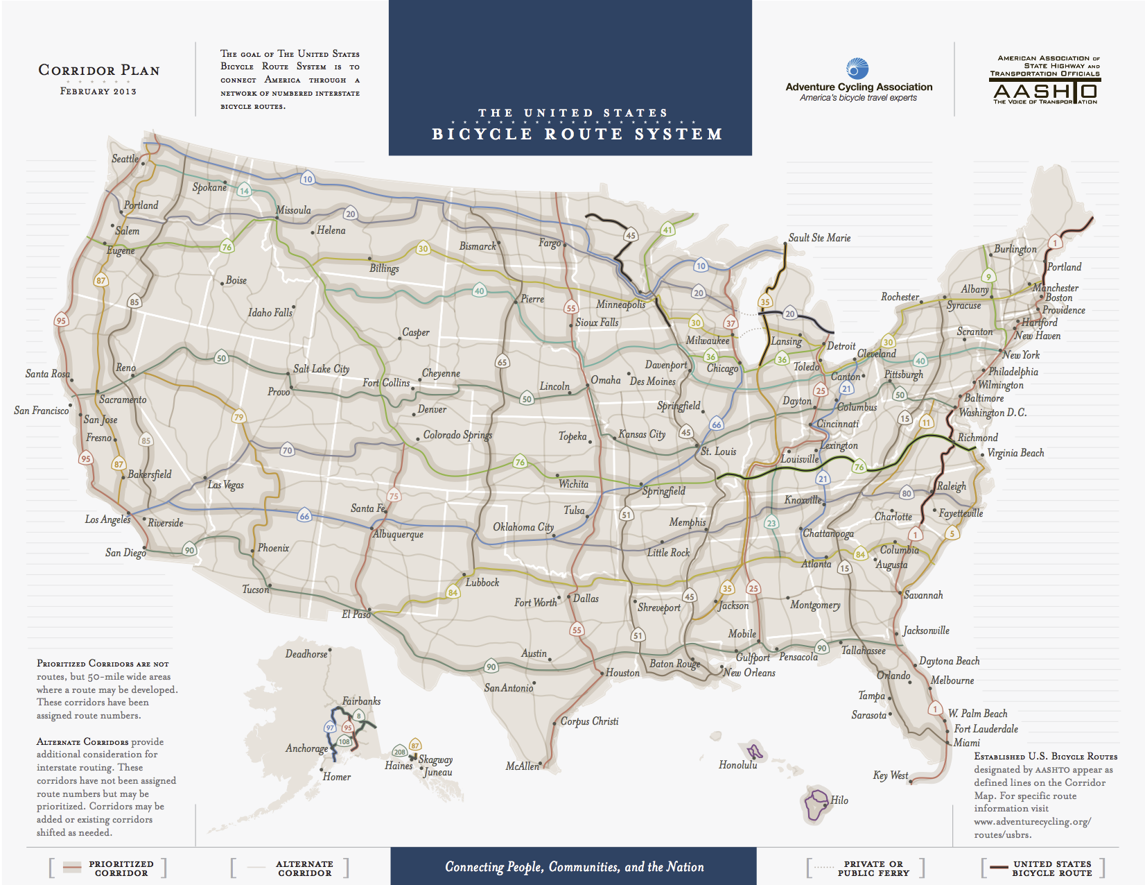
The US Bicycle Route System is a vision for a network of these routes, allowing for easier and safer bicycle travel to all reaches of the nation. The country already has some active segments in the Mid-West and East Coast.
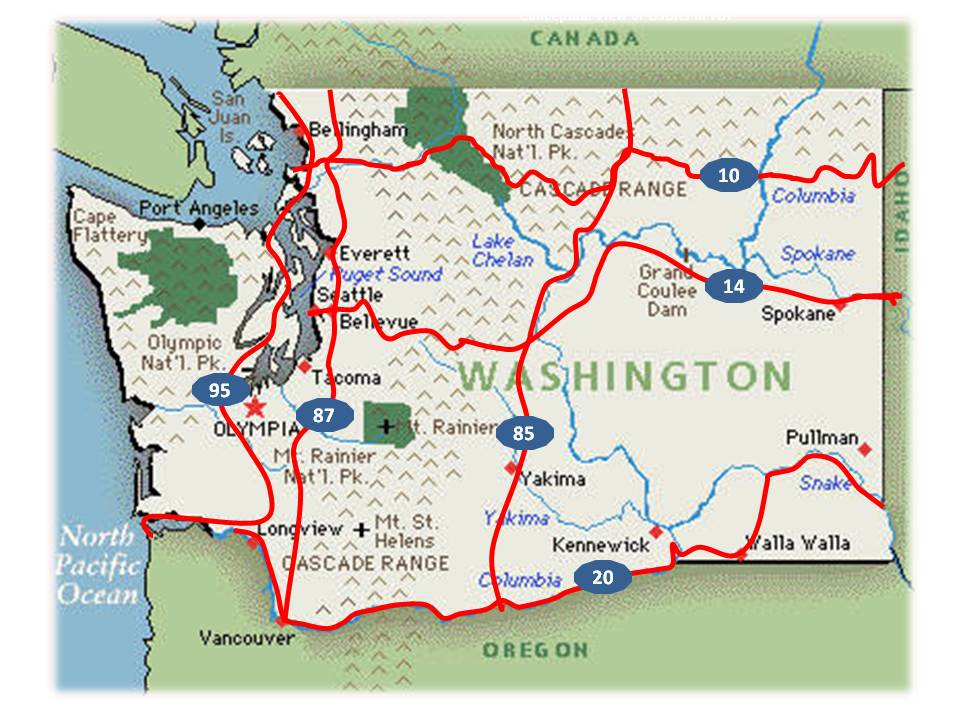
Washington is working to develop USBR 10, working with towns, cities and parks across northern Washington. And, as the Bicycle Alliance of Washington’s John Pope reports, the collaboration has already resulted in some unexpected benefits.
The USBRS process involves working with jurisdictions and cyclists along a conceptual route corridor, selecting destination towns and finding the most bike-friendly combination of roads. Once the nominated route is complete, it is reviewed once again by the jurisdictions (towns, counties and WSDOT regions). The draft nomination then needs approval from the top transportation directors of the affected adjacent state, our state and finally the AASHTO USBRS numbering committee.
Sounds daunting, but any journey of a thousand miles begins with a single step. Our first steps went well. Over the winter we worked on the nominated route from the Anacortes Ferry Terminal to Rainy Pass in the North Cascades. Anacortes, the Swinomish Nation, Burlington, Sedro Woolley, Hamilton, Concrete and Skagit County jurisdictions, along with three major cycling advocacy groups (Skagit Bicycle Club, Active Communities Taskforce and Anacortes Bikes and Walks) all have filed resolutions of support, endorsing the nominated route.
Great design review sessions with city staff and county staff have created alignment and added unexpected improvements. Planned revisions to a city park added camping for bike tourists and aligned shoulder revisions when they saw the draft USBR. Experienced input from local cyclists and ACA influenced the route significantly. Regional traffic planners were able to gather traffic loads, shoulder widths and road surfaces to help determine best route choices. It takes input from all sources and the USBRS standards to come up with a harmonized route nomination!
The USBR dream:


Comments
4 responses to “BikeWA: Work progressing on state’s first official US Bike Route”
Could, pray tell, we see state and maybe even county routes as well?
For as long as I could remember I imagined sidewalks, trails, and other walkways as streets and roads for pedestrians, which grew into a whole shadow world where each jurisdiction was one level higher than it actually was – Seattle County in the state of King in the nation of Washington – with neighborhoods taking the form of cities. (Here’s the map of neighborhood boundaries I use, with downtown ending at 9th and Virginia and the Denny Triangle northeast of there – all developed with sidewalk continuity in mind where possible.) My interest in non-recreational bicycling actually started when the Roosevelt Way bike lane was painted right near my house along with other BMP work; I actually followed the crews doing some of the painting from near my house to where it peters out near 41st, which got me thinking of how bike lanes fit into the plan, and I eventually came to the conclusion that they were analogous to freeways (obviously a flawed analogy). That along with other things led me on a binge of applying route numbers to trails and bike routes across the city; I actually gave the I-90 trail the route number 10 (because former US route number and all that), with the Burke-Gilman being route 6 and the 520 trail being route 8 (I could run down all the route numbers I have if you like), though I can understand why they went with the routes 10 and 14 they did.
I’m glad that someone is doing this mapping. As a person who rode across the country without such a map it would have been handy to know where the bike friendly roads were. It wasn’t terrible just using my intuition and good state map, and some states even published a bicycle map where the freeways are labeled less prominently than side roads. Missouri I think was the state. But having things interconnected, knowing where the hostels, parks for camping, bicycle stores etc were would have been nice.
Gary,
You should check the maps produced by Adventure Cycling. They have a series of maps that cover East-West travel and North-South routes. Their maps are color, high-quality plastic based and they list the various services available. I used these maps over 10 years ago when I rode a portion of the Great Divide Mountain Bike Route (GDMBR) from the Canadian border to Butte, MT.
Other than a 4-day round-trip from Woodinville to Winthrop a few years ago, I haven’t had an opportunity for a long-distance bike trip.
http://www.adventurecycling.org/
Second MikeG’s comment. I’ve ridden that proposed bike route 10 from Discovery Bay on the Olympic Peninsula to Newport Idaho, on and parallel to US highway 20, following the Adventure Cycles route (backwards). It is a great route though all kinds of Washington state environments and towns. The section just west of Burlington needs the most help to make it friendly.