
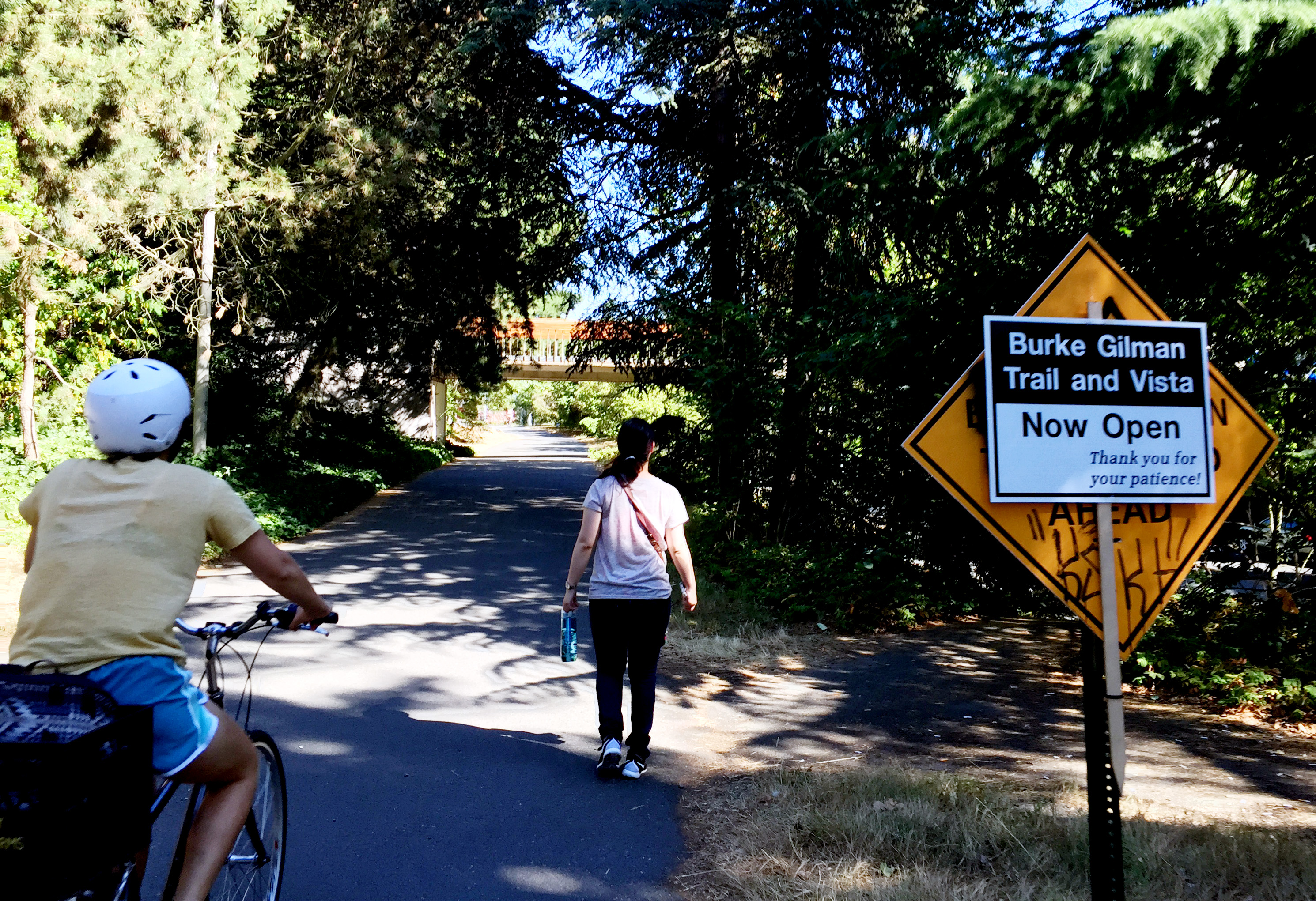
After a year and a half of ever-changing detours, one of the busiest sections of trail anywhere in the State of Washington (and maybe the entire country) reopened Wednesday afternoon.
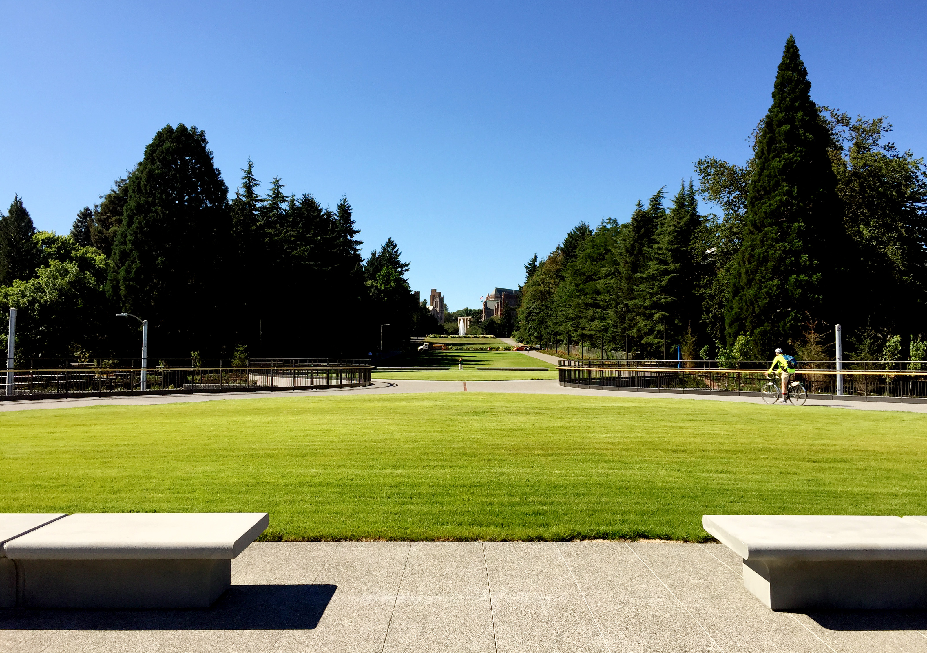
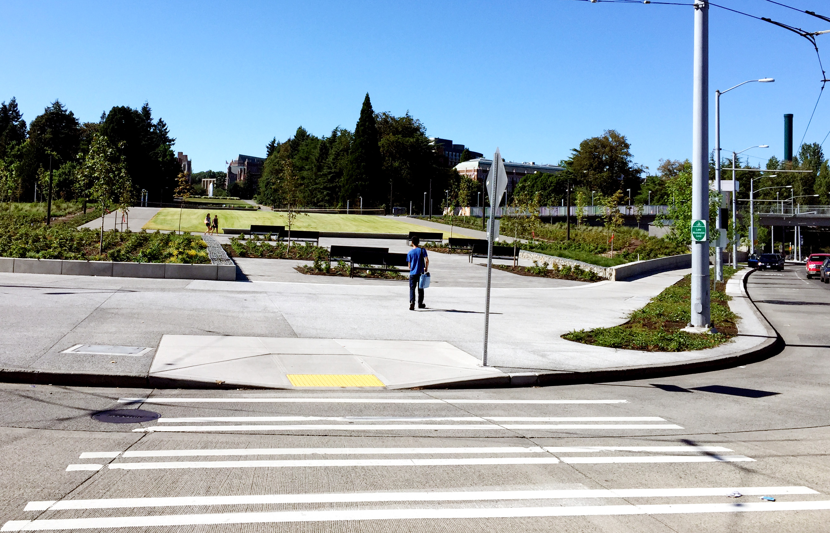
The completely redesigned “Rainier Vista” area has a much grander, people-focused feel with wide pathways, sprawling lawns and park benches. It is very easy to imagine people hanging out here in big numbers, especially when UW classes are in session. Much like Cal Anderson Park on Capitol Hill, it’s a simple, comfortable place to just enjoy being in Seattle.
And true to its name, it has a spectacular view of Mount Rainier.
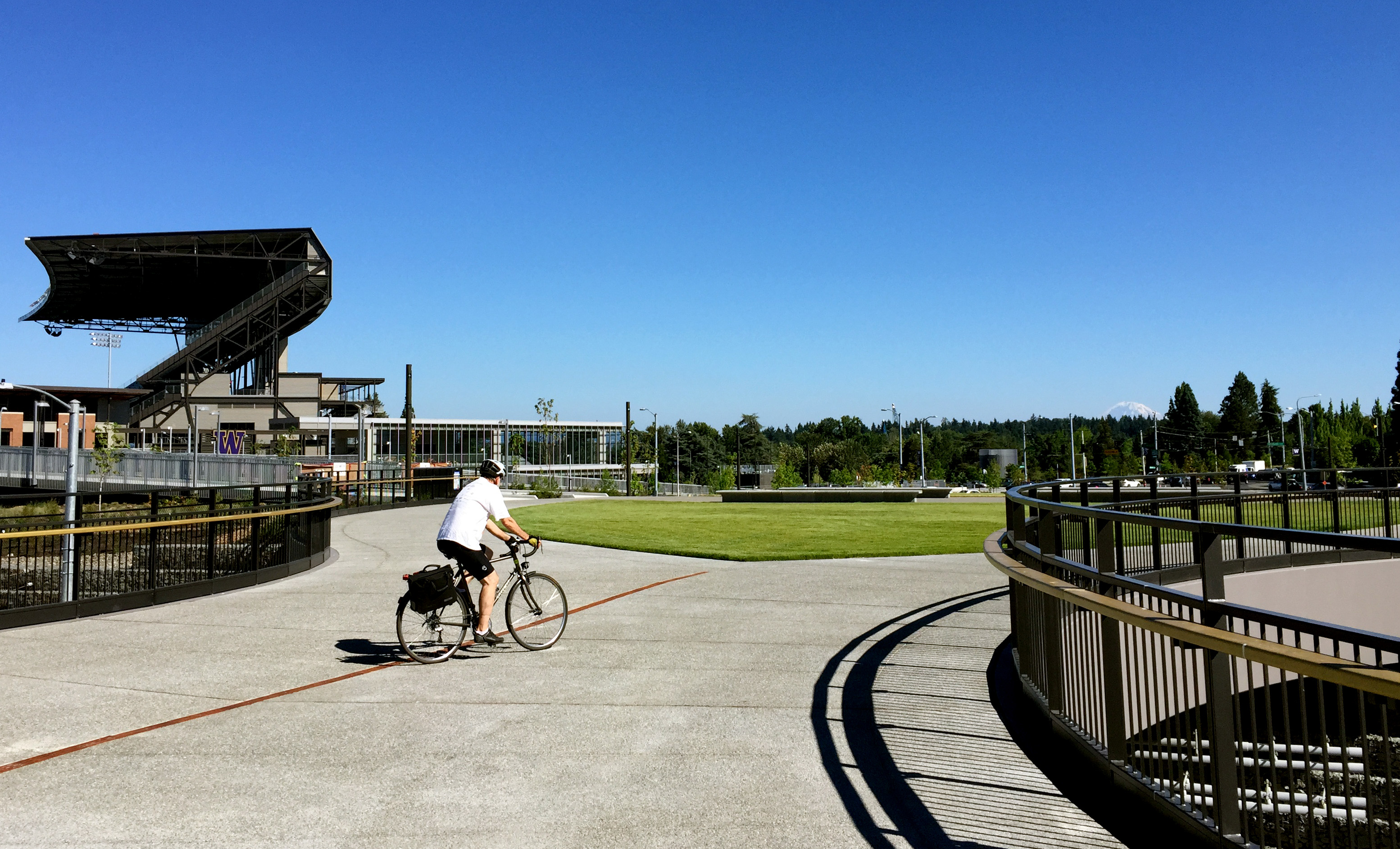
But this area also includes big improvements to the Burke-Gilman Trail, which is finally being treated as a high capacity transportation facility. Already very busy (the trail carries about 1,200 people her hour during rush hour, about as much as a lane of a major freeway), walking and biking volumes are expected to increase significantly when UW Station opens in early 2016.
 The new design works to create separate spaces and quality sight lines for people on foot and people biking through the area. It also creates a bike bypass of the paths leading to the Montlake Bridge and the light rail station, which should dramatically reduce conflicts between the increased walking trips and people biking through. In fact, people biking through may be underwhelmed by the new design because they pass through it so quickly and easily. Of course, that’s a good thing.
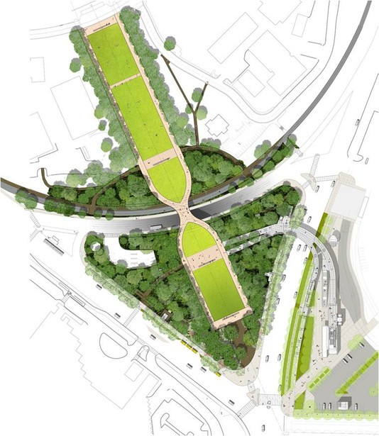
People biking to the light rail station or the Montlake Bridge are routed up through the shared public space and across a land bridge over Pacific Ave. There’s no marked bike route. Rather, people walking and biking mix on the wide paths. It will be very interesting to see how people choose to move through the space, especially once the station opens.
UW designers will be watching closely and are ready to make add signage and wayfinding as it is needed.
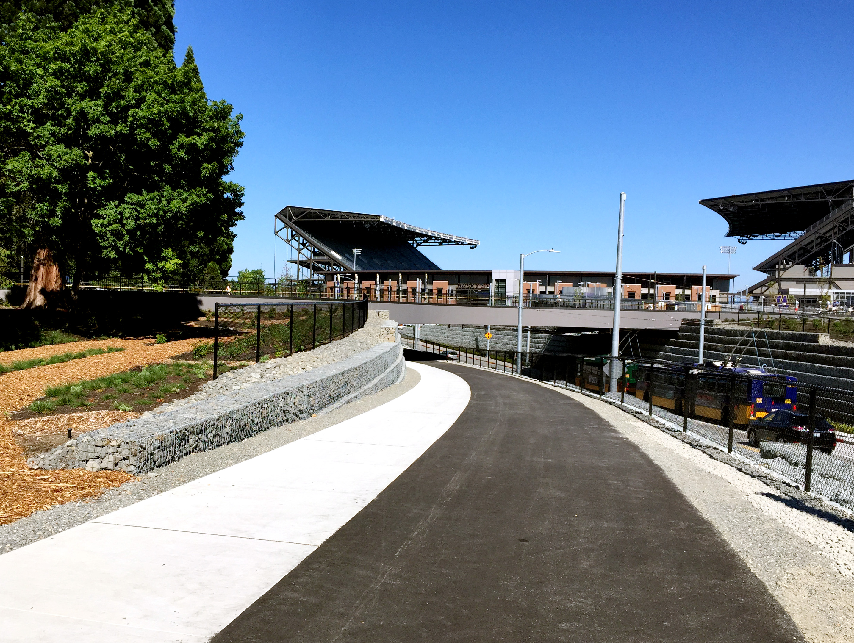
The walk/bike overpass of Montlake Boulevard to UW Station is not yet open, though Sound Transit tells UW they hope to open it this month. In the meantime, there are wide and very gradually-graded paths leading to the crosswalk a block north of the Montlake Bridge.

 Enjoy the trail while it’s open, though. Construction on more trail work is scheduled to start in September, the DJC reports. And if the state passes the rest of the transportation package (ESSB 5988 appropriates this funding and has passed the Senate, but not the House as of this writing), UW will get the $16 million they need to completely rebuild the trail through campus. For more details on those plans, see our previous story on a failed TIGER grant bid.
This much-needed work (so long, tree root bumps!) would happen in phases over years. But for now, the detour signs are coming down.


Comments
40 responses to “The magnificent new UW Burke-Gilman Trail opens”
The work done is brilliant. I rode on it yesterday. It used to be terraced steps coming from the Montlake/Pacific intersection, and now it is accessible. There used to be tons of mixing traffic between people walking to classes from the intersection and people traveling through on the trail. There used to be conflicts with cars when crossing NE Pacific Place. They are effectively treating BGT and the path from the intersection to Red Square as intersecting highways with a clover leaf, and it is brilliant. Bravo!
And also, yes, I was surprised how bad the bumps/roots have gotten on the BGT between Rainier Vista and 25th St NE. There will be some bad spills.
Sounds like a huge improvement. I’ll give it a once-over during the holiday weekend.
Ah, I was going to start speculating about the next time UW would randomly shut the trail down and dump us on the street. Seems like we already know!
The roots need fixing, but they need fixing every year (they were ground down this winter, and there are already new ones) – a full rebuild would probably help with that. I’ve never seen a spill.
And, though I ride it at rush hour, I really don’t think it’s over capacity. Not sure it’s such a great deal to be back on streets for another year or two so UW can improve things (though the new montlake vista is super nice). I’d fix the crossings at Stevens, University and Brooklyn long before I’d widen the trail through campus.
I rode through on the B-G yesterday and was impressed by the trail and the pedestrian overpass. However, UW has thrown transit under the bus (pun intended) to make this gorgeous space. [ http://seattletransitblog.com/2015/06/15/montlake-stops-are-moving/ and http://seattletransitblog.com/2015/03/06/metro-presents-u-link-restructures/%5D
When the stadium Link station opens early next year, Metro will be re-routing buses in the area. Amazingly, even after a re-design, many of the re-routed buses will make passengers walk a significant distance to get to/from the nearest bus stop and the Link station. Why don’t the buses stop right next to the Link station? Good question. Some reasonably grounded theories and some rumors point to UW’s reluctance to give up parking by Husky Stadium, UW’s reluctance to mar the view at Rainier Vista, poor coordination between Sound Transit, the city, and the university, poor coordination within UW, etc. Which is right? Do any of you know?
Regardless, there is no doubt that some blame goes to UW. They are hugely benefiting from the public investment in a Link station right by their stadium and near their campus, but they are not accommodating (for whatever underlying reason) the rest of North Seattle or the Link system as a whole in allowing efficient transfers between buses and Link. So for how beautiful the new Rainier Vista is, for me it is a reminder of how UW can be an inconsiderate neighbor.
I will both enjoy the view and curse UW as I bike through.
This is Seattle. If you want functional connections between multiple modes of transportation you chose to live in the wrong city.
Much like the disconnected and inconsistent bike infrastructure Seattle (all agencies) also suffers from ADHD on every other form of transportation (see single monorail line, single streetcar line, single light rail line, single Express lane facility, single toll bridge, etc.), to expect the city to be able to integrate various modes of transportation just isn’t realistic, but maybe they could build a new gondola line?
The UW also has to confront the problem that a lot of employees are going to be a long way from their workplace at either of the light rail stations. Calls out for some kind of campus shuttle bus.
Because of the indirect routing of the campus roads, a shuttle bus would be slower than walking for anyone not disabled.
Long distances terrible to ST station walkers. I worry how bikers coming north from Montlake Bridge headed across Overpass will intersect with folks exiting ST station going to hospital emergency mass. Looks wild! Of course, Montlake bridge extremely narrow (7 feet in places) and unsafe now – add the higher bike/ped traffic expected and it’s a disaster.
I rode the new section this morning and was a little surprised by how uneven the new asphalt surface is (no bumps like the rest of the trail but rolls). Hopefully this is a result of too few passes with the roller rather than skimping on the underlying trail foundation.
Hooray, open at last and very pretty indeed. A great asset to the beautiful UW campus, though the effect is a little austere. I mourn the loss of the cherry trees that lined the old vista.
But definitely an improvement to the safety of the trail, welcome after a year of chaotic and dangerous detours. At this point, with a little interlude before the next round of construction on the BGT, perhaps UW transportation service will re-evaluate their handling of the bike detours.
For example, how many accidents happened on the detour route? What can be done to prevent such accidents in planning future detours? Will the UW commit to bicyclist and pedestrian safety as their first priority? Will new contracts specify that access to the trail by bicyclists be made available as soon as possible (access to the vista underpass was available to auto drivers months prior to other users)?
To their credit, they did at least open the sidewalk to the underpass at the same time as the road opened for 2-way car traffic. It was the one-way configuration period where the sidewalk was closed. Even then, lots of bikers used the road, which is legal, just like riding on any other road. With a 20 mph speed limit, the temporary road never felt unsafe to ride on (although lugging the bike up the stairs at the end was certainly a nuisance).
Nice to see some improvements. Any plans to continue fixing the rest of the trail? It may be one of the busiest trails in Washington, it’s also one of the worst. North of UW is a mess..
Answer found in article… ;)
I am heading out from downtown in a few minutes and the BG trail is part of my commute, I saw the fence was down this morning on Stevens Way. Excited to check it out.
The design looks elegant and functional – a huge upgrade from what was there, but I agree they should have developed a more efficient transfer layout for buses for the light rail. They will need more bike parking at the Link station too.
About time. Anybody who’s been watching the progress knows the BGT part of the project has been done for over a month.
Is there any possibility of getting a Pronto station somewhere on the Montlake Triangle? Even if there’s no money for a new one, they could at least move the station from the back of the med center, which is hidden, to the triangle, where it will still serve the med center, but also serve nearly UW buildings and be a lot more visible.
absolutely beautiful.
I could nitpick on the design, but I won’t.
Totally agree on the transit non-sense. They need to either widen Montlake and add a HOV/bus lane, or they need to make one of the current lanes HOV. Otherwise, no matter how many stops are moved closer to the station, transfers will still suck.
UW is not a good friend or partner to non-car transportation initiatives in the city, but they sure can build a pretty vista.
Glad it finally opened, but not glad they removed 50 mature cherry trees to do it
With so much open space, I don’t see why the Cherry trees couldn’t stay. They could have at least planted new ones.
Totally agree. Less grass, more trees, please!
Regarding the view from the Vista,
Tom wrote,
just one more of her magical powers: She only poses for high-quality cameras.
Her real name is Talol or Tahoma, for people from around here. Around the southern Salish Sea, Tahoma is as Alaskans say, “McKinley never saw Denali.” Similarly topographically prominent, the real names have approximately similar meanings in their respective languages.
; )
Boy was I surprised this morning. But on the way back I forgot and took the detour.
I can agree the new thing is pretty, but I’m a little confused about Pacific pl. It looks like a lot of cost for what is basically a glorified turn lane. Wouldn’t it have made more sense to have one rather than three intersections? Then again, given the traffic volume, a single intersection there might end up like Mercer & Fairview. But considering we’re already springing big for ped overpasses and ramps, we may as well have a more normal car setup. Guess it’s too late now. Still time till they pour obscene quantities of concrete to super size the dysfunction of Montlake and 520.
It’s a glorified turn lane combined with a glorified bus turnaround. The turn lane is far enough back from the bridge that it lets at least some people that aren’t crossing the bridge avoid backups when the bridge opens. The bus turnaround is in basically the only place it can be on the current street network. In the one-intersection scenario Montlake/Pacific needs a left-turn lane, which would also need to accommodate access to the Husky Stadium parking lot, and buses could theoretically turn around there, but that might cost UW a couple dozen parking spaces that are needed for a half-dozen football games per year, so it would be a fight.
Some people won’t nitpick on the design, but I will.
The practice of architecture has degenerated the question of how a design looks from an airplane in simulation. Whether it works on the ground is secondary. Let’s put unnecessary sharp turns in the way for people biking from the BGT to the Montlake Bridge — otherwise my design wouldn’t be symmetric! Let’s not even mark the paths we expect people to use, because centerlines aren’t pretty! Who cares whether people can figure out where they’re going? Who cares about sightlines? If all these cyclists cared about getting places they’d be driving… or flying aircraft in simulation!
Olmstead designed many excellent parks; he also designed a lot of roads, both inside larger parks and as stand-alone boulevards, and they’ve mostly held up very poorly in the face of urban traffic. He can hardly be blamed — nobody at the time anticipated today’s urban traffic patterns, or how the extent of cities would scream past greenbelts, leaving all interior roads traffic-choked. Today we’d expect someone designing roads, especially in parks, to have some understanding of urban traffic and to have a credible plan to manage it. Similarly, we should expect people designing important bike paths to understand common transportation cycling patterns. Any praise I could give the designers for grade-separating Pacific Place and BGT through-traffic would be damningly faint.
As for comparisons to Cal Anderson… Cal Anderson is surrounded by city streets busy with foot traffic on every side, and it’s permeable along most of its perimeter. Rainier Vista sits between various campus buildings but blocks off paths between them.
Or we could compare it to the old Rainier Vista. With the parking aisle down the middle and the cherry trees there was plenty of room to walk up and down it, which was all you could do. Now the parking aisle is gone but you can still only walk up and down it, and with the cherry trees gone it’s just an expanse of lawn, a quad with nothing on it.
That’s another comparison where it comes up short: against the many great grassy quads of American universities (example). These work for the same reasons Cal Anderson does: they’re surrounded by activity and open from all sides. In fact, with academic buildings right there quads are popular hangouts even when they don’t have any specifically popular features. Rainier Vista, by comparison, is just a view in a town where views are a dime a dozen.
Those aren’t “unnecessary sharp turns,” they’re passive speed control measures anticipating the mixed-mode use in the area. Think of it like how we narrow streets to make cars slow down. You’re welcome.
You’re already slowed down by climbing up from the Burke and being tossed out into an undifferentiated land-bridge, every bit of which is a conflict zone.
Note that it is not, in fact, impossible to provide a clearly marked bike path across a quad (in this case an actually useful quad) that lets you travel in a straightforward path.
That crunching sound is the needs of transportation cycling being stepped on by a “placemaking” trend machine, driven by some landscape architect that doesn’t know a thing about placemaking or cycling.
Al, having visited UIUC and observed class changes, I can attest that those paths are paved because of student activity in the area as they bustle amongst those teaching buildings you pictured. The re-done vista area of UW is not really amongst teaching buildings so there’s little need for that much pavement across it.
I studied at UIUC and rode an old Schwinn (a stylin’ two-speed hub-geared cruiser with coaster brakes, made in Chicago like all good things) around campus for four years.
My point is not that we need that much pavement, it’s that we need a small strip of the pavement we have designated as the bike route, in a reasonable shape for a bike route. One of those paved paths on the UIUC quad is a bike path. Look closely at the image — it’s a narrow east-west path. It has a yellow-dashed center line and little bike symbols. Most people biking to the quad for class park on the perimeter of the quad, but people that want to go through the middle do so on this path instead of plowing through the crowds on the pedestrian paths.
On the new Rainier Vista the pavement is an undifferentiated “mixing zone” because we’re in the middle of an “open space solves everything” fad, and none of the pavement is in a path people biking or walking between the BGT and the bridge over Montlake would naturally choose. That’s a big sign the paths are designed wrong.
But more generally the “open space solves everything” fad is wrong. Yes, people biking and walking are capable of sharing space. The ability of most cyclists to handle shared space and close quarters humanely is one of cycling’s true virtues as a mode of transportation (it’s one of the reasons cycling is worth promoting as a way to get around cities, and not just a silly hobby). But it’s a hell of a lot easier and more efficient for everyone when paths are set out that put the conflict points in consistent places. The only explanations for Rainier Vista’s design are ignorance, laziness, or vanity.
(BTW, having studied at UIUC, and biked around and through the UW campus for the last 5 years, I saw the LAB list of bike-friendly campuses, listing UW a couple tiers above UIUC, and laughed. 100% hype-driven nonsense. UIUC’s mature, connected network of cycletracks is like living in a Copenhagenize post.)
[…] The magnificent new UW Burke-Gilman Trail opens | Seattle Bike Blog. […]
[…] of the Montlake Triangle/Rainier Vista has reopened, including the Burke-Gilman rebuild, and Seattle Bike Blog loves it. (Thanks to this week’s transportation package, the Burke will also get $16m to fully rebuild […]
[…] Viewpoint – Breaking Muscle – Base 2 Space Stair Climb – Space Needle – The Magnificent New UW Burke-Gilman Trail Opens – Seattle Bike Blog – Five Steps to Increase Emotional Maturity – CrossFit […]
[…] Can’t wait to give the Rainier Vista portion of the Burke-Gillman Trail a […]
I agree with one of the points that Al made: the on/off ramps from the BGT up to the vista (at least the one on the west side) need to allow less sharp turns. It is not safe to require all people heading east and going to the vista to have to effectively stop in the middle of the BGT to take a very sharp turn left. Similarly for people coming from the vista to head west on BGT, it would be safer to allow people to merge in at a speed greater than 1 mph. Currently these sharp turns are creating a lot of potential conflicts on the BGT itself, where the heaviest volume of traffic is.
I understand the desire to slow bikes around people walking, but the peds and bikes should be separated here rather than effectively creating an all-way stop without stop signs (and with east/west traffic not needing to abide by the stop signs).
I don’t miss Seattle and the so called trail one bit. Another reason not to support Seattle politics or the UW, transportation for cyclists will always be a joke in this town.
Please don’t export this to Whidbey Island, and to where I commute now 800-1K a month on my Surly.
[…] bridge connects to the newly redesigned Rainier Vista public space and trail connection on UW campus. If you haven’t already checked this out, […]
[…] was the kids’ first time riding their own bikes on the new Montlake Boulevard walk/bike overpass so that was fun, too. We rode it recently with a group of friends, but it’s different when […]
[…] know you just started enjoying a fully open Burke-Gilman Trail, but it goes back under the knife […]
[…] to remake the trail in the station area. The area connecting to the station (dubbed Rainier Vista) was completed last year, providing an underpass trail for people continuing through and creating new access points from the […]