
 The bike route for people trying to navigate the Highway 99 construction area in Sodo and downtown has a habit of changing on a regular basis. Get ready for another big change Monday as WSDOT opens the new Atlantic Street Overpass.
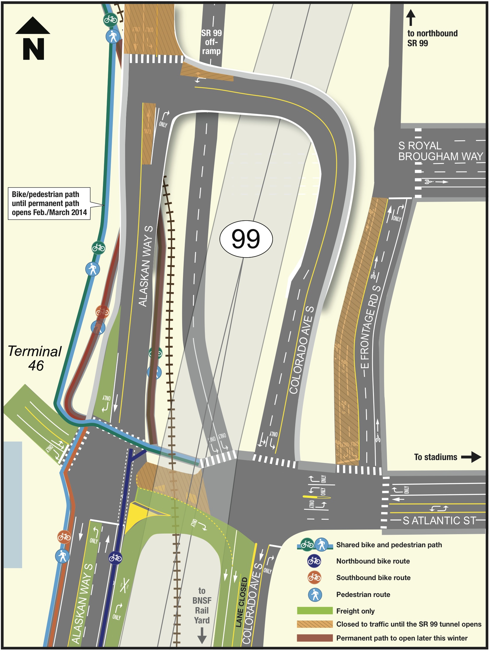
You will also be able to get around a train blocking Atlantic Street by using the new overpass (sidewalks may not be ready as of Monday), which is pretty cool if you work in Sodo.
Later this winter, a new trail that goes underneath the overpass will open. Looking at the map to the right, however, I shudder to think of how dangerous this area will be when the on- and off-ramps for the Hwy 99 tunnel open. The Atlantic/Hwy 99/Colorado Ave/Frontage Rd intersection is massive and crazy.
Perhaps avoiding this mess is another argument for cancelling the tunnel. The new overpass is a good idea, and much-needed for freight movement. But I find it hard to believe the tunnel opening is going to help traffic in this area.
More details on the changes, from WSDOT:
History has shown that it can take a few days for drivers to adjust to changes in their usual travel routes. Vehicles approaching South Atlantic Street from the western leg of the overpass will need to cross the bicycle/pedestrian path. That includes freight turning right into the Port of Seattle’s Terminal 46. Please use extra caution and be mindful of traffic as you approach this intersection. Signs on the overpass will warn truck drivers of bicyclist and pedestrian crossings; similar signs on the bike path will warn of truck crossings at the intersection.
A map of the new overpass is attached to this email. Below is some key information about the new road configuration:
· The section of South Atlantic Street beneath SR 99 will remain closed to through traffic until the SR 99 tunnel opens to traffic. Drivers will instead use the new overpass to travel in both directions between South Atlantic Street and Alaskan Way South.
· Bicyclists and pedestrians heading east or west can use the sidewalk on the north side of South Atlantic Street or use the new overpass when a train blocks the tracks. *Please note, the sidewalk on the overpass will not open until late in the week of Jan. 27.
· Truckers can use new freight-only lanes on northbound East Marginal Way South and eastbound South Atlantic Street to get to the new north entrance to the BNSF rail yard on Colorado Avenue South.
Future improvements to the bicycle/pedestrian path
Scheduled to open later this winter, a significant feature of the new permanent path is a changed alignment that will improve sight distance between bicyclists and trucks at the western leg of the overpass. Final design for the new path was completed with input from stakeholders to ensure bicyclists and pedestrians have safe access between West Seattle, SODO and downtown neighborhoods.
Features of the new path will include:
· Completion of the link between the new path from South King Street and the on-street bike lanes south of South Atlantic Street.
· Dedicated shared-use path that is 14 feet wide.
· Improved paving.
· Overhead lighting features.
· Signs warning of vehicles crossing the intersection of Alaskan Way South and South Atlantic Street.
· Landscaping (to be completed at a later stage).


Comments
19 responses to “Opening of Atlantic St overpass means more Sodo waterfront bike route changes”
This intersection has been problematic from the get-go of the construction. The light cycles clearly favor motorized traffic and oftentimes the pedestrian “button” is fully inaccessible to those using the path southbound. The light signal for cyclists heading northbound on E. Marginal, crossing Atlantic to access the path, has been regularly recognizing cyclists in the last several months but remains way too short (only allowing maybe one or two cyclists to traverse the large intersection at at time – barely). Cyclists, pedestrians and drivers already regularly run the red light here, setting a bad precedence for intersection users.
Add to this trucks that could be coming off that bridge southbound to turn right into the port, crossing the frequently used bike & pedestrian crossing and it could be disastrous. Especially if right turns on red are permitted. I do hope that SDOT will be placing large, noticeable warnings for both path users (to watch for trucks coming from the left) and drivers (warning of the path) that there is a significant traffic-flow change. I will be riding very, very carefully through that area.
It’s interesting to click through WSDOT’s interactive graphic of the south portal construction phases: http://www.wsdot.wa.gov/projects/viaduct/Traffic/SouthPortal
My impression is that, as far as bicycle traffic is concerned, the final result might actually be much better than even the current configuration, which is good news!
The thing I’m most concerned with, though, is traffic on E. Marginal south of Atlantic St once the overpass opens and Atlantic is no longer effectively dead-ended by the rail crossing. Then it will (once again) become a tempting alternative route for drivers avoiding Hwy 99, as it was back before construction started. E Marginal is dangerous enough as it is, with its relatively low current traffic levels. Adding thousands of impatient auto commuters to the mix is a recipe for disaster. I really wish the city would prioritize a 2-way, protected bike lane/cycle track along this stretch.
While research (e.g., Lusk’s most recent study) generally show two-way sidepaths are more dangerous in city street grids, E Marginal could actually be one of the exceptions because of its low intersection density, assuming proper controls at driveways.
I know it’s been discussed before, but it might actually work best to have a 2-way protected facility to be on the *east* side of the street: it would require an extra crossing near the WS bridge, but there are zero driveways between Hanford and Atlantic. That being said, the driveways there are used little enough that a west-side path could easily be designed to be very safe.
What Jake and Aili said!
Did they seriously just use bike-lane green to designate “freight only” lanes on that map? *facepalm*
If the main audience for the map is truckers (probably the case, given the locale) then that makes tons of sense. Green means go, we cyclists don’t have a monopoly on it.
Yikes.
Rode northbound through the new intersection this morning. On a green light, the NB bike lane shoots you straight into the intersection as if you were going to continue on up the overpass. Hard to tell in the dark, but the NE curb where you might otherwise stop and wait for the light to cross West looks really small and wouldn’t be able to support more than 1 or 2 bikes waiting. Might be best to get into the left hand turn lane with the trucks in order to get to the bike/ped path on the West side of the overpass (or get on the sidewalk down by “Lake Marginal”).
Even though I was mentally prepared for the change, I wasn’t prepared for getting (or feeling) caught in the open in the intersection. Let’s hope they get the path on the East side of the overpass completed ASAP.
Agreed. Out of instinct, I merged over to the left turn lane this morning, and I’m glad I did. Unless more is done to remedy it, this is going to be a real mess until the path under the overpass is open.
Looks on the map like they do expect you to wait on that NE corner, not use the turn lane. There’s no bike routing indicated that would take you through the intersection and onto the northbound trail other than a last-minute dodge to the right.
Hope most riders who arrive there are at least aware enough to wait for the light instead of making a left in front of overtaking traffic. If two-stage left-turn boxes were legal at 4-way intersections, this definitely looks like a place where cyclists have no safe space to wait.
Yes. The solution in it’s current condition is terrifying at best. It’s astounding to see a police officer just stand as a spectator as countless riders enter the intersection with nowhere to go. This is a major accident just waiting to happen and needs to change sooner rather than later.
that was precisely my experience this morning. there were several trucks ahead of me making it difficult to see what i was approaching. i followed the bike lane right into the intersection and was left with no choice but to bail over to the NE corner because the trucks were going straight up on the new overpass and i had nowhere else to go.
really baffled as to the intent of the police car sitting there. wasn’t doing anything but taking up space.
Perhaps the police are waiting to clear the expected collisions?
2 off ramps, 1 on ramp, Port of Seattle truck traffic and a train crossing…what could be more dangerous for bicyclists and pedestrians? After commuting through the Atlantic street danger zone twice since the “re-route”, I have opted to avoid it altogether in favor of a slightly less dangerous route. Southbound: Alaskan Way under the Viaduct continuing onto 1st Avenue. Northbound: Utah Avenue to Frontage road, then left onto 1st Avenue to Alaskan Way.
As a daily commuter, someone who rode the detour nearly every day, I was likewise confused by signage on the new route. Had to think for a minute whether to go up the overpass. Even though I had read this article beforehand.
After using this area twice now…I have a few issues.
Accessing the “bike/ped path” northbound is EXTREMELY sketchy. The bike lane ends heading northbound only at the light. There’s no left turn light for the bike lane and no crosswalk on the east side of the intersection to use to cross. To access the west crosswalk one has to enter the sidewalk several blocks south and know how/why to do so. I am not sure if a cyclist will trigger the left turn only light to enter the Port…has anyone tried this option? In any case I am very concerned that a cyclist will be struck by a motor vehicle as they try to cross the northbound bridge access lane – a bad, bad decision by SDOT/WADOT to not reconfigure this approach for cyclists. B
Be aware that there will be oncoming (southbound and turning) traffic to deal with as cyclists try to access the path entry that empties/enters in the right turn only vehicle lane. If that’s blocked by trucks it will be impossible to get to the path (the rest is gated off right now).
There is a very small “landing pad/sidewalk” with room only for one or two bikes to wait and there’s no room for other cyclists to pass if others are waiting for the light there (i.e. to travel southbound cyclists have to activate the “pedestrian button” which is located behind and to the left of where cyclists leave the path…I had to do a 180 with the bike to use this signal – impossible if others were there.).
This whole intersection needs to be re-done. 1) no turn on red 2) Bike only lights 3) decent waiting area and access to it for cyclists trying to cross southbound and for cyclists getting through northbound 4) reconfigure bike lane northbound to get cyclists across intersection in a more safe & rational manner (i.e. bike signal!). It’s going to be a mess there in the spring when less seasoned cyclists ride through.
First time through there this morning and I was totally lost. The only “Bicycle Detour” sign I found directed me eastbound towards First Avenue with no other instructions. With all the fencing in place, I couldn’t even tell for sure that the west side multi-use path was open. I guess I just couldn’t believe what the real route was supposed to be.
Tomorrow I will probably try getting on the Westside sidewalk just south of the Coastguard station, I don’t like taking the sidewalk past the entrance to the terminal just south of the Coastguard. What a mess….
[…] The Washington State Department of Transportation opened a new overpass at S Atlantic Street to help people bypass a sometimes frustrating railroad crossing near Alaskan Way S. But people on bikes were met with frustration and confusion when the overpass opened last week. […]
[…] the overpass opened to traffic early this year, the bike path connection was not yet complete and many people voiced concerns that the new […]