

After an unprecedented number of hours reaching out to community groups, industry and commercial stakeholders, and the public at large, the Bicycle Master Plan update is finally in the hands of the City Council.
The plan represents an impressive and unprecedented amount of community input and expert consultation on challenges and opportunities to make Seattle the best city for bicycling in the nation. It includes an innovative vision for Seattle streets that encourages health and economic prosperity in every neighborhood, with an emphasis on reaching low-income areas that bear a disproportionate number of traffic injuries and deaths.
It is quite likely the best bike plan in the nation. As Mayor McGinn’s office sends the plan to the City Council today, it is just one step away from gaining approval.
The plan represents many compromises. It’s not this bike blog editor’s dream plan, but that’s probably a good thing. Potential conflicts with transit expansion plans or freight mobility were taken seriously by the plan’s authors, and that should give the plan credibility. It is not only bold, but also realistic. It was not created in a bikes-only silo, but conferred constantly with the freight advisory board and heavily referenced the existing transit and pedestrian master plans.
The plan dramatically improves on the important-but-flawed 2007 Bike Master Plan.
“Probably for its time, it was just fine,” said outgoing SDOT Director Peter Hahn. The 2007 plan has been widely criticized for focusing on encouraging people on bikes to share lanes with car traffic on busy streets (thus, the reason so many busy streets have “sharrows” painted on them). “Due to compromises at the time, sharing lanes lead to some friction.”
The new plan focuses on protected bike lanes and neighborhood greenways to create a connected network of bike routes that will be comfortable to people of all ages and abilities while also improving neighborhood safety in general and reducing all types of traffic collisions. Hahn hopes this focus on reaching out to all Seattle residents — not just those brave enough to bike mixed with heavy traffic — will garner the plan “tremendous support across the community.”
“Certainly, there were some elements of controversy and probably will continue to be, but this is our best shot at it,” he said.
Adopting the plan does not come with a fiscal note, but it will put pressure on incoming Mayor Ed Murray and the new City Council to come up with a plan to adequately finance improvements and stay on track to complete most or all of the plan within 20 years. To that end, Mayor McGinn is urging the Council to adopt the goal of incrementally growing the budget for bicycle-related improvements from the current rate of $7-12 million to $20 million. From McGinn’s letter to the Council:
I also propose that the City Council set an annual funding goal of $20 million, which will be required to implement the improvements identified on the bicycle network plan map over the next 20 years, according to the planning-level cost estimate for plan implementation. In recent years, annual funding levels for bicycle facilities have been between $7 million and $12 million. With potential opportunities for bicycle funding increases in a renewed Bridging the Gap Levy, renewal of the Parks and Green Spaces Levy, a new local funding option approved by the legislature, continued availability of grant funding, as well as an improving economy, an incremental increase to $20 million a year is an attainable policy goal.
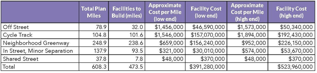
The raw total price tag for 474 miles of new and upgraded bike facilities clocks in between $391 million and $524 million. That estimate is full of caveats, though, and should not be taken at face value. It includes all elements of implementing the plan, including staff time and elements of projects geared toward the safety and access of other modes, such as improvements for people on foot. It also does not factor in the fact that SDOT’s biking and walking program has a great success rate at securing grants to assist with costs.
That price also excludes the reality that a great many of these projects will happen in conjunction with other projects (repaving projects, utility work, etc) in which the costs would be shared. The Broadway Bikeway, for example, largely paid for itself because it was built on top of a bunch of utilities that the First Hill Streetcar project would have otherwise needed to move. SDOT is actually pretty good at combining projects to maximize the investments from other city work.
And, of course, the “cost” of these bike projects does not factor in savings in the form of increased economic activity often accompanying high quality bike projects as well as the cost savings associated with a healthier population. And what is the value of saving lives from traffic violence? It’s hard to place such values into an economic context.
Here’s the plan’s cost breakdown:

 Moving forward, the City Council, which has been active in the development of the plan from the start, will discuss the plan through December and will hold a public hearing. They expect to vote in early 2014, meaning the Bike Master Plan might be one of the first major documents to bear Mayor Ed Murray’s signature.
Of the thousands of comments received on the plan, NE 65th Street received by far the most attention. The plan includes a NE 65th Street option that is an attempt at compromise, though it will likely disappoint some people who bike in the area and some neighbors who opposed any protected bike lanes at all on the street. During community outreach, the option they went with was known as Option C.
The plan also changed plans for protected bike lanes on Stone Way, instead planning a neighborhood greenway on Woodland Park Ave. These changes were made at the urging of several neighborhood groups.
For our coverage of how the plan got to this point, see our BMP archives. Stay tuned for more details on changes, which we will post once we get a digital copy of the plan.
UPDATE: Here’s the schedule going forward, via SDOT:
- SDOT presentation and discussion with the Seattle Bicycle Advisory Board (SBAB) on Wednesday, December 4
- SDOT presentation to City Council Transportation Committee on Tuesday, December 10
- Special meeting of the City Council Transportation Committee on Wednesday, December 11 to take public input on the recommended plan
- Additional deliberations by City Council on the recommended plan will occur in early 2014; dates of subsequent meeting will be posted on the project website.
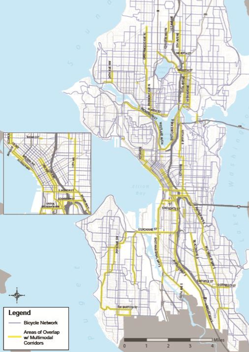
Below is the full system map. You can download the full plan from the SDOT website.


Comments
52 responses to “Bike Master Plan heads to City Council, presents bold vision of strong, healthy streets in every Seattle neighborhood”
Just curious, why do greenways cost twice as much per mile as “in street, minor separation” (road diet/bike lanes)?
The x-factor in these projects is the intersections. As we all know well, painted bike lane projects rarely do much if anything to intersections and traffic signals. Neighborhood greenways, on the other hand, include new crossings at busy streets. These range from concrete islands to full traffic signals, which account for that cost.
That’s also the reason the cycle track cost is so high: It assumes intersection changes, like bike-specific signals.
I just don’t understand how Greenways ring in at almost a million a mile. Those humps of asphalt must cost $200,000 each, at that rate. Most greenways should only require a few stop signs and wayfinding signs, a little paint and maybe a speed hump or 3, maybe.
Possibly something fancier at arterial crossings might be needed. Maybe that’s the big ticket item?
The price assumes full intersection treatments at busy streets. Also includes things like outreach, staff time, some repaving, etc.
I think it’s money well spent, but at that rate we will be lucky to get another mile or two per year. It sounds like achieving the famed Seattle consensus is bloating each of these projects significantly.
Maybe a more quick and dirty greenway template we can incorporate as a first step “as an interim testing phase” which can get installed first, then gold-plate with humps and crossings as the neighborhood cranks grow weary/accepting and money becomes available.
Great question! Part of the greenway improvements have included sidewalk fixes and repaving. Those are super expensive, and SDOT has no budget (at all) for sidewalk improvements and residential street repaving.
And in case I wasn’t clear enough: since they have no budget for it, repaving/sidewalk fixes comes out of the cost of the greenway implementation.
Yes! I forgot about the ADA improvements, like new curb cuts. Those cost a shocking amount of money, but are vital to what a neighborhood greenway should be.
I don’t think the greenway up at 27th in Lake City is getting sidewalks, though correct me if I’m wrong. I also don’t think it is getting fancy crossings. That kind of greenway should be a much, much cheaper.
That’s my understanding for 27th as well. However, in places where there are existing sidewalks in poor conditions (which the adjacent homeowners are legally supposed to fix), SDOT has fixed them during some greenway installations. They view it as protection against liability – it is cheaper to fix the sidewalk than to pay out for lawsuits from people who are told that the greenway is an excellent walking route but broke their ankle on uneven sidewalk.
Sounds like there should be 2 rates. South of 85th, a million a mile.
North of 85th, 100K per mile. We could fill out our entire grid up here in the low-rent district in a couple of years! And we certainly need it more. Being that we have no sidewalks and all.
I’m confused at to the new, to my eyes, distinction between city-wide and local connectors. Particularly with regards to Greenways.
Ouch! :)
The city-wide vs local connector distinction is largely a way to guide investments and to make sure connectivity to the larger network is adequately considered. The local connectors provide access to areas that need safe routes nearby and typically plug into the city-wide network. That’s the thinking, anyway.
Thanks Tom. Makes sense, in theory. I don’t recall that distinction when I went to the open houses. Must be a new wrinkle. Actually more likely is it’s a wrinkle on my old brain.
They first implemented it in the second draft. So if you were at a meeting about the first draft, then you would not have seen it.
A greenway on 27th without decent crossings of 125th and 145th would be pretty meaningless. Maybe that’s what they’re proposing, but it would be awfully silly. The Wallingford greenway, with no solution for I-5, no improvement at Wallingford Ave, and a cheapo median at Stone Way, hasn’t really changed things much for getting east-west in that corridor. The Ballard greenway, with its excellent arterial crossings, has. The Fremont Ave route through Greenwood isn’t a greenway in name but works like one, and it works really well, primarily because of excellent arterial crossings at 80th, 85th, and 105th.
It looks like NE 65th gets an improvement over “Option C”. There’s minor separation (aka a road diet w/ bike lanes) for east of 25th Ave NE. That will be a huge improvement over what’s currently there.
I counted parked cars yesterday on the west side of that hill at around 7 or 8pm last night. 0. Zero. Zilch. Not a single car was parked on that side. And, of course, I was passed on the right by an impatient driver as I drove on the street.
Yes, there are also bike lanes between Ravenna Blvd and 1st Ave NE, which was not originally part of Option C.
The lanes indicated on this map between 1st and Ravenna are already there (indicated by a solid, not dashed line). The original Option C map may have omitted them in haste. Today, 65th has a bike lane westbound (uphill) from Ravenna to 1st and sharrows eastbound (downhill), and this map indicates that the BMP doesn’t call for a change.
Just to put those costs in perspective: the population of Seattle is a little over 600,000, so that $20 million/year funding goal is still less than $33 per resident per year. That really shouldn’t be such a hard sell!
That is a huge increase when added to all the other taxes paid. This is a hard sell in any city.
Dividing expenses by people seems like a straight-forward way of looking at tax burdens, but it presents a skewed picture. Taxes aren’t shared equally across all citizens. Property and B&O taxes, both of which are at least modestly progressive, account for nearly half of the city’s revenue. As a result, Seattle is able to collect the $4.4 billion necessary to cover the expenses in its 2014 budget without taxing every family of four $29,000 to cover the bill. In other words, Seattle, to a substantial degree, taxes money, not people. It works like this everywhere. So, the next time something sounds too expensive for government to do — any level of government — remember that it’s the money that matters, not the number of people. Remember, too, that the amount of money sitting around doing nothing today is unprecedented — we are rich as a people, it’s just that only a few people control the bank accounts.
I’ll read it later, but my first reaction is that it’s disappointing and surprising that it doesn’t seem to directly touch the topic of gender equity in any meaningful sense.
In this specific sense, it is already a decade out of date relative to best practices in Denmark, the Netherlands, etc.
On p. 113, Table 7-8 – percentage of women, as well as percentage of older people and people of color who ride a few times a month or more is now among the performance measures used to judge the City’s effectiveness in meeting the Plan’s stated equity goal.
I just spent an hour reading the plan and I am a lot less enthused than Mr. Fucoloro.
Despite having excellent demographics and reasonable climate for cycling, the existing bicycle network in Seattle in poor and to the extent that the city has had a plan it has been implemented in an ad hoc manner so that the current network has lots of gaps (map 2-3 on p17) and is in my view often poorly designed (for example bike lanes sandwiched between fast moving traffic and parked cars that provide cyclists with little room and obscure cyclists at intersections). In the BMP, Figure 2-3 shows lots of apparent progress in 2007-2012 EXCEPT that there has been no increase in bicycle ridership. Why? Where is this big failing of past efforts discussed in the new plan. It is not – instead it is conveniently ignored. How can a city with so much bicycle activism and a supportive mayor make so little progress?
The report states “The proposed bicycle network map is the result of a collaborative planning process involving both extensive public input and technical analysis”. There has been lots of public consultation. I am however having trouble identifying the technical analysis other than a criteria that there needs to be increased levels of separation with increasing traffic levels (see Table 4.2).
There are lots of maps with bicycle routes but where can one find a technical explanation as to why particular streets have been chosen and why the network is the way it is. Where are the projections of future ridership? How can one make a sensible bike transport plan without such data? Where are the discussions of lessons learned from Seattle and from other cities in the US and abroad? Where is the technical analysis documented?
Because this bicycle plan and priorities is so strongly influenced by public input that does not seem to be balanced by a sound technical data that can also justify the choices, I am concerned it will be subject to extensive debate and modification driven by activists and entrenched interests. What we may end up with is a half implemented plan where the half that is implemented is the cheapest and least controversial rather than the half that moves us to an integrated bicycle network.
[…] Seattle Bike Master Plan on its way to the Council. […]
I note that despite multiple rounds of public comment, the BMP continues to recommend infrastructure that violates Washington State law, MUTCD adopted standards, and the Seattle Municipal Code. Would it really kill them to provide careful legal review before inviting liability with designs FHWA has specifically condemned?
Is that you Josh B? Throwing down the gauntlet for future legal challenges if some element of the plan grazes your clients’ home turf? Just wondering….
Different Josh.
Different Josh, no clients to contend with, just a daily Seattle bicycle commuter with a bit of background in insurance, liability, and planning. While it’s true the city would be inviting some significant liability with what’s in the current BMP draft, I won’t be making a percentage either way. I’d like a BMP that respects the law, or recognizes conflict with existing law and lays out needed changes, rather than simply ignoring the law because bicycles don’t have to be taken seriously as vehicles on the street.
FHWA has established that nearly all the treatments in the NACTO Urban Bikeway Design Guide (http://nacto.org/cities-for-cycling/design-guide/) meet current standards while encouraging cities to pilot the few that are not already approved (http://nacto.org/wp-content/uploads/2013/09/design_flexibility_memorandum_092013.pdf ). FHWA is also sponsoring pilot projects and working with NACTO to get all the Design Guide facilities through the MUTCD approval process. FHWA regularly updates the approval status for all the NACTO designs (http://www.fhwa.dot.gov/environment/bicycle_pedestrian/guidance/design_guidance/mutcd_bike.cfm)
And FHWA has confirmed as recently as mid-November that the nonstandard sharrow variants illustrated in the BMP and currently in-use in Seattle are not approved, are not currently the subject of approved experiments, and should not be used.
http://mutcd.fhwa.dot.gov/knowledge/faqs/faq_part9.htm#mkgsq6
FHWA has also confirmed that combined bike lane/right turn only lanes are not approved.
http://mutcd.fhwa.dot.gov/knowledge/faqs/faq_part9.htm#mkgsq8
Q: I recently read in a nationally endorsed compendium of treatments for non-motorized vehicles that a bicycle lane approaching an intersection can be combined with an exclusive turn lane because there is insufficient lateral street width to facilitate the bike lane otherwise. Is this recommendation compliant with the MUTCD?
A: No. Figures 9C-4 and 9C-5 illustrate examples of how the bike lane and exclusive turn lane continue to be separated as they approach the intersection. There is no substantial research that quantifies whether combining the bike lane into the exclusive right turn lane yields a discernible safety benefit. In fact, both safety and legal concerns have been reported thereon in field applications of combining the bicycle lane with a turn lane. Combining a marked bicycle lane with an exclusive turn lane currently requires experimental approval, but facilitating the bicycle lane through the exclusive turn lane can be done at the present time if Shared Lane Markings are used instead of bike lane markings.
Q: Can I alter the design layout of the Shared Lane Marking (see Figure 9C-9) such as rotating the leading chevrons to indicate advance turns for navigational direction?
A: No. Altering a standard marking symbol that results in an alternate meaning or potential unintended connotation is not permitted per Paragraph 1 of Section 3A.02.
Q: Can I alter the design layout of the Shared Lane Marking (see Figure 9C-9) such as duplicating the leading chevrons on the trailing end but in the reverse direction to insinuate that bicycles are permitted to travel in both directions on the facility or lane that it is installed?
A: No. Altering a standard marking symbol that results in an alternate meaning or potential unintended connotation is not permitted per Paragraph 1 of Section 3A.02.
And while FHWA has approved experimentation on bicycle signal faces, the RCW and Seattle Municipal Code do not currently allow them — they have no legal meaning. That includes the ones already in use on Broadway… a cyclist who enters the intersection on a green “bicycle” signal has no legal right to do so if the standard round signal is still red.
Can someone explain the thinking on the Greenway through the MLK corridor along 29th Ave E being dead-ended at Union with a total of 61 steps up and down needing to be navigated? Is the intention to build a tunnel?
Though no plan is perfect and the Seattle Process remains an adorably silly part of our lovely city, I think this plan on the whole looks great! With a functional network of bikeways installed there will be the political will to trouble shoot the minor issues. I think rather than stressing about what we didn’t get or some imperfections in the design, we should be pumped to get behind taking our city in a healthy and fun direction!
Regarding cost, implementing this entire plan at a cost of 500 million dollars is less than the cost of a single mile of light rail. The 53 miles of planned and funded link light rail comes to about 30 billion dollars according to Sound Transit’s financial estimates up to 2040: 13.7 billion construction cost, 8.6 billion operations, about 10 billion for debt service, minus about 3 billion for fare revenue. I know we’re supposed to think of cars as the enemy, but I personally think the better trade off is to do less with rail and more with bikes, buses, and carpools.
This plan will be slammed by the public in general. I needs to be presented differently. The greenway on 26th in W. Seattle is a joke and a huge waste of money. Half the sharrows and 1/3 the speed bumps. I now feel embarrassed to ride down this street. Did we really need “lanes” showing riders how to cross Gennesse? But, that okay the sharrow paint and green boxes seem to last about 18 months.
I guess it depends on who you mean by we. I don’t “need” all this infrastructure personally.
My seven year-old boy does.
My 70 year-old mom does.
That’s the point. Give everyone access at the comfort level they need to feel safe.
[…] Seattle’s big picture plan for the growth of bicycling in the city — including a change in philosophy from a compromised combination of driver and cyclist priorities to an emphasis on separate, protected bikeways and greenways — will face its first scrutiny from the general, not-yet-biking public this week. Seattle Bike Blog reports that after a lengthy process in the biking community and with reams of Seattle Department of Transportation research (PDF) behind it, the Seattle Master Bike Plan has been updated from its 2007 version and will be taken up by the City Council this week: […]
[…] As we reported before, the Bike Master Plan draft is not this blog’s dream plan. It shies away from some of the most challenging streets in the city with transit or freight uses. […]
In regards to your claim that there was excellent public outreach on this plan I would note the the Westlake Ave. N. community had no idea a cycle track was planned in their community until a resident noticed surveyors and asked what they were doing. I have challenged the City Council and I will challenge you to provide data from a scientific survey conducted by a reputable neutral party firm demonstrating that the general public has any awareness of the content of the BMP and the city’s projected cost for implementing it. If you folks truly believe you are on God’s side of the issue you shouldn’t be reluctant to have a full public airing of the plans transportation implications and its cost.
I assume you don’t consider two years worth of public meetings including a public hearing at City Hall to be “a full public airing.” Nobody is hiding anything. You were there. You saw it all get laid out. People like the plan.
[…] for the rest of Beacon Hill, the Seattle Bicycle Master Plan includes a protected bike lane on 12th Ave S from the Jose Rizal bridge into the neighborhood, and a […]
[…] focus on taking care of roads in unincorporated areas. If Seattleites wants to implement the best bike plan in the country, the only thing that might stand in their way is other Seattleites. Here’s a map of the the […]
[…] city is well aware that the street needs safety improvements. In fact, 35th Ave SE is noted in the updated (but delayed) Bike Master Plan as a candidate for a protected bike lane, a project […]
[…] put this cost in perspective, the low-end estimate for building the entire 20-year Bike Master Plan is $390M for 474 miles of trails, protected bike lanes and neighborhood […]
[…] for bicycling, we tie with Washington DC for third in the nation for biking to work, with 4.1%. Seattle Bike Blog has called this plan “quite likely the best bike plan in the nation”. As our new Bicycle Master […]
[…] work these days. As the City Council is (hopefully) on the verge of passing a Bike Master Plan that includes 100 miles of protected bike lanes, it is not practical to debate every block of them to death. Big projects need lots of outreach, of […]
[…] former Mayor Mike McGinn sent the plan to the City Council in November, his letter suggested that the Council include a policy goal of incrementally growing the budget […]
[…] sum of money, not only could we construct a quality bike trail somewhere nearby, we could build a Seattle-esque system of cycletracks, bike boulevards, and trails all throughout Minneapolis. For that amount of money we […]