
As promised in our previous post (see also for background), here is a more in-depth and ground-tested look at the options SDOT is considering for NE 65th Street in the city-wide Bike Master Plan.
I went on a bike tour of the area with former Cascade Communications Director M.J. Kelly last week to explore the options suggested in the city’s online survey. As a reminder, there is an open house Tomorrow (October 16), 5:30 to 7 p.m. at the Ravenna-Eckstein Community Center.
We will change up the order a bit below to help illustrate why Option C is looking more and more like a promising compromise.
Option D
 Option D is the least understood option, so it is the one I most focused my explorations around. There are some very interesting elements in the option, though many of them are also noted in the other plans (but under this option, they would get higher priority).
For example, note the red trail crossing under I-5 and Ravenna Boulevard to meet up with a proposed neighborhood greenway heading west on NE 63rd Street. That connection would require improving an existing (very skinny) path between the freeway and a house, pictured here:

It would also require somehow routing a trail under I-5 and the existing Park & Ride lot to meet up with NE 64th Street. Again, not an impossible feat:
 Once across (heading east), a neighborhood greenway would wind all the way down to NE 62nd Street, a beautiful park-side street that currently dead-ends around Ravenna Ave NE into a walking bridge with stairs on each end:
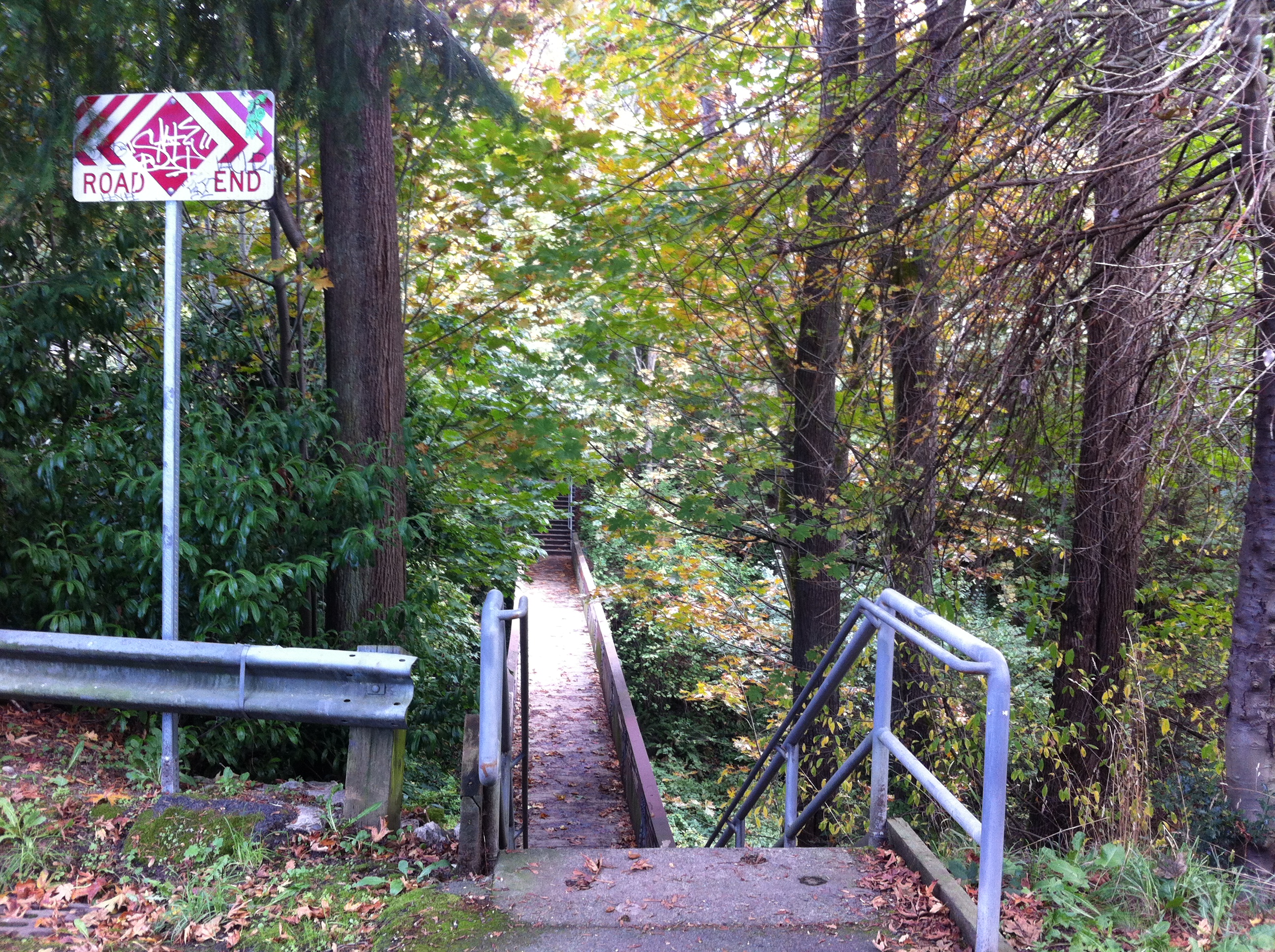 Since no street south of NE 65th and north of Ravenna Park goes all the way through, building a new bikeable and ADA accessible bridge here is the only way to make Option D a working bike route (though it is lovely if you’re on foot). Again, not impossible.
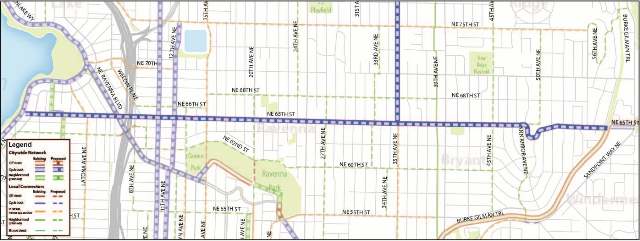
Option D’s route then continues on NE 60th Street to meet up with the 39th Ave NE greenway and its connection to the Burke-Gilman Trail and Wedgwood’s neighborhood center.
But this is five blocks (really, two long blocks) away from NE 65th Street, which is too far to be considered an adequate alternative for a bike facility on 65th itself. It is also long and winding. But the lovely connections to the park and new options for crossing I-5 do make it attractive as a project of its own. It’s just not an acceptable “alternative” to a NE 65th Street bikeway.
Option B
 I still don’t understand this option. It is less useful for creating adequate bike routes compared to options A and C, and it doesn’t address most of the concerns voiced by neighbors.
Option A
 This is the route as it appears in the current draft of the bike plan. It is simple, safe and direct. If you are going to go up the hill east of 35th to get to the Burke-Gilman or another destination there, this would provide a safe and comfortable way to get there. North of 65th, routes get even more steep.
This is the most bike-friendly option.
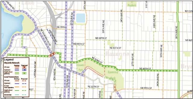
Option C
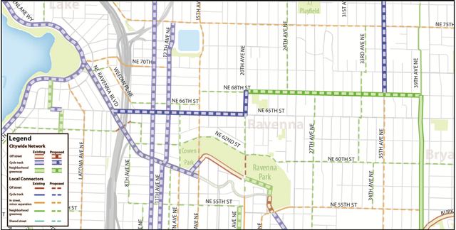 Option C is a ground-truthed and solid bike route. As we discussed in our previous post, the route shifts at 20th Ave NE with a cycle track to the west on 65th Street and a neighborhood greenway to the east on NE 68th Street (which is really one long block north of 65th).

NE 68th Street is already a very popular street for people on foot and on bikes. Sure, it is awful hilly (especially between 25th and 31st), but every street is hilly and grades are comparable to NE 65th.
The connection on 20th Ave NE is also promising, since that street is a fantastic option for a neighborhood greenway. After all, the 20th Ave bike and walk bridge through Ravenna Park might be my favorite bridge in the whole city (also, it’s a very useful transportation connection).
The cycle track west of 20th will provide a safe and direct connection under I-5 and through the main commercial segment of NE 65th Street, including the future light rail station. It would also be a chance to make the commercial area safer and easier for people on foot and, yes, people driving.
And despite some false information being spread anonymously on telephone poles in the area (seriously), such a cycle track can be constructed in a way that preserves all emergency vehicle stops and even on-street parking. These are design details that would be worked out later when the project receives funding and staff for planning and/or construction. They are not reasons to oppose placement of the project on the high-level Bike Master Plan.
This cycle track plan should be extended all the way to Green Lake as in Options A and B.
A “turn” in the route at 20th Ave NE would certainly be more confusing than simply continuing a protected bikeway on the whole street. But installing a bikeway on NE 65th Street east of 20th will be much more difficult, and some businesses in the small commercial area at Ravenna Avenue strongly oppose a project that would remove parking.
This is the compromise. It would be great to have neighborhood support behind the cycle track where it is most needed and can do the most good, even if they are a bit wary of it’s potential for success (again, the details will be hashed out later, perhaps even years later). On the other hand, while I am not convinced that losing parking would be devastating to businesses in the area, some neighborhood residents and business owners are genuinely concerned about it. So through this option (or something like it), perhaps there’s a chance to partner for safety instead of fighting for road space.
So that’s your decision when completing the online survey and engaging in discussions at the open house. Are there neighbors who are willing to rally behind compromise Option C? Or is it unwise to compromise on safety and, therefore, Option A is the only acceptable path for the plan?
UPDATE: Cascade posted their take on the options on their blog. They strongly support Option A. And they make a good point that Option C does not actually connect to Magnuson Park. There are also likely options for safety improvements of some kind on sections of 65th that would not have a cycle track in Option C.
So, here’s some thing I whipped up, which I’ll call Option C+. The dotted line is for “on street, minor separation.” Think, perhaps, a climbing lane for uphill segments. This would also better connect the PCC market with the neighborhoods around it.
And to clarify, Option A is clearly the best option. But if there seems to be room to compromise and form a neighborhood alliance behind something like Option C, let’s see where those discussions go.


Comments
45 responses to “A closer look at the proposed NE 65th St options”
My only concern regarding option C is the relatively large number of driveways along the route. Thoughts on how that could be addressed? I have a sneaking suspicion that removing access would not be well-received.
I’m willing to bet removing driveway access would not be on the table. But I believe the safety issues can be addressed during design. Even something as simple as preserving sight lines can make this issue manageable. But again, that would come later.
The Master Plan is really just about saying that there should be a protected bike lane of some kind on this street. All other nitty gritty details are delayed until later. It’s a 20-year plan.
Hi Tom.
It seems we should be running all the way to Golden Gardens with the 65th route. I realize it’s steep over Phinney Ridge, but to have an east west fully connected route connecting Magnuson, Green Lake and Golden Gardens would be great. What do you think?
-Kate
I like your suggestion to connect to the west. However, it might be better to jog over to 85th street instead of using 65th. Normally I wouldn’t recommend a jog-over as it would become a detour for those wishing to go straight through.
In this case, though 65th doesn’t really go anywhere. To the north, 85th connects with golden gardens, and to the south one can connect with market street or the BGT.
I also meant to say: you have to divert around greenlake anyway, and 85th and, say, 50th, are much less steep than the streets around 65th.
85th as a Bike Route would be dreamy. Nice! Still, though, 65th winds down that big Sunset bluff to the bike trail along Shilshole and incorporates the grade change ageeably. I’ll take 85th as a bike route, too, though. That would humanize it nicely. -Kate
I know this is only at the BMP level, but without a clear understanding of how you would get across 25th Ave NE I would be hesitant to support option C. Try to get across at 68th during the morning or evening commute. Then consider a child doing the same.
Option C would presumably have something to make crossing safer – if not a full out signal, at least something like Stone Way at 43rd. With appropriate traffic control devices, the crossing could actually be easier at 68th than at 65th – much fewer turning cars, and no need to wait for a long red light with lots of signal phases from cars turning in all directions. I do have other issues with option C, but I do consider the crossing of 25th to be a solvable problem.
The Stone/43rd solution wouldn’t work across 25th without a Stone Way-style road diet on 25th to give it a median.
A 68th/25th crossing is solvable, but is it certain it will be solved satisfactorily? I really object to the idea that we commit to a 68th St. greenway as the primary bike route in this corridor before we can commit to having a signal like the one at 58th/15th in Ballard. If that level of design isn’t appropriate today (it probably isn’t!) then the level of design inherent in erasing the 65th St. cycletrack from the BMP isn’t appropriate today either.
Tom, thank you for the analysis!
As a long time proponent of Option D I’d like to fill in some of the soft spots or issues that you’ve brought up.
There appears to be no reason why the west end of the path shouldn’t intersect directly with Ravenna Boulevard at 62nd. And why does it need to continue on 65th instead of continuing to Green Lake as the Olmsteds originally envisioned or as seen in Option C? It’s more scenic, easier for those who are not in exceptional shape and those who are the youngest cyclists to navigate (it’s level).
The legacy that the path along the north side of Ravenna Park would leave is exceptional. A pedestrian and cycle roadway would create closer to the Park boundary and provide a scenic, level path for both means of transportation. The current curb on the south side of 61st and 62nd is a wasteland. Place the new roadway (cycle track/pedestrian walkway) south of the curb in the Park.
Revised bridges across the two ravine branches are another opportunity to leave a real legacy to the city. The cost? What’s usually missing in the conversation about the direct 65th St option is the cost of engineering no fewer than eight overlays of traffic use (and that’s not the execution cost).
1. Pedestrian traffic
2. Bicycle traffic
3. Public transit traffic
4. Emergency vehicle traffic
5. Freight traffic
6. Private vehicle traffic
7. Cross traffic (all types)
8. Turning traffic (all types)
Each of these overlays needs to be examined and engineered in every option and I think that it’s a little premature to gloss over engineering around any of them at this point. It is simple enough to look for emergency, public, and freight traffic on the alternates to understand the relative costs.
Option D provides immediate access north to the light rail station along 12th Ave, south to the University down 15th, 20th and Roosevelt and to the west along Ravenna Boulevard and Green Lake. At the east end it provides essentially level access (again for the broad spectrum of riders) to the BG Trail.
I do like Option D. I just don’t see how it could be considered an alternative to removing the planned bikeway on 65th. You’ll note that option D is still maintained in Options C and A, it’s just knocked down a priority peg (in the terms of the plan, it would be considered a “neighborhood connector” rather than a “city-wide connector”).
I agree those bridges would be a great legacy for the city, and you bet I’ll be right there with you working to secure funding for them. But it’s simply not relevant to a conversation about NE 65th Street.
As you’ll note in my previous story, there is room to work with on NE 65th.
http://www.seattlebikeblog.com/2013/10/09/city-releases-bike-plan-options-for-ne-65th-street-is-a-compromise-possible/
It’s really not as busy as it seems. In fact, the road design only works to make it more dangerous than it needs to be, and nothing is gained. Sure, lots of modes need to be considered, but just because something is difficult doesn’t mean we should give up before we’ve even tried. We are capable of making a NE 65th that is safe and accessible to people of all abilities and modes of travel.
I live at 27th and 65th. I drive AND bike 65th. I am a woman in my 40’s who is not athletic. The grades between 25th and 31st on 68th are MUCH steeper than 65th. I don’t understand why 68th keeps getting pushed as an option, it really isn’t unless you are a hard core cyclist.
Why couldn’t there be a two way cycle track on 65th on the north side of the street from Ravenna all the way west? That solves the access issue to businesses and Ida Culver in the stretch from 20th to 25th.
Why are we letting primarily one, declining business on 65th drive this whole process?
There can be. I totally support Option A. I’m also searching for possible compromises. If a group of neighbors who don’t bike want to get behind a compromise like that, that could be a great partnership going forward. But if neighbors stick to the “no bikes, no way” mentality, then that’s too bad.
There’s no question that Option A is the best. But if compromise is possible, let’s talk about C and see if we can make that work.
this is not about one ‘declining business’ on ne65th dictating the drive the process. It is about serving the needs of everyone in the neighborhood, personally I would support option C and work to gain support for it in my community and see it built. I think it is a great compromise. Taking away all the parking where the street is only 36 feet wide, and giving one third of the road to a small percentage of use is what we object to, thanks , dave
Thanks for commenting, David. I think if people continue listening to each other, a solution that works for everyone can be found.
With leaders in the other Washington setting such a bad example, I know Seattle and the 65th Street neighbors can do better.
Speaking of which, just to keep ideas flowing, here’s an example of a design that could preserve some parking and make the street safer for cycling: http://www.seattlebikeblog.com/wp-content/uploads/2013/10/unnamed-st.png
Is it possible? Is there a better option? Those are things that can only be figured out through a more thorough design process than what the Bike Master Plan update can offer.
And don’t discount the number of people biking in the neighborhood. Census commute data shows Ravenna clocking in around 9%. Number of people using bikes for other trips (like to get to the store or restaurants) is unknown, but certainly higher than 9. That’s not something to disregard, and it’s only going to grow.
Thanks again.
tom thanks for your response, in the link that you post as a possible fix for ne65th how wide is that proposal, and are you using some of the sidewalk as bike lane?
David, it’s very conceptual, not based on any actual measurements (I assume you have your own measurements). But if four lanes fit now, then this is essentially four lanes of space.
You can play around with the dimensions using this website: http://streetmix.net/seabikeblog/11/ne-65th-street
My main point is that there are options, and it would be interesting to see what a city team could come up with some day when the project is funded (preferably before the opening of light rail, IMO).
Tom, I really have to disagree with you on the idea of “C” being a compromise route.
This is my neighborhood. I’ve lived here for 17 years. I’ve ridden (and driven and walked) all over it. And now my kids are riding all over it. I think I’m qualified to say none of the four are great choices.
In my opinion, the best option right now is to do something on 65th that isn’t a cycle track. A road diet such as just completed on 75th, combined with sidewalk improvements for pedestrians seems like it could be worthy of the term “compromise.”
As for an actual cycle track through the Ravenna part of 65th — regardless of whether neighborhood support exists (and probably not) — I don’t know if SDOT is ready to build (or even capable of building) the kind of infrastructure required on such a narrow, busy, confusing section of street as would be necessary to keep motorized/non-motorized relationships from getting worse and/or keeping riders from being taken away in an ambulance.
Sorry but 68th is not a good direction for a compromise. Sure, it should be a greenway and would be a great all-ages-accessible compliment to a road diet on 65th. But let’s be honest if we’re talking about it as replacement for 65th –it is not a comparable grade, nor is it an existing “popular” route.
Finally, that option C (along Ravenna park) is curious. The bit along across the bridges is (already) a great green corridor. Adding ADA/bike accessible bridges (cheaper than I thought) would make it a great pedestrian and bike connector between Roosevelt, Ravenna and Bryant, not to mention north and south along 20th from the UW to Maple Leaf.
But the way the plan “hides” most of this connector to the south of 65th all the way to the freeway, skipping all the commercial districts (Ravenna and Roosevelt) and the new LINK station) … weird, but an easy fix. Just have the route meet a connecting cycle track on 15th. That would then easily connect to a cycle track on 65th west through the Roosevelt commercial district all the way to Ravenna Blvd.
That’s my take on situation as a neighbor and rider and walker and parent. Right now the official options are a mess and I don’t feel comfortable choosing ANY of them.
I’ve only lived here 3 years, but I agree with most of what you said.
Someone once said to me at a meeting, “I just tried biking on NE 68th. How can you propose that as a greenway? It’s so steep!” She was right. However, it is a *fantastic* walking route, and so it should be a greenway. But saying it should be a “biking route” instead of 65th won’t do anything to keep people from biking on 65th.
It’s so frustrating that we’re even talking about this without any sort of plan. 65th needs a road diet, and such a thing could even be done while keeping parking on one side of 65th between 20th Ave and 25th Ave (two 11′ travel lanes, an 8′ parking lane, and a 5′ bike lane on the non-parking side). Or we could start with a road diet on the rest of 65th, and leave 20th/25th alone for now. Any of that would be a huge improvement over what we have now, and could be done next year for such a small amount of money. Sigh.
I’d support that!
Very well said, Tim K. I’ve lived at 23rd Ave. NE and 65th for nine years and agree with you wholeheartedly.
Thanks, Tim. You’re right.
Thanks Tom. Please know that really appreciate all that you do for biking in Seattle. I just don’t agree with you this time (even on the new C+) option.
I think Andres has it right in that 68th makes great sense as a Greenway. And so does 60th/61st/62nd behind the Ravenna business district.
I want them both. BUT neither is an appropriate trade or compromise against the idea of improving bicycle AND pedestrian safety and access along NE 65th through the Ravenna shopping district.
Still, I just can’t get behind “option A” without engineering drawings, a budget, and some guarantees. So far SDOT has yet to build anything close to the type of infrastructure necessary to make NE 65th — at least through Ravenna — and I fear a poor example of a cycle track would be worse (both from safety and PR perspective) than not doing anything.
Can we please kick this back to the city and have them come up with options E, F, & G or more?
My compromise idea is the pretty much what Andres mentioned — put 65th on a huge road diet. Improve sidewalks/crossings (add bulbs?) to drastically slow traffic to a human speed. That would still provide business access but eliminate some rushed cut-through traffic (In a hurry? Don’t choose 65th!). That would give bike riders who need “transportation” some breathing room on 65th, without requiring a massive cycle track structure or shunting riders to an indirect, more hilly greenway.
And then with the money we (the city) saves by not building a likely VERY expensive cycle track we can increase all-ages-access on both sides of 65th by: 1) adding new bridges in Ravenna park AND 2) designating 68th a neighborhood greenway from Roosevelt High, past the library to the Greenway at 39th.
Finally, I’m not at all concerned with the connection over the hill to Magnusen. Stopping at 39th is fine. View Ridge is both crazy long and crazy steep. It’s the exact opposite of all ages accessible, and short of adding a Trampe bicycle escalator (http://en.wikipedia.org/wiki/Trampe_bicycle_lift), nothing we do will fix that.
Sure some people will ride it. But traffic volumes are low at many of the best hill crossing points. Downhill there’s no issue keeping up with traffic (assuming you are brave enough. Many people just won’t even think about riding the hill and will cut over the the BGT via the 38th greenway, or earlier.)
The other issue is that 25th, riding down the hill to the Burke, then following that to Magnusen only takes about 5 extra minutes (for my kids!) than it does to “go over the top” — and saves a ton of sweat and tears in the process.
West from Magnusen is even slower unless you are fit enough to crank the hill hard. Survival riding/granny gearing over the hill westbound is no faster (and for some, slower) than going around.
And for the fit hill lovers — low traffic volumes and wide lanes mean they don’t need cycle track or buffered lane. Just pick a spot (I like 70th, though I still can’t figure out why SDOT didn’t put the cycle track there) and start climbing.
Am I assuming too much that option C would locate the cycle track on the north side of 65th, so that people wouldn’t have to actually cross 65th at the transition at 20th? Also, I don’t like the premise behind option C that customers = people in cars, while bikes have to be shoved out of the way. It seems entirely backwards for businesses to advocate a street design that routes people away from them, almost like people on bikes are shoplifters/loiterers who need to be kept away. The truth is that people on bikes are customers, just like anybody else, and someone who sees a store as they ride by one day might end up shopping there the next day. Also, people riding a bike to the businesses on 65th St. still need a safe path. There is plenty of parking for car customers on adjacent streets and some businesses even have off-street parking lots.
Based on where I live, I am actually a big fan of option D (I would be approaching all of the options from the 20th Ave. bridge over Ravenna Park). But I also understand that option D is a bit far from 65th St. to be a substitute for something on 65th. How about both options A and D together?
Agreed. Businesses like the Bagel Oasis, Zekes, 3rd Place Books and it’s associated restaurants should be naturally allies to bringing bikes to their front doors. I would guess it would increase their businesses substantially to make this less area more inviting to actual people, even if it makes it slightly more difficult for the through car traffic.
Have any of them weighed in?
I was discussing the options with my kids last night at dinner. We are planning on walking over to the meeting tonight so my kids can provide their input. My son asked why people wouldn’t want a cycle track. I gave him some of the reasons. He just responded, “If I owned a business there I would put in a bike rack and rent the spaces”. Maybe not a solid business plan but at least he is looking at the big picture.
OMG, that’s adorable!
And maybe he’s actually a little ahead of his time. Imagine a day when there are so many bikes that premium bike parking gains market value…
He’s got my vote in the 2033 mayoral election!
Seems that even though the attitude towards bicycles and cycling in this town has progressed in leaps and bounds over the past years, we are still talking about where to put the cyclists.
If we are trying to improve conditions for all users, then at the very least bicycles need to stay on NE65th through the Ravenna commercial strip. Pedestrians, transit and bicycles need to be given equal thought and consideration as cars currently receive. Thumbs up for the idea of 65th going on a “diet” to make conditions safer for all. Green ways are wonderful as well, but should be considered in addition to bicycle, transit and pedestrian infrastructure within neighborhood “cores” otherwise the signal sent is simply a continuation of the current paradigm where pedestrians and bicycles are moved/marginalized out of a concern for safety and cars get preferential treatment, a difference in degree not in kind.
I am looking forward to the day where the discussion is about where to redirect the cars to make room for people within local commercial districts.
You’re right.
OK, so here’s what I’m hearing:
In response to the question of whether Option C is an acceptable compromise, opinion in the comments so far seems to strongly say, “No.”
Thank you all for your thoughts. I am inclined to agree with what you are saying. I will be choosing Option A in the survey myself.
I’ll pipe in to support a direct-on-65th route. I didn’t comment earlier because I’m not that familiar with all the concerns through that area. However, I bicycled from Greenlake to Sandpoint on Saturday and went straight through on 65th. There was a lot of traffic congestion in certain areas and a bikeway of some sort would have been nice (but not one with car doors in it).
I could have chosen a different street but, just like anyone else, I want to get to my destination without detours. 65th is my choice.
Ok, so a little fun here…
From Shilshole to Sandpoint one encounters, I think, the most number of ridge crossings anywhere in the city. To truly make this route accessible for tots to teeterers, we need to level the route.
How about building tunnels through each ridge. Instead of Bertha, the worlds largest diameter tunnel boring machine, we could employ Bambino, the worlds smallest diameter tunnel boring machine :)
And Greenlake could have a bicycle powered paddle raft.
I grew up riding in this neighborhood, and dislike riding on 65th. I can understand why the knee-jerk reaction to how unfriendly 65th is may be to want some sort of protected facility on 65th. However, take a moment and look around (StreetView is nice for this) at all the driveways and intersections (street and alley) along the 65th corridor. What would a protected bike lane look like here? Unless you are proposing removing alley access and removing driveways, you’re going to have frequent interruptions to any protected lane. All of the safety issues with cycletracks and uncontrolled intersections are tremendously magnified on a street like this, and you can’t simply handwave away that it’ll be figured out when it gets to the design stage.
A cycletrack here would be subject to so many compromises (both from the budget and scope sides) that it would in all likelihood end up being more dangerous at every intersection than the current street configuration. The routing along Option D is a much superior alignment for a greenway, and a road diet for 65th would do a better job of making a safe facility for the cyclists that are willing to ride it.
I want to take this comment up the abstraction scale, because this is the bike master plan we’re talking about, not specific design proposals. So… here goes. I think 65th between 20th and 25th is a key example of the confusion of American cities. 65th is a street provides direct local access to two significant business districts plus a number of other destinations. But we also seem to insist that it must be kept clear for through traffic across its entire length.
Along much of the length of 65th the road is wide enough to allow this. Now we want to add excellent bike facilities, and still most of the road is wide enough to let us avoid confronting our confusion, even in the busy Roosevelt business district. The narrow width of 65th between 20th and 25th forces our hand.
Today, that is the only part of 65th where there’s serious tension between its through-traffic function and its local-access function. Through traffic demanding fast speeds makes it harder to cross the street, to park a car, to turn on and off the street, or to arrive on bike in any way. On the other hand, high turning volumes, dense parking, and frequent traffic signals slow down through traffic. In Roosevelt the road width provides a buffer for some of these things, but not here.
Cycling advocates want a better bike route. Business leaders want to preserve parking. We assume that we can’t have both, and the existing tension seems to indicate the road is full. But why do we assume that the road must carry fast through-traffic? I bet if the road was redesigned around its local access function, sacrificing volume and speed of through traffic, we could provide safe passage for cyclists and easier crossing conditions while preserving the short-term parking.
I don’t know exactly what such a design would look like, and I don’t know how that concept would incorporate existing transit service on the street. Maybe 65th is too far from other east-west arterials to lose much capacity without unacceptable diversion. I only know that important public streets aren’t always major routes for cars going through, even in the US, from skyscraper cities to small towns and everywhere in between. Look at The Ave; Ballard Avenue; Broadway in Midtown Manhattan; Paxton, IL’s Market Street.
Well said, Al! I propose we print this out, hand it to the SDOT reps at the meeting tonight, and then all head over to 3rd Place for a pint ;-)
This is precisely the the point I was trying to make above (“if you are in a hurry, don’t choose 65th”) — but didn’t do it near as well.
I don’t think we need to go much farther than Wallingford to see how this could work. Anyone hurrying between I-5 to& Phinney Ridge in a car naturally skips 45th and uses 50th for their east-west travel.
Meanwhile, 45th works well for business district access. Cars can park. People can shop. Easy-peasy. It’s also a heck of a lot more pleasant to ride or walk on than 65th.
Throw in some greenways on 68th and 60th/61st/62nd and I’ll be happy to call that a successful compromise!
Here here Al! Well articulated. I agree. Thank you all for your great input here.
In the survey, it mentions nothing about 63rd St in Option D, but you mention it in your blog…which is correct?
It’s on the map (hard to read street names, but the green section west of I-5 is 63rd).
Option D, or one that uses NE 68th St both seem to be reasonable options, and wouldn’t destroy yet another E-W route a-la NE 75th St… I don’t see how you can claim that the overall grade between 68th and 65th are significantly different.
I’d like to see more focus on bike routes in Mr. McGinn’s neighborhood – watch what happens if you proposed a similar plan for California Ave, Admiral Way, or dare I say it 35th Ave SW. I think for the amount of agenda pushing they do to NE Seattle for bikes – we seem to take it pretty well.
McGinn lives in Greenwood, not West Seattle. On the BMP map Greenwood Avenue (a street with major business districts and lots of transit service) is a proposed cycletrack route.
In West Seattle, since you mention it, there are proposed cycletracks on Admiral and 35th Ave SW. Also, Delridge.
None of this indicates any specific, imminent plan, merely that there’s a need for bike routes of that quality in this corridor. Any actual plan would need to be studied and designed specifically, and that process might result in something like Option C even if the map looks like Option A. NE Seattle is the only neighborhood that’s protested that kind of designation so fiercely.
Yeah, it’s a real shame that people can’t drive cars on NE 75th any more.
Er, wait, did you mean something else? You must’ve meant something else.
yet another option: NE 71st Street/NE 70th Street between Greenlake and 20th Avenue NE; NE 20th Avenue NE between NE 70th and 75th streets; NE 75th Street between 20th and 50th avenues NE; 50th Avenue NE to both NE 70th and 65th streets to connect with BGT, Sand Point Way NE, and Magnusson Park. Both Brooklyn and 20th avenues NE could be north-south bike emphasis streets.
[…] Of the thousands of comments received on the plan, NE 65th Street received by far the most attention. The plan includes a NE 65th Street option that is an attempt at compromise, though it will likely disappoint some people who bike in the area and some neighbors who opposed any protected bike lanes at all on the street. During community outreach, the option they went with was known as Option C. […]
[…] wrote pretty extensively about this street back in 2013 when there was a significant backlash against the Bike Master […]