
The last day to comment on the second draft of the Bicycle Master Plan is Friday. Email your comments to [email protected].
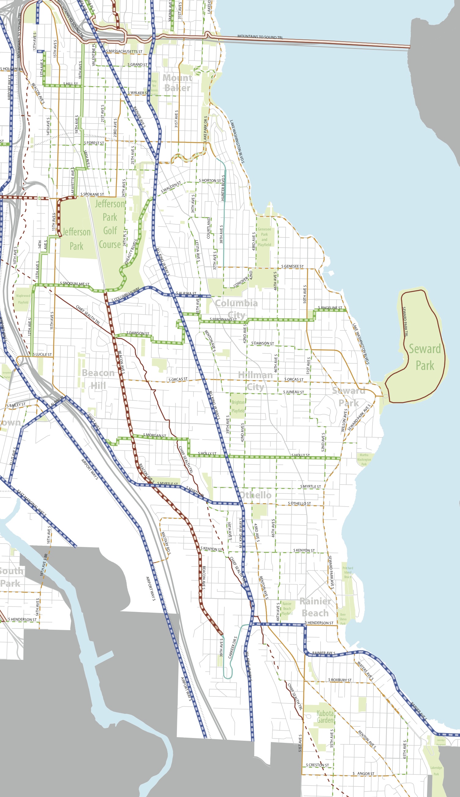
Southeast Seattle
 During review of the first draft of the Bike Master Plan, we said this:
While changes to Rainier would certainly be the most controversial project in southeast Seattle, it also has the greatest potential to revolutionize not only the bikeability of southeast Seattle, but also dramatically increase walking safety.
— Advertisement —
Unfortunately, this remains true in the second draft of the plan. In fact, very little has changed in the plan for SE Seattle/Rainier Valley. Since this is meant to be a 20-year plan, does this mean the city aspires to keep Rainier Ave as one of the city’s most dangerous streets until at least the year 2033? The residents of Rainier Valley deserve better than that.
Aside from Rainier Ave, the plan for Southeast Seattle still includes much-needed neighborhood greenways and ambitious plans for protected bike lanes on MLK (apparently the excuse for not including protected lanes on Rainier). It also includes bike lanes on Lake Washington Boulevard and Seward Park Ave. The plan also suggests completing the gaps in the Chief Sealth Trail (especially the very confusing gap south of S Myrtle Pl by New Holly).
Beacon Hill
There is a little work to do on the Beacon Hill plan. For one, there is no all-ages-and-abilities connection from the Jose Rizal Bridge to the heart of the neighborhood and the solid Beacon Hill Neighborhood Greenways network as proposed by the excellent community organization Beacon BIKES. There is a bad gap on 12th Ave S north of Massachusetts and another on 14th Ave S north of Beacon Ave (Hill St is, well, too hilly for a bike route. So hilly that at least one block of it is a staircase). Or 15th could be upgraded to a truly safe bikeway, which would be faster and flatter, but would not serve the neighborhood to its west very well due to geographic issues.
The plan also calls for a trail on Spokane St between 14th Ave S and Sodo that I can only assume is either a mistake or a completely awesome and super hilly trail through the greenbelt and under I-5.
But the biggest missing piece in the Beacon Hill plan is a safe bike facility on Beacon Ave through Jefferson Park. This was on the original draft and is absolutely vital and achievable (there is plenty of space). There is simply no reasonable alternative to having a safe bike facility on Beacon Ave through this section, which is the most direct connection between the north and south ends of the neighborhood. Since the bike commute rate drops dramatically south of Jefferson Park, a safe Beacon Ave could help bridge the bikeability gap and should be added back to the plan.
Sodo
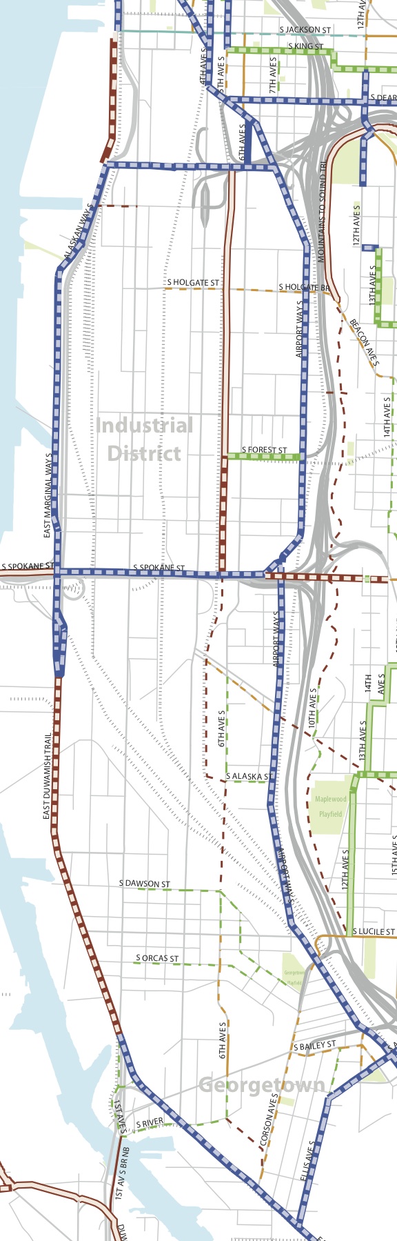 Sodo’s most glaring change compared to the first draft of the plan is deletion of 1st Ave S. This is a huge mistake and missed opportunity. 1st Ave S is incredibly wide, and it would really not be difficult or intrusive to freight to build a safe bike facility there. It connects to a ton of jobs and destinations even without the planned arena south of Safeco Field.
Industry spokespeople also understand that 1st Ave S is a dangerous street.
Even when there is no train, there are very few connections (and even fewer safe connections) between E Marginal Way and 1st Ave S. So if the impetus for removing 1st ave S from the plan was due to plans for a safe bike facility on E Marginal, that decision should be revisited. They might look close together on a map, but they are in no way interchangeable as bike routes.
If you observe 1st Ave today, you see there are already a lot of people biking there even without anything resembling a safe bike facility. There is a clear need for a safe facility here today, let alone in the next 20 years. Since such a project would not affect freight mobility, it should be added back into the plan.
Stay tuned this week for posts about the rest of the city. If you believe I missed anything here, be sure to say so in the comments below.


Comments
10 responses to “Bike Master Plan Draft 2: Sodo, Beacon Hill and Southeast Seattle”
Although I live two blocks west of MLK, if I could only pick one, I think I would rather have a good bike facility on Rainier.
MLK has a *lot* of stop lights because of the light rail (when I drive, I sometimes avoid it, honestly), which slows traffic sometimes — giving bikers at least a little bit of time to get ahead of traffic as they take a short stint on MLK. (I frequently bike a couple of blocks on MLK to connect from a side street to the light rail. Not ideal and I’ve had some scary experiences, but it’s tolerable.) Of course it would be ideal to be able to bike on MLK the whole way, safely.
Rainier is just terrifying all the way through currently. It’s such a wonderfully flat street that connects with so many more neighborhood and transit centers. It’s a shame it’s not friendly to bikes.
I also suspect that the residents who put up with the construction for light rail on MLK will protest any more traffic interruptions to install bike infrastructure on MLK. Of course that doesn’t mean it shouldn’t be done, but I can see that being a difficult sell :(.
Also, huzzah to suggesting bike facilities on Beacon through Jefferson Park — that is a *wonderful* road for biking as long as drivers don’t get cranky!
… off to send an email now.
Rainer Ave, south of Seward Park is already pretty nice for bicycling.
Regarding SODO, it looks like the plan includes an off-street route on 6th S. That could work, however it does not connect well to downtown. 2nd ave dumps you on 4th S and a convenient connection would need to exist to 6th S.
Another omission in my area (Queen Anne) is a connection from the hill to Westlake (where a cycle track is proposed). They show Galer street. But that is totally impractical under current conditions – there’s the ped bridge over aurora and 100+ steps and not to mention it’s very steep.
I’ll make these comments to bmpudate.
I’d certainly say going north-south through north Beacon Hill is an enormous gap for a 20-year plan.
Cycling conditions on 1st Ave S wouldn’t be nearly so important if it was easier to get from Marginal Way over to 1st, but it isn’t.
Making Rainier safer for bikes and peds would be great. It is flat and fast but so dangerous right now. All the surrounding neighborhoods have a lot of hills and unless you are in great shape or can afford an e-bike it can be a challenge to easily go north-south.
I wouldn’t be so quick to dismiss MLK as at least as good a N/S alternative as Rainier, at least between Mt. Baker and Othello stations. I’m not sure what the average daily traffic counts are for MLK, but I’m guessing they’re at least a little bit under 25,000 on average weekday. Because of this over-capacity, traffic is often moving at high speeds. MLK is relatively flat, flatter than Rainier.
MLK also connects to several important destinations -three light rail station, 900 and 1400 housing units respectively at Rainier Vista and New Holly (and still more to come), the Filipino Community Center, and grocery stores and retail clusters at Othello and Graham. And there are flat short connections between MLK and Columbia City at Edmonds and Hillman City at Dawson, which could both get greenway treatments. Edmonds is also a direct connection between MLK and the Columbia City Farmer’s Market and new PCC grocery store.
None of this is to say that Rainier doesn’t need to be calmed, especially at Genesee through to Columbia City and Hillman City and a bike facility might be a good tool to help with that calming, but not at the expense of eliminating the cycle track from MLK.
I agree that MLK is a good option. I originally thought they chose MLK because there was existing infrastructure to support a cycletrack, but after looking at satellite view I don’t see how there will be enough room to keep both car lanes.
Yeah, it’s gonna be expensive. The city and sound transit really screwed up by not including a bike facility when installing light rail.
[…] Bike Blog is all over the Bicycle Master Plan; last day for comment is […]
that Spokane proposal is actually really sweet, and could be a great way to get mid-hill. Currently there is a stairway you can climb under the freeway and then it has either a death-defying dodge around off-freeway traffic or another down and up flight of stairs and then you’re on the south sidewalk of Spokane St and ready to grind up and homeward. Beats riding all the way up town or down to Georgetown if it’s late.
Well, this was a nice shortcut until last winter when DOT chained the stairway off and parked all their crap there.